Rio Grande

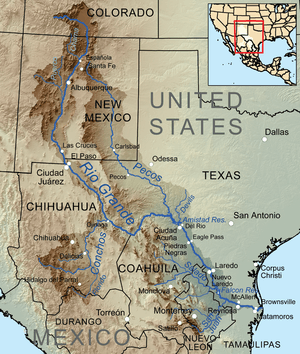
The Rio Grande (/ˈriːoʊ ˈɡrænd/ or /ˈriːoʊ ˈɡrɑːndɛ/; Spanish: Río Bravo del Norte, pronounced: [ˈri.o ˈβɾaβo ðel ˈnorte] or simply Río Bravo) is one of the principal rivers in the southwest United States and northern Mexico (the other being the Colorado River). The Rio Grande rises from south-central Colorado in the United States and flows to the Gulf of Mexico.[5] Along the way, it forms part of the Mexico–United States border. According to the International Boundary and Water Commission, its total length was 1,896 miles (3,051 km) in the late 1980s, though course shifts occasionally result in length changes. Depending on how it is measured, the Rio Grande is the fourth- or fifth-longest river system in North America.[1]
The river serves as part of the natural border between the U.S. state of Texas and the Mexican states of Chihuahua, Coahuila, Nuevo León, and Tamaulipas. A very short stretch of the river serves as part of the boundary between the U.S. states of Texas and New Mexico. Since the mid–20th century, heavy water consumption of farms and cities along with many large diversion dams on the river has left only 20% of its natural discharge to flow to the Gulf. Near the river's mouth, the heavily irrigated lower Rio Grande Valley is an important agricultural region. The Rio Grande is one of 19 Great Waters recognized by America's Great Waters Coalition.[6]
The Rio Grande's watershed covers 182,200 square miles (472,000 km2).[3] Many endorheic basins are situated within, or adjacent to, the Rio Grande's basin, and these are sometimes included in the river basin's total area, increasing its size to about 336,000 square miles (870,000 km2).[7]
Geography

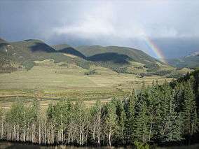
The Rio Grande rises in the western part of the Rio Grande National Forest in the U.S. state of Colorado. The river is formed by the joining of several streams at the base of Canby Mountain in the San Juan Mountains, just east of the Continental Divide. From there, it flows through the San Luis Valley, then south into New Mexico, passing through Española, Albuquerque, and Las Cruces to El Paso, Texas and Ciudad Juárez, Chihuahua. Below El Paso, it serves as part of the border between the United States and Mexico.
The official river border measurement ranges from 889 miles (1,431 km) to 1,248 miles (2,008 km), depending on how the river is measured.[1] A major tributary, the Rio Conchos, enters at Ojinaga, Chihuahua, below El Paso, and supplies most of the water in the border segment. Other well-known tributaries include the Pecos and the smaller Devils, which join the Rio Grande on the site of Amistad Dam. Despite its name and length, the Rio Grande is not navigable by ocean-going ships, nor do smaller passenger boats or cargo barges use it as a route. It is barely navigable at all, except by small boats in a few places; at its deepest point, the river's depth is only 60 feet (18 m),[8] and its average depth is far less: about ten feet.
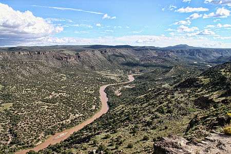
The Rio Grande rises in high mountains and flows for much of its length at high elevation; El Paso is 3,762 feet (1,147 m) above sea level. In New Mexico, the river flows through the Rio Grande rift from one sediment-filled basin to another, cutting canyons between the basins and supporting a fragile bosque ecosystem on its flood plain. From El Paso eastward, the river flows through desert. Only in the subtropical lower Rio Grande Valley does extensive irrigated agriculture exist. The river ends in a small, sandy delta at the Gulf of Mexico. During portions of 2001 and 2002, the mouth of the Rio Grande was blocked by a sandbar. In the fall of 2003, the sandbar was cleared by high river flows around 7,063 cubic feet per second (200 m3/s).[4]
Navigation
Navigation was active during much of the 19th century,[9] with over 200 different steamboats operating between the river's mouth close to Brownsville, and Rio Grande City, Texas. Many steamboats from the Ohio and Mississippi Rivers were requisitioned by the US government and moved to the Rio Grande during the Mexican War in 1846. They provided transport for the U.S. Army, under General Zachary Taylor, to invade Monterrey, Mexico, via Camargo Municipality, Tamaulipas. Army engineers recommended that with small improvements, the river could easily be made navigable as far north as El Paso. Those recommendations were never acted upon.
The Brownsville & Matamoros International Bridge, a large swing bridge, dates back to 1910 and is still in use today by automobiles and railroad trains, connecting Brownsville with Matamoros, Tamaulipas. It has not been opened since the early 1900s, though, when the last of the big steamboats disappeared. The bridge is now operated by the Brownsville and Matamoros Bridge Company, a joint venture between the Mexican government and the Union Pacific Railroad.
At the mouth of the Rio Grande, on the Mexican side, was the large commercial port of Bagdad. During the American Civil War, this was the only legitimate port of the Confederacy. European warships anchored offshore to maintain the port's neutrality, and managed to do so successfully throughout that conflict, despite occasional stare-downs with blockading ships from the US Navy. It was a shallow-draft river port, with several smaller vessels that hauled cargo to and from the deeper-draft cargo ships anchored off shore. These deeper-draft ships could not cross the shallow sandbar at the mouth of the river. The port's commerce was European military supplies, in exchange for bales of cotton.
History

During the late-1830s and early-1840s, the river marked the disputed border between Mexico and the nascent Republic of Texas; Mexico marked the border at the Nueces River. The disagreement provided part of the rationale for the US invasion of Mexico in 1846, after Texas had been admitted as a new state. Since 1848, the Rio Grande has marked the boundary between Mexico and the United States from the twin cities of El Paso, Texas, and Ciudad Juárez, Chihuahua, to the Gulf of Mexico. As such, crossing the river was the escape route used by some Texan slaves to seek freedom. Mexico had liberal colonization policies and had abolished slavery in 1828.[10]
In 1944, the US and Mexico signed a treaty regarding the river,[11] and in 1997, the US designated the Rio Grande as one of the American Heritage Rivers. Two portions of the Rio Grande are designated National Wild and Scenic Rivers System, one in northern New Mexico and the other in Texas, at Big Bend National Park.
In the summer of 2001, a 328-foot (100 m)-wide sandbar formed at the mouth of the river, marking the first time in recorded history that the Rio Grande failed to empty into the Gulf of Mexico. The sandbar was subsequently dredged, but it reformed almost immediately. Spring rains the following year flushed the reformed sandbar out to sea, but it returned in the summer of 2002. As of the fall of 2003, the river once again reaches the Gulf.[4]
River modifications
The United States and Mexico share the water of the river under a series of agreements administered by the International Boundary and Water Commission (IWBC), US-Mexico. The most notable of these treaties were signed in 1906 and 1944.[12][13] The IBWC traces its institutional roots to 1889, when the International Boundary Committee was established to maintain the border. The IBWC today also allocates river waters between the two nations, and provides for flood control and water sanitation.
Use of that water belonging to the United States is regulated by the Rio Grande Compact, an interstate pact between Colorado, New Mexico, and Texas. The water of the Rio Grande is over-appropriated: that is, more users for the water exist than water in the river. Because of both drought and overuse, the section from El Paso downstream through Ojinaga was recently tagged "The Forgotten River" by those wishing to bring attention to the river's deteriorated condition.[14]

A number of dams are on the Rio Grande, including Rio Grande Dam, Cochiti Dam, Elephant Butte Dam, Caballo Dam, Amistad Dam, Falcon Dam, Anzalduas Dam, and Retamal Dam. In southern New Mexico and the upper portion of the Texas border segment, the river's discharge dwindles. Diversions, mainly for agricultural irrigation, have increased the natural decrease in flow such that by the time the river reaches Presidio, little or no water is left. Below Presidio, the Rio Conchos restores the flow of water.[1] Near Presidio, the river's discharge is frequently zero. Its average discharge is 178 cubic feet per second (5 m3/s), down from 945 cubic feet per second (27 m3/s) at Elephant Butte Dam. Supplemented by other tributaries, the Rio Grande's discharge increases to its maximum annual average of 3,504 cubic feet per second (99 m3/s) near Rio Grande City. Large diversions for irrigation below Rio Grande City reduce the river's average flow to 889 cubic feet per second (25 m3/s) at Brownsville and Matamoros.[4]
Crossings
The major international border crossings along the river are at Ciudad Juárez and El Paso; Presidio, and Ojinaga; Laredo, and Nuevo Laredo; McAllen and Reynosa; and Brownsville and Matamoros. Other notable border towns are the Texas/Coahuila pairings of Del Rio–Ciudad Acuña and Eagle Pass–Piedras Negras.
Names and pronunciation

Río Grande is Spanish for "Big River" and Río Grande del Norte means "Great River of the North". In English, Rio Grande is pronounced either /ˈriːoʊ ˈɡrænd/ or /ˈriːoʊ ˈɡrɑːndeɪ/. Because río means "river" in Spanish, the phrase Rio Grande River is redundant.
In Mexico, it is known as Río Bravo or Río Bravo del Norte, bravo meaning (among other things) "furious" or "agitated".
Historically, the Pueblo and Navajo peoples also had names for the Rio Grande/Rio Bravo:
- mets'ichi chena, Keresan, "Big River"
- posoge, Tewa, "Big River"
- paslápaane, Tiwa, "Big River"
- hañapakwa, Towa, "Great Waters"
The four Pueblo names likely antedated the Spanish entrada by several centuries.[15]
Rio del Norte was most commonly used for the upper Rio Grande (roughly, within the present-day borders of New Mexico) from Spanish colonial times to the end of the Mexican period in the mid-19th century. This use was first documented by the Spanish in 1582. Early American settlers in South Texas began to use the modern 'English' name Rio Grande. By the late 19th century, in the United States, the name Rio Grande had become standard in being applied to the entire river, from Colorado to the sea.[15]
By 1602, Río Bravo had become the standard Spanish name for the lower river, below its confluence with the Rio Conchos.[15]
Tributaries
The largest tributary of the Rio Grande by discharge is the Rio Conchos, which contributes almost twice as much water as any other. In terms of drainage basin size, the Pecos River is the largest.
| Tributary | Average discharge | Drainage basin | ||
|---|---|---|---|---|
| cu ft/s | m3/s | sq mi | km2 | |
| San Juan River | 368 | 10[4] | 12,950 | 33,500[4] |
| Rio Alamo | 130 | 3.68[4] | 1,675 | 4,340[4] |
| Rio Salado | 354 | 10.0[4] | 23,323 | 60,400 [4] |
| Rio San Rodrigo | 130 | 3.68[4] | 1,050 | 2,720[4] |
| Devils River | 362 | 10.3[4] | 137 | 355[17] |
| Pecos River | 265 | 7.50[4] | 44,402 | 115,000[18] |
| Rio Conchos | 848 | 24.0[4] | 26,400 | 68,400[19] |
| Rio Puerco | 39.5 | 1.1[20] | 7,350 | 19,000[20] |
| Jemez River | 59.5 | 1.68[21] | 1,038 | 2,688[21] |
| Santa Fe River | 10.9 | 0.31[22] | 231 | 598.3[22] |
| Rio Chama | 571 | 16.2[23] | 3,144 | 8,143[23] |
| Conejos River | 176 | 4.98[24] | 887 | 2,297[24] |
See also
- Chihuahuan Desert
- List of international border rivers
- List of longest rivers of Mexico
- List of longest rivers of the United States (by main stem)
- List of rivers of Colorado
- List of rivers of New Mexico
- List of rivers of Texas
- Rio Bravo, Texas
- Rio Grande border disputes
- Rio Grande dams and diversions
- Rio Grande Gorge
- Rio Grande Trail
- Rio Grande Wild and Scenic River
- Trans-Pecos
- West Texas
Notes
- 1 2 3 4 5 6 Metz, Leon C. "Rio Grande". The Handbook of Texas Online. Retrieved 17 July 2010.
- 1 2 U.S. Geological Survey Geographic Names Information System: Rio Grande
- 1 2 "Rio Grande NASQAN Program". United States Geological Survey. Retrieved 17 July 2010.
- 1 2 3 4 5 6 7 8 9 10 11 12 13 14 15 "Water Bulletin Number 75: Flow of the Rio Grande and Related Data; From Elephant Butte Dam, New Mexico to the Gulf of Mexico". International Boundary and Water Commission. 2005. Retrieved 17 July 2010.
- ↑ Mighty Rio Grande Now a Trickle Under Siege April 12, 2015
- ↑ National Wildlife Federation (August 18, 2010). "America's Great Waters Coalition". Retrieved 2011-08-26.
- ↑ Benke, Arthur C.; Colbert E. Cushing (2005). Rivers of North America. Academic Press. pp. 186–192. ISBN 978-0-12-088253-3.
- ↑ "Rio Grande River". Encyclopedia Britannica. Retrieved May 18, 2016.
In some places the depth of the river has varied from nearly 60 feet (18 metres) to a bare trickle or nothing.
- ↑ Tom Lea (1957) The King Ranch writes that Richard King made his fortune as a riverman on the Rio Grande before he proposed marriage to Henrietta and started his cattle ranch.
- ↑ "The UGRR on the Rio Grande"
- ↑ "Bibliography on Water Resources and International Law: Rio Grande". Peace Palace Library. Retrieved 2010-12-23.
- ↑ IBWC: Treaties Between the U.S. and Mexico
- ↑ Thompson, Olivia N., "Binational Water Management: Perspectives of Local Texas Officials in the U.S.-Mexico Border Region" (2009). Applied Research Projects. Texas State University. Paper 313.
- ↑ "Rio Grande Sucked Dry for Irrigation, Industry", CNN Saturday Morning News, (Aired June 9, 2001)]
- 1 2 3 Source for historical names: Carroll L. Riley, 1995, Rio del Norte, University of Utah Press. ISBN 0-87480-496-5
- ↑ For the spelling of Navajo terms: Young, Robert W & William Morgan, Sr. The Navajo Language. A Grammar and Colloquial Dictionary. University of New Mexico Press. Albuquerque, NM: 1987.
- ↑ "Devils River Protection Campaign, Devils River Conservation Easements". The Nature Conservancy. Retrieved 22 July 2010.
- ↑ Largest Rivers of the United States, USGS
- ↑ "The Rio Conchos: An Essential Ribbon of Life". Environmental Defense Fund. Retrieved 20 July 2010.
- 1 2 "Water resources data for the United States, Water Year 2009; gage 08353000 Rio Puerco near Barnardo, NM" (PDF). USGS. Retrieved 21 July 2010.
- 1 2 "Water resources data for the United States, Water Year 2009; gage 08329000, Jemez River below Jemez Canyon Dam, NM" (PDF). USGS. Retrieved 20 July 2010.
- 1 2 "Water resources data for the United States, Water Year 2009; gage 08317200 Santa Fe River above Cochiti Lake, NM" (PDF). USGS. Retrieved 21 July 2010.
- 1 2 "Water resources data for the United States, Water Year 2009; gage 08290000, Rio Chama near Chamita, NM" (PDF). USGS. Retrieved 21 July 2010.
- 1 2 "Water resources data for the United States, Water Year 2009; gage 08249000, Conejos River near Lasauses, CO" (PDF). USGS. Retrieved 21 July 2010.
Further reading
- D¡az, George T. Border Contraband: A History of Smuggling across the Rio Grande (University of Texas Press, 2015) xiv, 241 pp.
- Horgan, Paul (1991). Great River: The Rio Grande in North American History (4th ed.). Hanover, NH: Wesleyan University Press. ISBN 0-8195-6251-3.; Pulitzer Prize
- Kearney, Milo; Anthony K. Knopp (1995). Boom and Bust: The Historical Cycles of Matamoros and Brownsville. Austin, Tex: Eakin Press. ISBN 978-0-89015-815-9.
- Kelley, Pat (1986). River of Lost Dreams: Navigation on the Rio Grande. Lincoln: University of Nebraska Press. ISBN 978-0-8032-2712-5.
- Lea, Tom (1957). The King Ranch. Boston: Little, Brown. ISBN 978-0-316-51745-4.
Primary sources
- Coker, Caleb (1992). The News from Brownsville: Helen Chapman's Letters from the Texas Military Frontier, 1848-1852. Austin, Tex: Texas State Historical Association. ISBN 0-87611-115-0.
External links
| Wikimedia Commons has media related to Rio Grande (river). |
- Border Stories: the only hand pulled ferry on the Rio Grande (video)
- 1854 map of Rio Grande entrance (hosted by the Portal to Texas History).
- Rio Grande Cam – in Mission Texas. Mexico is on the left and the US is on the right.
| Rivers | ||
|---|---|---|