Blokland, South Holland
| Blokland | |
|---|---|
| Hamlet | |
 | |
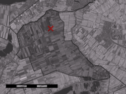 Blokland in the municipality of Liemeer. | |
| Coordinates: 52°11′32″N 4°46′24″E / 52.19222°N 4.77333°ECoordinates: 52°11′32″N 4°46′24″E / 52.19222°N 4.77333°E | |
| Country | Netherlands |
| Province | Zuid-Holland |
| Municipality | Nieuwkoop |
| Time zone | CET (UTC+1) |
| • Summer (DST) | CEST (UTC+2) |
Blokland is a hamlet in the Dutch province of South Holland. It is a part of the municipality of Liemeer, and lies about 12 km northeast of Alphen aan den Rijn.[1]
The area Blokland, in which the hamlet is located, used to be part of Uithoorn, but became part of Mijdrecht in 1811.[2] The eastern half of the area, Polder Blokland, still is part of the municipality of De Ronde Venen in the province of Utrecht (which includes Mijdrecht); the western half of the area, part of Polder Zevenhoven, is part of Liemeer in the province South Holland. Confusingly, the hamlet itself lies in Polder Zevenhoven; the houses in Polder Blokland are part of the hamlets Kromme Mijdrecht and De Hoef.
References
- ↑ ANWB Topografische Atlas Nederland, Topografische Dienst and ANWB, 2005.
- ↑ Abraham Jacob van der Aa, "Aardrijkskundig woordenboek der Nederlanden", vol. 2 (B), 1840.
This article is issued from Wikipedia - version of the 3/15/2013. The text is available under the Creative Commons Attribution/Share Alike but additional terms may apply for the media files.