Blyth railway station
| Blyth | |
|---|---|
|
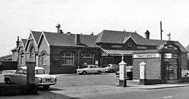
View from street in 1965 | |
| Location | |
| Place | Blyth |
| Area | Northumberland |
| Operations | |
| Pre-grouping | North Eastern Railway |
| Post-grouping |
London and North Eastern Railway British Railways |
| Platforms | 2 |
| History | |
| 3 March 1847 | First station opened |
| 1 May 1867 |
Second station opened; first station closed |
| 1894–96 | Rebuilt |
| 2 November 1964 | Closed |
| 1972 | Demolished |
| Disused railway stations in the United Kingdom | |
|
Closed railway stations in Britain A B C D–F G H–J K–L M–O P–R S T–V W–Z | |
|
| |
Blyth railway station served Blyth, Northumberland on the Blyth Branch line[1] in Northeast England.
History
The Blyth, Seghill and Percy Main Railway opened the line to Blyth on 3 March 1847[2] and the first station was at Croft Street (now King Street).[3] On 1 May 1867 a new station was opened to replace the original station.[4] It was at the north end of Turner Street[1] (now part of Regent Street) on the site now occupied by Morrisons supermarket and the Community Hospital.
The Blyth, Seghill and Percy Main Railway became the Blyth and Tyne Railway in 1853 and was taken over by the North Eastern Railway (NER) in 1874. By the 1890s the increase in goods and passenger traffic[5] was such that a new station was needed. The NER originally planned to build a new station on newly reclaimed land on Bridge Street, between Union Street and Beaconsfield Street, but these were turned down after an objection from the neighbouring Thomas Knight Memorial Hospital, on the grounds of noise.[6]
The NER therefore rebuilt the existing station between 1894 and 1896,[7] at a cost of £20,000. Most of the building was by J & W Simpson of Blyth.[5] Despite being next to a through line, the station was a terminus. It faced Turner Street and had a single island platform projecting from the rear which was half covered by a glazed apex canopy.[5] Adjacent were a goods shed next to Delaval Terrace and a coaling stage. To the west stood South Blyth loco shed, first built in 1879 with three roads and extended to six roads in 1895,[8] and a cattle dock. To the north passed the freight-only lines to the NER coaling staiths, Blyth gas works, Blyth Harbour Commission and shipyard.[9]
The station originally had two signal boxes: Blyth Signal Box at the end of the passenger platforms and Blyth Crossing Box controlling the level crossing near the engine shed on Renwick Road (previously Alexandra Crescent). Blyth Signal Box was destroyed by a German parachute mine on the night of 25 April 1941, killing the signaller instantly.[10] Thereafter only Blyth Crossing Box was used.
Passenger services were withdrawn on 2 November 1964[4] under The Reshaping of British Railways; the station buildings stood derelict until they were demolished in 1972.[7] Today nothing remains of the station itself or associated buildings, except for the Station Master's house in Delaval Terrace which survives as a private home.
Proposals for a new railway service
By the 1990s local councils were considering the feasibility of restoring passenger services linking Ashington and Blyth with Newcastle Central.[11] The proposal would not include serving Blyth not by reopening the branch to Blyth, but by building a new station at Newsham. In 1998 the Railway Development Society (renamed Railfuture in 2000) endorsed the proposal.[11]
Denis Murphy, the Labour MP for Wansbeck, expressed support in the House of Commons in an adjournment debate in April 1999 and again in a debate in January 2007.[12]
In 2009 the Association of Train Operating Companies published a £34 million proposal to restore passenger services to the B&T line that would include reopening stations at Seaton Delaval, Bedlington, Newsham and Ashington.[13]
References
- 1 2 "Blyth Photographs - Blyth, Railway Station (c.1910)". communities.northumberland.gov.uk. Northumberland County Council. Retrieved 2007-04-22.
- ↑ "Blyth & Tyne Branch". Northumbrian Railways. Archived from the original on 2 April 2009. Retrieved 17 June 2015.
- ↑ Balmer & Smith 2004, p. 56.
- 1 2 "Blyth". Northumbrian Railways. Archived from the original on 2 March 2009. Retrieved 17 June 2015.
- 1 2 3 Balmer & Smith 2004, p. 60.
- ↑ Balmer & Smith 2004, p. 37.
- 1 2 "Blyth Station". Archaeology Data Service. University of York. 2003-10-18. Retrieved 2007-11-25.
- ↑ Balmer & Smith 2004, p. 55.
- ↑ "Ernies Northumbrian Railway Archive – cb Newsham, South Blyth Staiths, Blyth Station and back to Newsham". erniesphotos.fotopic.net. 2006-05-25. Retrieved 2007-12-01.
- ↑ Balmer & Smith 2004, p. 62.
- 1 2 Bevan 1998, p. 59.
- ↑ Denis Murphy and others; et al. (10 January 2007). http://www.publications.parliament.uk/pa/cm200607/cmhansrd/cm070110/halltext/70110h0010.htm
|chapter-url=missing title (help). Parliamentary Debates (Hansard). United Kingdom: House of Commons. col. 135WH–139WH. - ↑ "Connecting Communities - expanding access to the rail network" (PDF). London: Association of Train Operating Companies. June 2009. p. 17. Archived from the original (pdf) on 29 July 2013. Retrieved 20 February 2015.
Sources
- Balmer, Bob (2002) [1997]. Images of England: Blyth (3rd ed.). Tempus Publishing. ISBN 978-0-7524-0773-9.
- Balmer, Bob; Smith, Gordon (2004). Images of England: Blyth volume II. Tempus Publishing. ISBN 978-0-7524-3349-3.
- Bevan, Alan, ed. (1998). A-Z of Rail Reopenings (fourth ed.). Fareham: Railway Development Society Ltd. p. 59. ISBN 0-901283-13-4.
Coordinates: 55°07′41″N 1°30′47″W / 55.128°N 1.513°W