Scotsgap railway station
| Scotsgap | |
|---|---|
 | |
| Location | |
| Place | Scots' Gap |
| Area | Wansbeck, Northumberland |
| Grid reference | NZ039867 |
| Operations | |
| Original company | Wansbeck Railway |
| Pre-grouping |
Wansbeck Railway Company North British Railway |
| Post-grouping |
London and North Eastern Railway North Eastern Region of British Railways |
| Platforms | 1 |
| History | |
| 23 July 1862 | Station opened as Scots Gap |
| 13 September 1952 | Station closed to passengers |
| 3 October 1966 | Station closed to freight |
| Disused railway stations in the United Kingdom | |
|
Closed railway stations in Britain A B C D–F G H–J K–L M–O P–R S T–V W–Z | |
|
| |
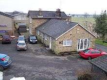
Scotsgap was a stone built railway station in Northumberland on the Wansbeck Railway that served the villages of Scots' Gap and Cambo. It was located on the line between Morpeth and Reedsmouth, and was the junction for the branch line of the Northumberland Railway to Rothbury.
History
In 1859 Parliament authorised the Wansbeck Railway Company to build the line from Morpeth to Reedsmouth. Due to financial difficulties the line was built in stages.[1] In 1862 the line from Morpeth to Scotsgap opened, with an extension to Knowesgate opening a year later. At this time the Wansbeck Railway Company amalgamates with the North British Railway. It was only on 1 May 1865 that the line was completed. In 1923 the line and the North British Railway merged with the London and North Eastern Railway.
The station was opened as Scots Gap in 1862, but was renamed Scotsgap in October 1903. In September 1952 passenger services were withdrawn from the line, and the goods service from much of the line in November 1963. The line was closed completely in the October 1966 with the station being closed on 3 October 1966.[2] The station building and platform remain and the site is now occupied by an agricultural merchant.[3]
| Preceding station | Disused railways | Following station | ||
|---|---|---|---|---|
| Middleton North Line and station closed |
North British Railway Wansbeck Railway |
Knowesgate Line and station closed | ||
| Terminus | North British Railway Rothbury Branch |
Longwitton Line and station closed | ||
| Rothbury Branch | |||||||||||||||||||||||||||||||||||||||||||||||||||||||||
|---|---|---|---|---|---|---|---|---|---|---|---|---|---|---|---|---|---|---|---|---|---|---|---|---|---|---|---|---|---|---|---|---|---|---|---|---|---|---|---|---|---|---|---|---|---|---|---|---|---|---|---|---|---|---|---|---|---|
| |||||||||||||||||||||||||||||||||||||||||||||||||||||||||
Legend | |||||||||||||||||||||||||||||||||||||||||||||||||||||||||
| |||||||||||||||||||||||||||||||||||||||||||||||||||||||||
| Wansbeck Railway |
|---|
Legend |
References
External links
- Scotsgap Station on Northumbrian Railways
- ScotsGap Station on Disused Stations
- Scotsgap Station on a navigable 1956 O. S. map
- The line on RailScot
Coordinates: 55°10′18″N 1°56′27″W / 55.1718°N 1.9409°W