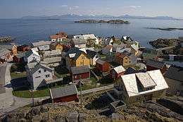
Bolungarvík
| Bolungarvíkurkaupstaður | |
|---|---|
|
Skyline of Bolungarvíkurkaupstaður | |
|
Coat of arms of Bolungarvíkurkaupstaður | |
 Bolungarvíkurkaupstaður | |
| Region | Westfjords |
| Constituency | Northwest Constituency |
| Mayor | Jón Páll Hreinsson |
| Area | 109 km2 (42 sq mi) |
| Population | 882 |
| Density | 872/km2 (2,260/sq mi) |
| Municipal number | 4100 |
| Postal code(s) | 415 |
| Website |
bolungarvik |
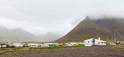

Bolungarvík is a fishing village and municipality in the northwest of Iceland, located at the Westfjords peninsula, approximately 14 kilometres from the town of Ísafjörður and 473 km from the capital city Reykjavík.
It is one of Iceland's oldest fishing outposts, well positioned close to abundant fishing grounds. The quiet countryside attracts some tourists, mainly in summer. Tourist attractions include a camping site next to an indoor swimming pool with a waterside and a National history museum where a polar bear specimen and the biggest bird collection in Iceland can be seen. The surroundings of Bolungarvík are quite popular destinations for hiking, horse riding and birdwatching. Under the right weather conditions, the eastern coast of Greenland can be seen from the summit of Mount Bolafjall. Bolungarvík's faculties include apartment rental, a bank, a post office, two bars, supermarket, convenience store, kindergartens, high school, community center, handcraft store, tourist information centre and a swimming pool downtown.
Bolungarvik was the location for Nói Albínói, a movie by Dagur Kári about a teenager living in a remote Icelandic village who loses his family in an avalanche.
History and folklore
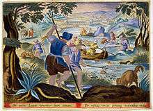
According to Landnámabók Þuríður Sundafyllir settled in Bolungarvík around 940 along with her brother Þjóðólfur. Folklore says they had a disagreement and put a spell on each other, as they were both skilled sorcerers. Þuríður laid on her brother that he would spend eternity as a monolith on which all birds would defecate. Þjóðólfur in turn hexed his sister that she would forever stand where the wind blows most. The pillar that was said to be Þuríður collapsed in half in 1936. The legend says that same night "Þjóðólfur" sank in the sea. That night their spell washed away into the sea.[1]
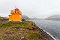 The lighthouse in Bolungarvík Óshólaviti
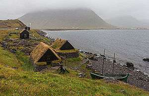 The fishing outpost museum Ósvör
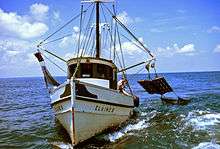
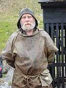 Bolungarvík fisherman
Climate
| Climate data for Galtarviti 14.1 km (8.8 mi) from Bolungarvík | |||||||||||||
|---|---|---|---|---|---|---|---|---|---|---|---|---|---|
| Month | Jan | Feb | Mar | Apr | May | Jun | Jul | Aug | Sep | Oct | Nov | Dec | Year |
| Average high °C (°F) | 1.3 (34.3) |
1.8 (35.2) |
1.1 (34) |
3.6 (38.5) |
6.6 (43.9) |
9.6 (49.3) |
11.2 (52.2) |
11.3 (52.3) |
8.4 (47.1) |
5.6 (42.1) |
3.1 (37.6) |
1.8 (35.2) |
5.4 (41.7) |
| Daily mean °C (°F) | −0.9 (30.4) |
−0.5 (31.1) |
−1.4 (29.5) |
1.0 (33.8) |
4.1 (39.4) |
7.0 (44.6) |
8.7 (47.7) |
8.8 (47.8) |
6.1 (43) |
3.6 (38.5) |
1.0 (33.8) |
−0.6 (30.9) |
3.1 (37.6) |
| Average low °C (°F) | −3.2 (26.2) |
−2.9 (26.8) |
−3.6 (25.5) |
−1.1 (30) |
2.1 (35.8) |
5.1 (41.2) |
6.8 (44.2) |
6.9 (44.4) |
4.2 (39.6) |
1.7 (35.1) |
−1.1 (30) |
−3.0 (26.6) |
1.0 (33.8) |
| Average precipitation mm (inches) | 136.0 (5.354) |
108.7 (4.28) |
115.9 (4.563) |
78.1 (3.075) |
49.7 (1.957) |
51.9 (2.043) |
48.7 (1.917) |
63.7 (2.508) |
124.9 (4.917) |
157.6 (6.205) |
154.9 (6.098) |
124.6 (4.906) |
1,215.4 (47.85) |
| Average precipitation days (≥ 0.1 mm) | 23.7 | 21.0 | 23.9 | 20.0 | 15.4 | 16.1 | 15.1 | 17.0 | 20.1 | 24.5 | 23.7 | 24.5 | 245.3 |
| Source: Veðurstofa Íslands[2] | |||||||||||||
Panorama

References
- ↑ "Jakub Gainski". Vikari. Retrieved 18 July 2012.
- ↑ "1961-1990 Climate Averages for Galtarviti". Veðurstofa Íslands. Retrieved 25 September 2016.
External links
| Wikimedia Commons has media related to Bolungarvík. |
- Official website (Icelandic)