Borda da Mata
| Borda da Mata | |||
|---|---|---|---|
| Municipality | |||
| |||
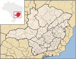 | |||
 Borda da Mata Location in Brazil | |||
| Coordinates: 22°16′26″S 46°09′54″W / 22.27389°S 46.16500°WCoordinates: 22°16′26″S 46°09′54″W / 22.27389°S 46.16500°W | |||
| Country |
| ||
| Region | Southeast | ||
| State | Minas Gerais | ||
| Mesoregion | South and Southwest of Minas Gerais | ||
| Microregion | Pouso Alegre | ||
| Founded | November 24th, 1924 | ||
| Government | |||
| • Mayor | Edmundo Silva Junior | ||
| Area[1] | |||
| • Total | 116,258 sq mi (301,108 km2) | ||
| Elevation | 2,635 ft (803 m) | ||
| Population (2010)[2] | |||
| • Total | 17,129 | ||
| Time zone | BRT (UTC-3) | ||
| • Summer (DST) | BRST (UTC-2) | ||
| HDI (2010) | 0.730 | ||
| Website | Official Website | ||


Borda da Mata is a municipality in Minas Gerais, Brazil.
References
- ↑ "Área territorial oficial" [Official Territorial Area] (in Portuguese). Brazilian Institute of Geography and Statistics (IBGE). 2002-10-10. Retrieved 2011-11-03.
- ↑ "Censo Populacional 2010" (in Portuguese). Instituto Brasileiro de Geografia e Estatística (IBGE). 2010-11-29. Archived from the original on 2011-05-16. Retrieved 2010-12-11.
This article is issued from Wikipedia - version of the 11/6/2016. The text is available under the Creative Commons Attribution/Share Alike but additional terms may apply for the media files.