Boreal Shield Ecozone (CEC)
- This article is about an ecozone. For the landform covering the same region, see Canadian Shield.
The Boreal Shield Ecozone, as defined by the Commission for Environmental Cooperation (CEC), is the largest ecozone in Canada. Covering 1.8 million square kilometres it covers almost 20% of Canada’s landmass, stretching from northern Saskatchewan to Newfoundland.[1]
Formation
Canadian Shield rock forms the nucleus of the North American continent. Other geological structures assumed positions around or on top of the Shield millions of years after it was formed. The Rocky Mountains are relative newcomers on the geological stage. Most Shield rocks were formed well over a billion years earlier, during the very first chapter of the planet's history known as the Precambrian era.
What once may have been a towering mountain chain is today a great rolling plain of ancient bedrock. During the late Precambrian era, fierce convulsions in the Earth’s crust resulted in a warped, collapsed Shield. The foundation of much of the ecozone is now metamorphic gneiss, a highly banded rock formed by intense pressure and heat. Many of the minerals that contribute to the Shield’s economy may have formed during these geologically turbulent times.
During the last ice age, which ended 10 000 years ago, the advance of glaciers continuously plucked and scoured the Boreal Shield, forming striations in the bedrock and carrying large boulders many kilometers. In retreat, massive glaciers enveloped most of the landscape with great amounts of glacial deposits including gravel, sand, shale, and numerous sediments. The vast majority of inadequately drained depressions that were left behind, as well as natural faults in the bedrock, now form the millions of lakes, ponds and wetlands that give this ecozone its distinctive character.[2]
Climate
The regional climate has long, cold winters and short, warm summers, conditions which are moderated in coastal regions. The mean annual temperature ranges from -4 °C in northern Saskatchewan to 5.5 °C in Newfoun
creases from west to east. Permafrost is widespread.[1]
Landforms
The ecozone is characterized by a broadly rolling uplands and lowlands with precambrian granitic bedrock outcrops. There are numerous lakes and rivers, accounting for 22% of Canada’s freshwater surface area.[1] The types of soil vary widely from muskeg to glacial-deposited sands.[3]
Vegetation
The region is widely forested with white and black spruce, balsam fir and jack pine. Deciduous trees are more common in the south, with white birch, trembling aspen and balsam poplar. There are also yellow birch and sugar maple to the east. In areas of muskeg there are stands of black spruce or tamarack. There are frequent forest fires.[1]
Wildlife
Being largely wild and remote, this ecozone is rich in wildlife, including woodland caribou, moose, wolf, black bear, raccoon, marten, fisher, striped skunk, lynx, bobcat and eastern chipmunk. Common birds include boreal owl, great horned owl, blue jay, white-throated sparrow and evening grosbeak. Lakes contain brook char, lake trout, northern pike, perch, and walleye.[3]
-
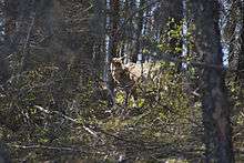
Woodland Caribou on Holt Lake, Manitoba
-
.jpg)
Moose in Gros-Morne National Park, Newfoundland
-
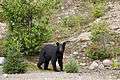
American Black Bear in Quebec
-

Lynx family near Dauphin Manitoba
Off the northern and eastern coasts, aquatic mammals include grey seal, harp seal, hooded seal, ringed seal, sperm whale, orca, Atlantic pilot whale, fin whale, blue whale, northern right whale, bowhead whale, and humpback whale.[4]
Changing conditions
Fire suppression, insect control, clear-cutting and single-species tree farming are widespread in accessible areas. These practices may, over the long term, reduce the diversity of both plant and animal species and increase the forest’s vulnerability to disease.
Many Shield lakes and soils are extremely sensitive to changes in pH. Acid rain from local sources and from the long-range transport of airborne pollutants has already taken an ominous toll. It may be weakening the general vigour and growth rate of trees, as well as of aquatic species, in sensitive areas.[2]
References
- 1 2 3 4 "Boreal Shield". Canadian Atlas Online. Canadian Geographic. Retrieved 7 June 2014.
- 1 2 "Boreal Shield Ecozone: Landforms and Climate". Ecological Framework of Canada. Environment Canada. Retrieved 7 June 2014.
- 1 2 Smith, R.E.; Veldhuis,, H (1998). Terrestrial Ecozones, Ecoregions, and Ecodistricts of Manitoba An Ecological Stratification of Manitoba’s Natural Landscapes (PDF). Winnipeg, Manitoba: Agriculture and Agri-Food Canada. p. 65.
- ↑ Torsten, Bernhardt. "Boreal Shield". Canadian Biodiversity. Torsten Bernhardt. Retrieved 7 June 2014.