Rocky Mountains
| Rocky Mountains | |
|---|---|
|
the Rockies (en), les Rocheuses (fr), Montañas Rocosas, Rocallosas (es) | |
 | |
| Highest point | |
| Peak | Mount Elbert (Colorado, United States) |
| Elevation | 14,440 ft (4,401 m) |
| Coordinates | 39°07′03.90″N 106°26′43.29″W / 39.1177500°N 106.4453583°W |
| Dimensions | |
| Length | 3,000 mi (4,800 km) |
| Geography | |
 | |
| Countries | Canada and United States |
| States/Provinces | |
| Range coordinates | 43°44′N 110°48′W / 43.74°N 110.8°WCoordinates: 43°44′N 110°48′W / 43.74°N 110.8°W |
| Parent range | North American Cordillera |
| Geology | |
| Age of rock | Precambrian and Cretaceous |
| Type of rock | Igneous, Sedimentary and Metamorphic |
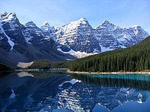
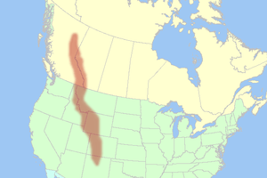
The Rocky Mountains, commonly known as the Rockies, are a major mountain range in western North America. The Rocky Mountains stretch more than 3,000 miles (4,800 km) from the northernmost part of British Columbia, in western Canada, to New Mexico, in the southwestern United States. Within the North American Cordillera, the Rockies are somewhat distinct from the Pacific Coast Ranges and the Cascade Range and Sierra Nevada which all lie further to the west.
The Rocky Mountains were initially formed from 80 million to 55 million years ago during the Laramide orogeny, in which a number of plates began to slide underneath the North American plate. The angle of subduction was shallow, resulting in a broad belt of mountains running down western North America. Since then, further tectonic activity and erosion by glaciers have sculpted the Rockies into dramatic peaks and valleys. At the end of the last ice age, humans started to inhabit the mountain range. After Europeans, such as Sir Alexander Mackenzie, and Americans, such as the Lewis and Clark expedition, started to explore the range, minerals and furs drove the initial economic exploitation of the mountains, although the range itself never became densely populated.
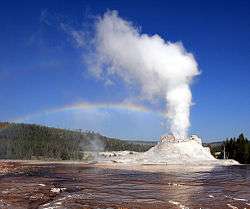
Currently, much of the mountain range is protected by public parks and forest lands, and is a popular tourist destination, especially for hiking, camping, mountaineering, fishing, hunting, mountain biking, skiing, and snowboarding.
Etymology
The name of the mountains is a translation of an Amerindian name that is closely related to Algonquian; the Cree name "as-sin-wati", given as, when seen from across the prairies, they looked like a rocky mass. The first mention of their present name by a European was in the journal of Jacques Legardeur de Saint-Pierre in 1752, where they were called "Montagnes de Roche".[1][2]
Geography
The Rocky Mountains are commonly defined as stretching from the Liard River in British Columbia south to the Rio Grande in New Mexico. Other mountain ranges continue beyond those two rivers, including the Selwyn Mountains in Yukon, the Brooks Range in Alaska, and the Sierra Madre in Mexico, but those are not part of the Rockies, though they are part of the American Cordillera. The United States definition of the Rockies includes the Cabinet and Salish Mountains of Idaho and Montana. Their counterparts north of the Kootenai River, the Columbia Mountains, are considered a separate system in Canada, lying to the west of the huge Rocky Mountain Trench. This runs the length of British Columbia from its beginnings in the middle Flathead River valley in western Montana to the south bank of the Liard River.[3] The Rockies vary in width from 70 to 300 miles (110 to 480 kilometers). Also west of the Rocky Mountain Trench, farther north and facing the Muskwa Range across the trench, are the Stikine Ranges and Omineca Mountains of the Interior Mountains system of British Columbia. A small area east of Prince George, British Columbia on the eastern side of the Trench, the McGregor Plateau, resembles the Rockies but is considered part of the Interior Plateau.
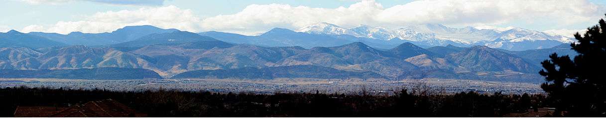
The eastern edge of the Rockies rises dramatically above the Interior Plains of central North America, including the Sangre de Cristo Mountains of New Mexico and Colorado, the Front Range of Colorado, the Wind River Range and Big Horn Mountains of Wyoming, the Absaroka-Beartooth ranges and Rocky Mountain Front of Montana and the Clark Range of Alberta. In Canada geographers define three main groups of ranges: the Continental Ranges, Hart Ranges and Muskwa Ranges (the latter two flank the Peace River, the only river to pierce the Rockies, and are collectively referred to as the Northern Rockies). The Muskwa and Hart Ranges together comprise what is known as the Northern Rockies (the Mackenzie Mountains north of the Liard River are sometimes referred to as being part of the Rocky Mountains but this is an unofficial designation).

The western edge of the Rockies includes ranges such as the Wasatch near Salt Lake City and the Bitterroots along the Idaho-Montana border. The Great Basin and Columbia River Plateau separate these sub-ranges from distinct ranges further to the west, most prominent among which are the Sierra Nevada, Cascade Range and Coast Mountains. The Rockies do not extend into the Yukon or Alaska, or into central British Columbia, where the Rocky Mountain System (but not the Rocky Mountains) includes the Columbia Mountains, the southward extension of which is considered part of the Rockies in the United States. The Rocky Mountain System within the United States is a United States physiographic region; the Rocky Mountain System is known in Canada as the Eastern System.
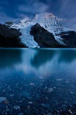
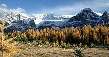
The Rocky Mountains are notable for containing the highest peaks in central North America. The range's highest peak is Mount Elbert located in Colorado at 14,440 feet (4,401 m) above sea level. Mount Robson in British Columbia, at 12,972 feet (3,954 m), is the highest peak in the Canadian Rockies.
The Continental Divide of the Americas is located in the Rocky Mountains and designates the line at which waters flow either to the Atlantic or Pacific Oceans. Triple Divide Peak (8,020 feet (2,440 m)) in Glacier National Park is so named because water that falls on the mountain reaches not only the Atlantic and Pacific, but Hudson Bay as well. Farther north in Alberta, the Athabasca and other rivers feed the basin of the Mackenzie River, which has its outlet on the Beaufort Sea of the Arctic Ocean. See Rivers of the Rocky Mountains for a list of rivers.
Human population is not very dense in the Rocky Mountains, with an average of four people per square kilometer and few cities with over 50,000 people. However, the human population grew rapidly in the Rocky Mountain states between 1950 and 1990. The 40-year statewide increases in population range from 35% in Montana to about 150% in Utah and Colorado. The populations of several mountain towns and communities have doubled in the last 40 years. Jackson Hole, Wyoming, increased 260%, from 1,244 to 4,472 residents, in 40 years.[4]
Geology
The rocks in the Rocky Mountains were formed before the mountains were raised by tectonic forces. The oldest rock is Precambrian metamorphic rock that forms the core of the North American continent. There is also Precambrian sedimentary argillite, dating back to 1.7 billion years ago. During the Paleozoic, western North America lay underneath a shallow sea, which deposited many kilometers of limestone and dolomite.[5]
In the southern Rocky Mountains, near present-day Colorado, these ancestral rocks were disturbed by mountain building approximately 300 Ma, during the Pennsylvanian. This mountain building produced the Ancestral Rocky Mountains. They consisted largely of Precambrian metamorphic rock forced upward through layers of the limestone laid down in the shallow sea.[6] The mountains eroded throughout the late Paleozoic and early Mesozoic, leaving extensive deposits of sedimentary rock.
Terranes started to collide with the western edge of North America in the Mississippian (approximately 350 million years ago), causing the Antler orogeny.[7] For 270 million years, the effects of plate collisions were focused very near the edge of the North American plate boundary, far to the west of the Rocky Mountain region.[7] It was not until 80 Ma that these effects began to reach the Rockies.[8]
The current Rocky Mountains were raised in the Laramide orogeny from between 80 and 55 Ma.[8] For the Canadian Rockies, the mountain building is analogous to a rug being pushed on a hardwood floor:[5] the rug bunches up and forms wrinkles (mountains). In Canada, the terranes and subduction are the foot pushing the rug, the ancestral rocks are the rug, and the Canadian Shield in the middle of the continent is the hardwood floor.[5]
Further south, the growth of the Rocky Mountains in the United States was probably caused by an unusual subduction, where the Farallon plate dove at a shallow angle below the North American plate. This low angle moved the focus of melting and mountain building much farther inland than the normal 200 to 300 miles (300 to 500 km). It is postulated that the shallow angle of the subducting plate greatly increased the friction and other interactions with the thick continental mass above it. Tremendous thrusts piled sheets of crust on top of each other, building the extraordinarily broad, high Rocky Mountain range.[9]
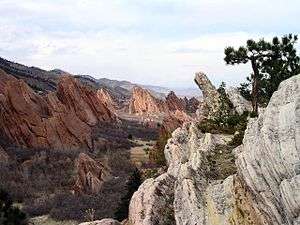
The current southern Rockies were forced upwards through the layers of Pennsylvanian and Permian sedimentary remnants of the Ancestral Rocky Mountains. Such sedimentary remnants were often tilted at steep angles along the flanks of the modern range; they are now visible in many places throughout the Rockies, and are prominently shown along the Dakota Hogback, an early Cretaceous sandstone formation that runs along the eastern flank of the modern Rockies.
Immediately after the Laramide orogeny, the Rockies were like Tibet: a high plateau, probably 6,000 metres (20,000 ft) above sea level. In the last 60 million years, erosion stripped away the high rocks, revealing the ancestral rocks beneath, and forming the current landscape of the Rockies.[5]
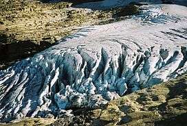
Periods of glaciation occurred from the Pleistocene Epoch (1.8 million - 70,000 years ago) to the Holocene Epoch (fewer than 11,000 years ago). These ice ages left their mark on the Rockies, forming extensive glacial landforms, such as U-shaped valleys and cirques. Recent glacial episodes included the Bull Lake Glaciation that began about 150,000 years ago and the Pinedale Glaciation that probably remained at full glaciation until 15,000-20,000 years ago.[10]
All of the geological processes, above, have left a complex set of rocks exposed at the surface. For example, volcanic rock from the Paleogene and Neogene periods (66 million - 2.6 million years ago) occurs in the San Juan Mountains and in other areas. Millennia of severe erosion in the Wyoming Basin transformed intermountain basins into a relatively flat terrain. The Tetons and other north-central ranges contain folded and faulted rocks of Paleozoic and Mesozoic age draped above cores of Proterozoic and Archean igneous and metamorphic rocks ranging in age from 1.2 billion (e.g., Tetons) to more than 3.3 billion years (Beartooth Mountains).[4]
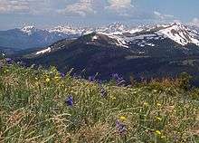
Ecology and climate
There are a wide range of environmental factors in the Rocky Mountains. The Rockies range in latitude between the Liard River in British Columbia (at 59° N) and the Rio Grande in New Mexico (at 35° N). Prairie occurs at or below 1,800 feet (550 m), while the highest peak in the range is Mount Elbert at 14,440 feet (4,400 m). Precipitation ranges from 10 inches (250 mm) per year in the southern valleys[11] to 60 inches (1,500 mm) per year locally in the northern peaks.[12] Average January temperatures can range from 20 °F (−7 °C) in Prince George, British Columbia, to 43 °F (6 °C) in Trinidad, Colorado.[13] Therefore, there is not a single monolithic ecosystem for the entire Rocky Mountain Range.
Instead, ecologists divide the Rocky Mountain into a number of biotic zones. Each zone is defined by whether it can support trees, and the presence of one or more indicator species. Two zones that do not support trees are the Plains and the Alpine tundra. The Great Plains lie to the east of the Rockies, and is characterized by prairie grasses (below roughly 1,800 feet (550 m)). Alpine tundra occurs in regions above the treeline for the Rocky Mountains, which varies from 12,000 feet (3,700 m) in New Mexico to 2,500 feet (760 m) at the northern end of the Rocky Mountains (near the Yukon).[13]
The USGS defines ten forested zones in the Rocky Mountains. Zones in more southern, warmer, or drier areas are defined by the presence of pinyon pines/junipers, ponderosa pines, or oaks mixed with pines. In more northern, colder, or wetter areas, zones are defined by Douglas-firs, Cascadian species (such as western hemlock), lodgepole pines/quaking aspens, or firs mixed with spruce. Near treeline, zones can consist of white pines (such as whitebark pine or bristlecone pine); or a mixture of white pine, fir, and spruce that appear as shrub-like krummholz. Finally, rivers and canyons can create a unique forest zone in more arid parts of the mountain range.[4]

The Rocky Mountains are an important habitat for a great deal of well-known wildlife, such as elk, moose, mule and white-tailed deer, pronghorn, mountain goats, bighorn sheep, badgers, black bears, grizzly bears, coyotes, lynxes, and wolverines.[4] For example, North America's largest herds of moose is in the Alberta-British Columbia foothills forests.
The status of most species in the Rocky Mountains is unknown, due to incomplete information. European-American settlement of the mountains has adversely impacted native species. Examples of some species that have declined include western toads, greenback cutthroat trout, white sturgeon, white-tailed ptarmigan, trumpeter swan, and bighorn sheep. In the United States portion of the mountain range, apex predators such as grizzly bears and gray wolves had been extirpated from their original ranges, but have partially recovered due to conservation measures and reintroduction. Other recovering species include the bald eagle and the peregrine falcon.[4]
History
Indigenous people
Since the last great ice age, the Rocky Mountains were home first to indigenous peoples including the Apache, Arapaho, Bannock, Blackfoot, Cheyenne, Crow Nation, Flathead, Shoshone, Sioux, Ute, Kutenai (Ktunaxa in Canada), Sekani, Dunne-za, and others. Paleo-Indians hunted the now-extinct mammoth and ancient bison (an animal 20% larger than modern bison) in the foothills and valleys of the mountains. Like the modern tribes that followed them, Paleo-Indians probably migrated to the plains in fall and winter for bison and to the mountains in spring and summer for fish, deer, elk, roots, and berries. In Colorado, along the crest of the Continental Divide, rock walls that Native Americans built for driving game date back 5,400–5,800 years. A growing body of scientific evidence indicates that indigenous people had significant effects on mammal populations by hunting and on vegetation patterns through deliberate burning.[4]
European exploration
Recent human history of the Rocky Mountains is one of more rapid change. The Spanish explorer Francisco Vázquez de Coronado—with a group of soldiers, missionaries, and African slaves—marched into the Rocky Mountain region from the south in 1540.[14] The introduction of the horse, metal tools, rifles, new diseases, and different cultures profoundly changed the Native American cultures. Native American populations were extirpated from most of their historical ranges by disease, warfare, habitat loss (eradication of the bison), and continued assaults on their culture.[4]
In 1739, French fur traders Pierre and Paul Mallet, while journeying through the Great Plains, discovered a range of mountains at the headwaters of the Platte River, which local American Indian tribes called the "Rockies", becoming the first Europeans to report on this uncharted mountain range.[15]
.jpg)
Sir Alexander MacKenzie (1764–March 11, 1820) became the first European to cross the Rocky Mountains in 1793.[16] He found the upper reaches of the Fraser River and reached the Pacific coast of what is now Canada on July 20 of that year, completing the first recorded transcontinental crossing of North America north of Mexico.[17] He arrived at Bella Coola, British Columbia, where he first reached saltwater at South Bentinck Arm, an inlet of the Pacific Ocean.
The Lewis and Clark Expedition (1804–1806) was the first scientific reconnaissance of the Rocky Mountains.[18] Specimens were collected for contemporary botanists, zoologists, and geologists. The expedition was said to have paved the way to (and through) the Rocky Mountains for European-Americans from the East, although Lewis and Clark met at least 11 European-American mountain men during their travels.[4]
Mountain men, primarily French, Spanish, and British, roamed the Rocky Mountains from 1720 to 1800 seeking mineral deposits and furs. The fur-trading North West Company established Rocky Mountain House as a trading post in what is now the Rocky Mountain Foothills of present-day Alberta in 1799, and their business rivals the Hudson's Bay Company established Acton House nearby.[19] These posts served as bases for most European activity in the Canadian Rockies in the early 19th century. Among the most notable are the expeditions of David Thompson (explorer), who followed the Columbia River to the Pacific Ocean.[20] On his 1811 expedition, he camped at the junction of the Columbia River and the Snake River and erected a pole and notice claiming the area for the United Kingdom and stating the intention of the North West Company to build a fort at the site.[21]
By the Anglo-American Convention of 1818, which established the 49th parallel north as the international boundary west from Lake of the Woods to the "Stony Mountains";[22] the UK and the USA agreed to what has since been described as "joint occupancy" of lands further west to the Pacific Ocean. Resolution of the territorial and treaty issues, the Oregon dispute, was deferred until a later time.
In 1819, Spain ceded their rights north of the 42nd Parallel to the United States, though these rights did not include possession and also included obligations to Britain and Russia concerning their claims in the same region.
Settlement
After 1802, American fur traders and explorers ushered in the first widespread Caucasian presence in the Rockies south of the 49th parallel. The more famous of these include Americans William Henry Ashley, Jim Bridger, Kit Carson, John Colter, Thomas Fitzpatrick, Andrew Henry, and Jedediah Smith. On July 24, 1832, Benjamin Bonneville led the first wagon train across the Rocky Mountains by using South Pass in the present State of Wyoming.[4] Similarly, in the wake of Mackenzie's 1793 expedition, fur trading posts were established west of the Northern Rockies in a region of the northern Interior Plateau of British Columbia which came to be known as New Caledonia, beginning with Fort McLeod (today's community of McLeod Lake) and Fort Fraser, but ultimately focused on Stuart Lake Post (today's Fort St. James).
Negotiations between the United Kingdom and the United States over the next few decades failed to settle upon a compromise boundary and the Oregon Dispute became important in geopolitical diplomacy between the British Empire and the new American Republic. In 1841 James Sinclair, Chief Factor of the Hudson's Bay Company, guided some 200 settlers from the Red River Colony west to bolster settlement around Fort Vancouver in an attempt to retain the Columbia District for Britain. The party crossed the Rockies into the Columbia Valley, a region of the Rocky Mountain Trench near present-day Radium Hot Springs, British Columbia, then traveled south. Despite such efforts, in 1846, Britain ceded all claim to Columbia District lands south of the 49th parallel to the United States; as resolution to the Oregon boundary dispute by the Oregon Treaty.[23]
Thousands passed through the Rocky Mountains on the Oregon Trail beginning in the 1840s.[24] The Mormons began to settle near the Great Salt Lake in 1847.[25] From 1859 to 1864, gold was discovered in Colorado, Idaho, Montana, and British Columbia, sparking several gold rushes bringing thousands of prospectors and miners to explore every mountain and canyon and to create the Rocky Mountains' first major industry. The Idaho gold rush alone produced more gold than the California and Alaska gold rushes combined and was important in the financing of the Union Army during the American Civil War. The transcontinental railroad was completed in 1869,[26] and Yellowstone National Park was established as the world's first national park in 1872.[27] Meanwhile, a transcontinental railroad in Canada was originally promised in 1871. Though political complications pushed its completion to 1885, the Canadian Pacific Railway eventually followed the Kicking Horse and Rogers Passes to the Pacific Ocean.[28] Canadian railway officials also convinced Parliament to set aside vast areas of the Canadian Rockies as Jasper, Banff, Yoho, and Waterton Lakes National Parks, laying the foundation for a tourism industry which thrives to this day. Glacier National Park (MT) was established with a similar relationship to tourism promotions by the Great Northern Railway.[29] While settlers filled the valleys and mining towns, conservation and preservation ethics began to take hold. U.S. President Harrison established several forest reserves in the Rocky Mountains in 1891–92. In 1905, U.S. President Theodore Roosevelt extended the Medicine Bow Forest Reserve to include the area now managed as Rocky Mountain National Park. Economic development began to center on mining, forestry, agriculture, and recreation, as well as on the service industries that support them. Tents and camps became ranches and farms, forts and train stations became towns, and some towns became cities.[4]
Economy
Industry and development
Economic resources of the Rocky Mountains are varied and abundant. Minerals found in the Rocky Mountains include significant deposits of copper, gold, lead, molybdenum, silver, tungsten, and zinc. The Wyoming Basin and several smaller areas contain significant reserves of coal, natural gas, oil shale, and petroleum. For example, the Climax mine, located near Leadville, Colorado, was the largest producer of molybdenum in the world. Molybdenum is used in heat-resistant steel in such things as cars and planes. The Climax mine employed over 3,000 workers. The Coeur d'Alene mine of northern Idaho produces silver, lead, and zinc. Canada's largest coal mines are near Fernie, British Columbia and Sparwood, British Columbia; additional coal mines exist near Hinton, Alberta, and in the Northern Rockies surrounding Tumbler Ridge, British Columbia.[4]
Abandoned mines with their wakes of mine tailings and toxic wastes dot the Rocky Mountain landscape. In one major example, eighty years of zinc mining profoundly polluted the river and bank near Eagle River in north-central Colorado. High concentrations of the metal carried by spring runoff harmed algae, moss, and trout populations. An economic analysis of mining effects at this site revealed declining property values, degraded water quality, and the loss of recreational opportunities. The analysis also revealed that cleanup of the river could yield $2.3 million in additional revenue from recreation. In 1983, the former owner of the zinc mine was sued by the Colorado Attorney General for the $4.8 million cleanup costs; five years later, ecological recovery was considerable.[30]
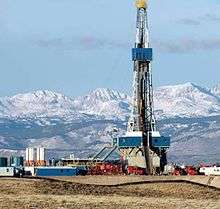
The Rocky Mountains contain several sedimentary basins that are rich in coalbed methane. Coalbed methane is natural gas that arises from coal, either through bacterial action, or through exposure to high temperature. Coalbed methane supplies 7 percent of the natural gas used in the United States. The largest coalbed methane sources in the Rocky Mountains are in the San Juan Basin in New Mexico and Colorado and the Powder River Basin in Wyoming. These two basins are estimated to contain 38 trillion cubic feet of gas. Coalbed methane can be recovered by dewatering the coal bed, and separating the gas from the water; or injecting water to fracture the coal to release the gas (so-called hydraulic fracturing).[31]
Agriculture and forestry are major industries. Agriculture includes dryland and irrigated farming and livestock grazing. Livestock are frequently moved between high-elevation summer pastures and low-elevation winter pastures, a practice known as transhumance.[4]
Tourism

See also: List of U.S. Rocky Mountain ski resorts, List of Alberta ski resorts, List of B.C. ski resorts
Every year the scenic areas and recreational opportunities of the Rocky Mountains draw millions of tourists.[4] The main language of the Rocky Mountains is English. But there are also linguistic pockets of Spanish and indigenous languages. French is another official language in Canada's national parks.
People from all over the world visit the sites to hike, camp, or engage in mountain sports. In the summer season, examples of tourist attractions are:
In the United States:
- Pikes Peak
- Royal Gorge
- Cumbres and Toltec Scenic Railroad
- Rocky Mountain National Park
- Yellowstone National Park
- Grand Teton National Park
- Glacier National Park
- Sawtooth National Recreation Area
In Canada, the mountain range contains these national parks:
- Banff National Park
- Jasper National Park
- Kootenay National Park
- Waterton Lakes National Park
- Yoho National Park
Glacier National Park in Montana and Waterton Lakes National Park in Alberta border each other and collectively are known as Waterton-Glacier International Peace Park. (See also International Peace Park.)
In the winter, skiing is the main attraction. A list of the major ski resorts can be found at List of U.S. Rocky Mountain ski resorts.
The adjacent Columbia Mountains in British Columbia contain major resorts such as Panorama and Kicking Horse, as well as Mount Revelstoke National Park and Glacier National Park.
There are numerous provincial parks in the British Columbia Rockies, the largest and most notable being Mount Assiniboine Provincial Park, Mount Robson Provincial Park, Northern Rocky Mountains Provincial Park, Kwadacha Wilderness Provincial Park, Stone Mountain Provincial Park and Muncho Lake Provincial Park.
See also
- Outline of North America
- Mountain ranges of the world
- Rocky Mountains
- Little Rocky Mountains
- Mountain man
- The Rocky Mountain Rangers (Canadian militia unit)
References
- ↑ Akrigg, G. P. V.; Akrigg, Helen B. (1997). British Columbia Place Names (3rd ed.). Vancouver, BC: UBC Press. p. 229. ISBN 0774806362. Retrieved 2 September 2015.
- ↑ Mardon, Ernest G.; Mardon, Austin A. (2010). Community Place Names of Alberta (3rd ed.). Edmonton, AB: Golden Meteorite Press. p. 283. ISBN 9781897472170. Retrieved 2 September 2015.
- ↑ Cannings, Richard (2007). The Rockies: A Natural History. Greystone/David Suzuki Foundation. p. 5. ISBN 9781553652854.
- 1 2 3 4 5 6 7 8 9 10 11 12 13
 This article incorporates public domain material from the United States Geological Survey document: T.J. Stohlgren. "Rocky Mountains".
 - 1 2 3 4 Gadd, Ben (2008). "Geology of the Rocky Mountains and Columbias". Archived from the original (PDF) on 2012-04-20. Retrieved 2010-01-01.
- ↑ Chronic, Halka (1980). Roadside Geology of Colorado. ISBN 0-87842-105-X.
- 1 2 Blakely, Ron. "Geologic History of Western US".
- 1 2 English, Joseph M.; Johnston, Stephen T. (2004). "The Laramide Orogeny: What Were the Driving Forces?" (PDF). International Geology Review. 46 (9): 833 838. doi:10.2747/0020-6814.46.9.833.
- ↑ This article incorporates public domain material from the United States Geological Survey document: "Geologic Provinces of the United States: Rocky Mountains". Retrieved 2006-12-10.
- ↑ Pierce, K. L. (1979). History and dynamics of glaciation in the northern Yellowstone National Park area. Washington, D.C: U.S. Geological Survey. pp. 1 90. Professional Paper 729-F.
- ↑ "Southern Rocky Mountains". Forest Encyclopedia Network. Retrieved 2010-08-22.
- ↑ "Northern Rocky Mountains". Forest Encyclopedia Network. Retrieved 2010-08-22.
- 1 2 Sheridan, Scott. "US & Canada: Rocky Mountains (Chapter 14)" (PDF). Geography of the United States and Canada course notes. Kent State University. Archived from the original (PDF) on 2006-09-01.
- ↑ "Events in the West (1528-1536)". 2001. Retrieved 15 April 2012.
- ↑ "The West: Events from 1650 to 1800". PBS.
- ↑ "Mackenzie: 1789, 1792-1797". Retrieved 15 April 2012.
- ↑ "First Crossing of North America National Historic Site of Canada". Retrieved 15 April 2012.
- ↑ "Lewis and Clark Expedition: Scientific Encounters". Retrieved 15 April 2012.
- ↑ "Rocky Mountain House National Historic Site of Canada". 28 Feb 2012. Retrieved 15 April 2012.
- ↑ "Guide to the David Thompson Papers 1806-1845". 2006. Retrieved 15 April 2012.
- ↑ Oldham, kit (23 Jan 2003). "David Thompson plants the British flag at the confluence of the Columbia and Snake rivers on July 9, 1811.". Retrieved 15 April 2012.
- ↑ "Treaties in Force" (PDF). 1 November 2007. Retrieved 15 April 2012.
- ↑ "Historical Context and American Policy". Archived from the original on 2012-07-07. Retrieved 15 April 2012.
- ↑ "Oregon Trail Interpretive Center". Retrieved 15 April 2012.
- ↑ "The Mormon Trail". Retrieved 15 April 2012.
- ↑ "The Transcontinental Railroad". 2012. Retrieved 15 April 2012.
- ↑ "Yellowstone National Park". 4 April 2012. Retrieved 15 April 2012.
- ↑ "Canadian Pacific Railway". Archived from the original on 2012-07-07. Retrieved 15 April 2012.
- ↑ "Glaciers and Glacier National Park". 2011. Retrieved 15 April 2012.
- ↑ Brandt, E. (1993). "How much is a gray wolf worth?". National Wildlife. 31: 412.
- ↑ "Coal-Bed Gas Resources of the Rocky Mountain Region". USGS. USGS fact sheet 158-02.
Further reading
- Baron, Jill (2002). Rocky Mountain futures: an ecological perspective. Island Press. ISBN 1-55963-953-9
- Newby, Rick (2004). The Rocky Mountain region. Greenwood Press. ISBN 0-313-32817-X
External links
- Colorado Rockies Forests ecoregion images at bioimages.vanderbilt.edu (slow modem version)
- North Central Rockies Forests ecoregion images at bioimages.vanderbilt.edu (slow modem version)
- South Central Rockies Forests ecoregion images at bioimages.vanderbilt.edu (slow modem version)
- Sunset on the Top of the Rocky Mountains, CO, Historical Society of Pennsylvania