Borujen
| Boroujen بروجن Borojen | |
|---|---|
|
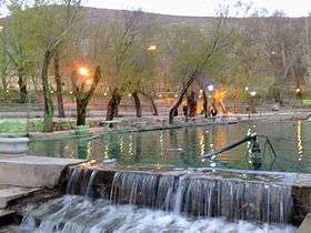
Siasard Touristic Area (at Sunset, Summer time) | |
 Boroujen Location in Iran | |
| Coordinates: 31°57′55″N 51°17′14″E / 31.96528°N 51.28722°ECoordinates: 31°57′55″N 51°17′14″E / 31.96528°N 51.28722°E | |
| Country |
|
| Province | Chaharmahal and Bakhtiari Province |
| County | Borujen County |
| Bakhsh | Central |
| Government | |
| • Mayor | Mohammadali Shafi'zadeh |
| Elevation[1] | 2,197 m (7,208 ft) |
| Population (2006) | |
| • Total | 49,077 |
| Time zone | IRST (UTC+3:30) |
| • Summer (DST) | IRDT (UTC+4:30) |
| Area code(s) | 382 |
| Website | http://broujencity.ir |
Borujen (Persian: بروجن, also Romanized as Borojen, Borūjen, Boroojen; also known as Urjen, or Oorjen)[2] is a city in and capital of Borujen County, Chaharmahal and Bakhtiari Province, Iran. At the 2006 census, its population was 49,077, in 12,828 families.[3]
Its geographical situation makes it a critical junction between south-west and central parts of the country, thus provoking the industrial growth of the region.
History
The exact foundation date is not well known. However, based on the most ancient graveyard found in the city dating back to 1596 AD (1004 Hijri Qamari [4]), one can calculate the date in which the people started to live in the region.
The date in which the popoultion becomes centralized in the region and the first municipality was created comes back to the Constitutional Revolution in which the Saad ad-Daula has gathered in the city with his forces to depart to invade Esfahan and then Tehran.
Weather and Climate
Boroujen is well known by its extremely cold weather, usually mentioned as one of the coldest Iran cities in national weather forecasts. It is located on an altitude of about 2197 m from sea levels. Its climate is usually combined of moderate summer climates as well as very cold winters. Snow days are normally 122 days per year, and the temperature could reach -27 °C. The maximum observed temperature has been 36 °C. Average annular precipitation is 243 mm (24% in the spring, 1% in the summer, 33% in the fall, and 44% in the winter).
Boroujen has one of the highest elevation among all Iran cities, making it rich and fruitful in terms of vegetable and animal environment.
| Climate data for Boroujen | |||||||||||||
|---|---|---|---|---|---|---|---|---|---|---|---|---|---|
| Month | Jan | Feb | Mar | Apr | May | Jun | Jul | Aug | Sep | Oct | Nov | Dec | Year |
| Average high °C (°F) | 12.0 (53.6) |
15.0 (59) |
20.0 (68) |
23.0 (73.4) |
29.0 (84.2) |
30.0 (86) |
35.0 (95) |
35.0 (95) |
31.0 (87.8) |
26.0 (78.8) |
18.0 (64.4) |
11.0 (51.8) |
19.9 (67.8) |
| Average low °C (°F) | −14.0 (6.8) |
−8.0 (17.6) |
−7.0 (19.4) |
−3.0 (26.6) |
2.0 (35.6) |
5.0 (41) |
11.0 (51.8) |
7.0 (44.6) |
2.0 (35.6) |
1.0 (33.8) |
−6.0 (21.2) |
−15.0 (5) |
1.1 (34) |
| Source: chaharmahalmet.ir [5] | |||||||||||||
The city is located in a valley with the same name which has a total area of 580 m² in the eastern part of Chahar Mahaal and Bakhtiari province.
_square%2C_Borujen%2C_Iran.jpg) Moallem (Teacher) Square, Buali Boulevard
Moallem (Teacher) Square, Buali Boulevard Elahieh District
 Mosalla Bridge (A Historical Bridge)
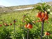 Inverted Tulips, Siasard Area
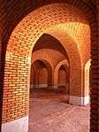 Mosalla Bridge
 Boroujen-Isfahan Road
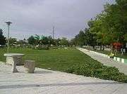 A Park in the City
Colleges and universities
Borujen hosts several higher education institutes:
- Payam-e-Noor University of Boroujen (Persian)
- Islamic Azad University of Boroujen (Persian)
- Nursing Faculty of Boroujen (Persian)
- Boroujen Technical School (Persian)
References
- ↑ http://www.chaharmahalmet.ir/stations.asp
- ↑ Borujen can be found at GEOnet Names Server, at this link, by opening the Advanced Search box, entering "-3056915" in the "Unique Feature Id" form, and clicking on "Search Database".
- ↑ "Census of the Islamic Republic of Iran, 1385 (2006)". Islamic Republic of Iran. Archived from the original (Excel) on 2011-11-11.
- ↑ Persian Studies
- ↑ "Regional Weather Forecast".
External links
| Wikimedia Commons has media related to Borujen. |
| Capital | 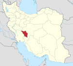 | ||||||||||||||||||||||||||
|---|---|---|---|---|---|---|---|---|---|---|---|---|---|---|---|---|---|---|---|---|---|---|---|---|---|---|---|
| Counties and cities | |||||||||||||||||||||||||||
| Landmarks |
| ||||||||||||||||||||||||||
| populated places | |||||||||||||||||||||||||||
| Capital | |||||||||||||||||||||||||||||||||||||||||||
|---|---|---|---|---|---|---|---|---|---|---|---|---|---|---|---|---|---|---|---|---|---|---|---|---|---|---|---|---|---|---|---|---|---|---|---|---|---|---|---|---|---|---|---|
| Districts |
| ||||||||||||||||||||||||||||||||||||||||||