County of Brabant
| County of Brabant | ||||||||||
| Graafschap Brabant (nl) Comté de Brabant (fr) | ||||||||||
| State of the Holy Roman Empire | ||||||||||
| ||||||||||
|
| ||||||||||
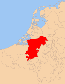
 Map of the Hapsburg Netherlands. The Landgraviate of Brabant (1085) was centred on Brussels (Bruxelles), and grew into the Duchy of Brabant (yellow) after 1183. The red line approximates part of the current border between Belgium and the Netherlands. | ||||||||||
| Capital | Brussels | |||||||||
| Languages | Brabantian, Walloon | |||||||||
| Government | Feudal monarchy | |||||||||
| Historical era | Middle Ages, Renaissance | |||||||||
| • | Established | 1085 | ||||||||
| • | Disestablished | 1183 | ||||||||
| ||||||||||
The County of Brabant (1085–1183) was a small medieval area of land located west of Brussels, between the Dender and Zenne rivers in the Low Countries, part of the Holy Roman Empire.
Before 1085 the land had belonged to Hermann II, Count Palatine of Lotharingia. Upon his death, Emperor Henry IV assigned this fief to Henry III, Count of Louvain (Leuven) and Count of Brussels, as the Landgraviate of Brabant. This is the earliest known use of the term Landgrave.
In 1183 Frederick Barbarossa elevated the Landgrave, Henry I, to be Duke of Brabant; the lands of the Counts of Louvain and Brussels and of the Landgrave of Brabant were merged in the Duchy of Brabant.
The area made up part of South Brabant from 1815 to 1830 as part of the United Kingdom of the Netherlands, and part of the Belgian Province of Brabant from 1830 to 1996. It is currently in the western part of Flemish Brabant in the Flemish Region of Belgium.
Further reading
- Frans J. Van Droogenbroeck, Het landgraafschap Brabant (1085-1183) en zijn paltsgrafelijke voorgeschiedenis. De territoriale en institutionele aanloop tot het ontstaan van het hertogdom Brabant (2004)