Bramhope
| Bramhope | |
 Bramhope crossroads |
|
 Bramhope |
|
| Population | 3,400 [1] |
|---|---|
| OS grid reference | SE253432 |
| – London | 175 mi (282 km) SSE |
| Civil parish | Bramhope |
| Metropolitan borough | City of Leeds |
| Metropolitan county | West Yorkshire |
| Region | Yorkshire and the Humber |
| Country | England |
| Sovereign state | United Kingdom |
| Post town | LEEDS |
| Postcode district | LS16 |
| Dialling code | 0113 |
| Police | West Yorkshire |
| Fire | West Yorkshire |
| Ambulance | Yorkshire |
| EU Parliament | Yorkshire and the Humber |
| UK Parliament | Leeds North West |
Coordinates: 53°52′58″N 1°36′34″W / 53.8829°N 1.6095°W
Bramhope is a village and civil parish in the City of Leeds metropolitan borough, West Yorkshire, England, north of Holt Park and north east of Cookridge.
The village is 9 miles (14 km) north of Leeds city centre. According to the 2001 census the parish had a population of 3,400[1] and it is in the LS16 Leeds postcode area. The population had increased to 3,533 at the 2011 Census.[2] It is predominantly made up of large, privately owned houses which tend to be above the average value for properties in West Yorkshire.
Bramhope is in the Leeds North West constituency; its Member of Parliament is Liberal Democrat Greg Mulholland, who won the seat from Labour in the 2005 general election.
History
The earliest known settlement in the area was a British camp established off Moor Road. The Romans built a road through the area from Adel to Ilkley, traces of which remain in a field near Leeds Bradford Airport.[3]
The place-name Bramhope appears first in the Domesday Book as "Bra(m)hop", with later medieval spellings including Bramhop(a) and Bramhop(p)e. The name seems to derive from Old English brōm 'broom' + hōp 'a small valley, side-valley off a larger valley', here referring to a small valley off Wharfedale.[4] In 1086, Bramhope was the manor of an Anglo-Saxon thegn, Uchill. In 1095 the manor passed to Percy family, and in 1165 was sold to Ralph de Bramhope. In the 13th century the monasteries owned much of the land and had granges where sheep were grazed. The monks used tracks, such as Scotland Lane and Staircase Lane, as they travelled from their outlying granges to Kirkstall Abbey.[3]
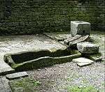
The village had a small population until the 20th century. The Black Death of 1348-09 reduced the number of adults to 34, but this gradually increased to about 400 in 1900. Now it is approximately 3,400.[3] Water was drawn from private wells or the town well at the foot of Northgate (now Church Hill). The town well was restored in 1991 by the Bramhope History Group, and is located opposite St Giles Church.[3] The plaque says that the well was exposed in 1991, so perhaps it had been lost for some time.[5]
Churches
At the Dissolution of the Monasteries Henry VIII gave the land to the Earl of Cumberland. In the 16th century the Dyneley family moved into the area and acquired Bramhope Hall. In 1649 they built the Puritan Chapel, which was taken over by the Church of England after the Restoration.[3] The chapel is one of only a few built during the Commonwealth period. It is said not to have been consecrated but nevertheless was regularly used for church services until 1881-82. The Puritan Chapel was listed Grade I in 1966.
When the chapel proved too small for the growing population, St Giles' Church was built in 1881.[6] The original Methodist chapel was built in 1837 and replaced by the much bigger church in 1896.[3][7] There is a map showing the location of St Giles and the Methodist church here. Bramhope Cemetery, established in 1861, is in Moor Road,[8] but there are still some historical gravestones remaining in the cemetery of the Puritan Chapel.
Road and railway
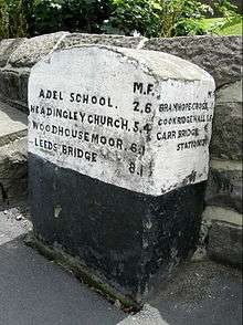
For many centuries travellers to the market towns in the vicinity used Otley Old Road. However, it was the Leeds to Otley turnpike road, with its tollhouses, opened in 1842, which routed travellers through the outskirts of Bramhope. It is along this route that motorists today travel between Leeds and the northwest. The milestones along the road were erected in 1850.[3]
The railway was excavated under the village through the Bramhope Tunnel constructed between 1845 and 1849. The tunnel has an elaborate castellated northern entrance and there are many heaps of spoil and several ventilation shafts along its length. There is a replica of the tunnel entrance in Otley churchyard, erected as a memorial to those who lost their lives during the tunnel's construction.[3] There is no Bramhope railway station.
Schools
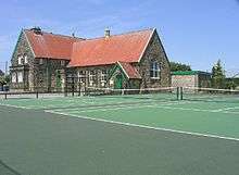
A village school was built in Eastgate where the war memorial garden is situated. A plaque states "On this site in 1790 a Day School was erected by the freeholders and copyholders of Bramhope Township. It was also used as a Sunday School and Public Meeting Place. Demolished 1961". The school became overcrowded whilst tunnelling work for the railway was going on in the late 1840s. It was replaced by a larger building in 1873 in Breary Lane, next to the shopping parade. The present school, situated on Tredgold Crescent, was opened in 1961.[3]
Community
Bramhope has a Round Table, which organises activities to raise money for charity.[9] Bramhope has a cricket club.[10][11] Chevin Music Centre is based at Bramhope Primary School in the village.[12]
Memorial hall
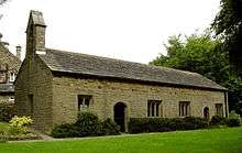
The large, red-roofed Robert Craven Memorial Hall, (originally the Craven Institute) 1896, was part of the bequest of Robert Craven, a local farmer. It is now the village hall and administered as a registered charity. It has a crown bowling green, car park and tennis courts. Inside there are various rooms plus a large hall with stage, which doubles as a badminton court.[13] On the second Saturday of every month a farmer's market is hosted at this hall.[14] The memorial hall also hosts a yearly flower show in the autumn,[15] and a bridge club.[16]
Listed buildings in Bramhope

- Grade I buildings: Puritan Chapel, Otley Road (north side).[17]
- Grade II buildings: Farmhouse at 1 Church Hill;[18] Barn about 5 metres west of Old Manor Farmhouse;[19] Old Manor Farmhouse (rear portion only);[20] Weaver's Cottage, 4 Eastgate;[21] Methodist Church, Eastgate, north side;[22] Gazebo on northeast corner of garden of Belvedere, Hall Drive (south side);[23] Manor House, Manor Close (north side);[24] Sighting tower, south side of Moorland Road;[25] The Hollies, Old Lane (north side);[26] Portal to north entrance to Bramhope railway tunnel.[27]
- Grade II Mileposts: Milepost on east corner of junction with Church Hill and Ditley Road (south side);[28] Milepost at SE 240 441, Otley Road (north side);[29] Milepost at SE 253 432, Otley Road (north side);[30] Milepost at SE 264 421, Otley Road (north side);[31] Milepost on east corner of junction with Breary Lane at SE 255 430, Otley Road (south side);[32] Milepost on east corner of junction with Breary lane east at SE 256 430, Otley road (north side);[33] Milepost on south-east corner of junction with Pool Bank New Road at SE 241 440, Otley Road (south side);[34] Milepost on south-west corner of junction with Pool Bank New Road st SE 241440, Otley Road (south side);[35] Milepost on west corner of junction with Creskeld Lane at SE 258 428, Otley Road (north side).[36]
- Related Grade II listing at Otley: Memorial to victims of Bramhope tunnel disaster (sic), Church Lane (north side), Otley.[37]
Notable people
- Gold medal Winner at London 2012 Alistair Brownlee and Bronze medal winning brother Jonathan Brownlee[38]
Gallery
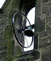 Bell on Puritan Church, 1649
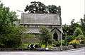 St Giles Church, 1881
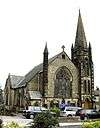 Methodist Church, 1896
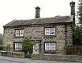 Old smithy, 1687
 Old manor farm house, 1691
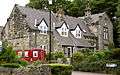 Old school house 1873, now flats
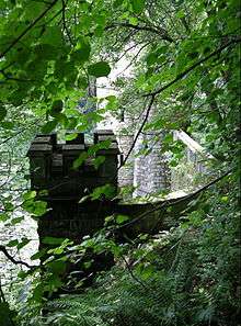 Bramhope Tunnel, north portal, 1845–49
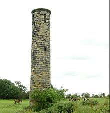 Sighting tower over Bramhope Tunnel route, 1845–49
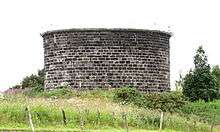 Ventilation shaft serving Bramhope Tunnel, 1845–49
 Ventilation shaft in centre of Bramhope, 1845–49
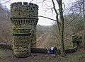 One of the Bramhope Tunnel's distinctive castellated towers.
Location grid
 |
Arthington | | ||
| Yeadon | |
Harewood | ||
| ||||
| | ||||
| Adel |
References
- 1 2 "Parish Headcounts, 2001", Bramhope CP (Parish), Office for National Statistics. Retrieved 17 March 2015
- ↑ "Civil Parish population 2011". Neighbourhood Statistics. Office for National Statistics. Retrieved 25 February 2016.
- 1 2 3 4 5 6 7 8 9 "Bramhope and Carlton Parish Council". A Brief History of Bramhope (source:A History of the Township of Bramhope' by W.F. Seals). 10 October 2000. Retrieved 14 July 2009.
- ↑ Victor Watts (ed.), The Cambridge Dictionary of English Place-Names, Based on the Collections of the English Place-Name Society (Cambridge: Cambridge University Press, 2004), s.v. BRAMHOPE.
- ↑ Hatton, Gordon (19 January 2009). "Geograph.org.uk". Photo of Old Well, Bramhope, and comments. Retrieved 14 July 2009.
- ↑ "St Giles Bramhope". St Giles Church website. 2009. Retrieved 2009-07-14.
- ↑ "Bramhope Methodist Church". Bramhope Methodist Church website. 2009. Retrieved 14 July 2009.
- ↑ "Bramhope and Carlton Parish Council". Bramhope Cemetery. 2005. Retrieved 14 July 2009.
- ↑ "bramhope844.co.uk". Bramhope Round Table. 2009. Retrieved 14 July 2009.
- ↑ Riding, Steve (1 July 2009). "Rothwell Today". Slideshow: Bramhope C C V Oulton CC. Retrieved 14 July 2009.
- ↑ "Bramhope CC". Bramhope Cricket Club website. 2009. Retrieved 14 July 2009.
- ↑ "Chevin Music Centre". Chevin Music Centre. Retrieved 29 July 2011.
- ↑ Firth, Graham (2001). "Bramhope Parish Council". The Robert Craven Memorial Hall. Retrieved 14 July 2009.
- ↑ "Bramhope Parish Council". Farmers Market. 2008. Retrieved 14 July 2009.
- ↑ "Bramhope Parish Council". Bramhope flower show. 2009. Retrieved 14 July 2009.
- ↑ "gfirth.plus.com". Bramhope Bridge Club. 2009. Retrieved 14 July 2009.
- ↑ "English Heritage National Monuments Record". Puritan Chapel, Otley Road (north side). Retrieved 14 July 2009.
- ↑ "English Heritage National Monuments Record". Farmhouse, 1 Church Hill. Retrieved 14 July 2009.
- ↑ "English Heritage National Monuments Record". Barn approx 5 metres west of Old Manor Farmhouse. Retrieved 14 July 2009.
- ↑ "English Heritage National Monuments Record". Old Manor Farmhouse (rear portion only). Retrieved 14 July 2009.
- ↑ "English Heritage National Monuments Record". Weaver's Cottage, 4 Eastgate. Retrieved 14 July 2009.
- ↑ "English Heritage National Monuments Record". Methodist church, Eastgate, north side. Retrieved 14 July 2009.
- ↑ "English Heritage National Monuments Record". Gazebo on northwest corner of garden of Westwood, Hall drive. Retrieved 14 July 2009.
- ↑ "English Heritage National Monuments Record". Manor House, Manor Close (north side). Retrieved 14 July 2009.
- ↑ "English Heritage National Monuments Record". Sighting tower, south side of Moorland Road. Retrieved 14 July 2009.
- ↑ "English Heritage National Monuments Record". The Hollies, Old Lane, north side. Retrieved 14 July 2009.
- ↑ "English Heritage National Monuments Record". Portal to north entrance to Bramhope railway tunnel. Retrieved 14 July 2009.
- ↑ "English Heritage National Monuments Record". Milestone at Church Hill and Ditley Road junction. Retrieved 14 July 2009.
- ↑ "English Heritage National Monuments Record". Milepost at SE 240 441, Otley Road (north side). Retrieved 14 July 2009.
- ↑ "English Heritage National Monuments Record". Milepost at SE 253 432, Otley Road (north side). Retrieved 14 July 2009.
- ↑ "English Heritage National Monuments Record". Milepost at SE 264 421, Otley Road (north side). Retrieved 14 July 2009.
- ↑ "English Heritage National Monuments Record". Milepost on east corner of junction with Breary Lane at SE 255 430, Otley Road (south side). Retrieved 14 July 2009.
- ↑ "English Heritage National Monuments Record". Milepost on east corner of junction with Breary lane east at SE 256 430, Otley road (north side). Retrieved 14 July 2009.
- ↑ "English Heritage National Monuments Record". Milepost on south-east corner of junction with Pool Bank New Road at SE 241 440, Otley Road (south side). Retrieved 14 July 2009.
- ↑ "English Heritage National Monuments Record". Milepost on south-west corner of junction with Pool Bank New Road st SE 241440, Otley Road (south side). Retrieved 14 July 2009.
- ↑ "English Heritage National Monuments Record". Milepost on west corner of junction with Creskeld Lane at SE 258 428, Otley Road (north side). Retrieved 14 July 2009.
- ↑ "English Heritage National Monuments Record". Memorial to victims of Bramhope tunnel disaster, Church Lane (north side), Otley. Retrieved 14 July 2009.
- ↑ "Brownlee postbox row hits Leeds suburbs". BBC News. 10 August 2012. Retrieved 23 December 2015.
External links
 Media related to Bramhope at Wikimedia Commons
- Media related to Bramhope Tunnel at Wikimedia Commons
- The ancient parish of Otley: historical and genealogical information at GENUKI (Bramhope was in this parish).
- Flickr: Set of images of Bramhope Tunnel