Branahuie
| Branahuie | |
| Scottish Gaelic: Bràigh na h-Aoidhe | |
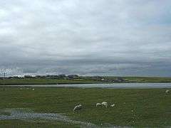 Loch Bràigh na h-Aoidhe, looking towards Melbost |
|
 Branahuie |
|
| Language | Scottish Gaelic |
|---|---|
| English | |
| OS grid reference | NB468321 |
| Civil parish | Stornoway |
| Council area | Na h-Eileanan Siar |
| Lieutenancy area | Western Isles |
| Country | Scotland |
| Sovereign state | United Kingdom |
| Post town | ISLE OF LEWIS |
| Postcode district | HS2 |
| Dialling code | 01851 |
| Police | Scottish |
| Fire | Scottish |
| Ambulance | Scottish |
| EU Parliament | Scotland |
| UK Parliament | Na h-Eileanan an Iar |
| Scottish Parliament | Na h-Eileanan an Iar |
Coordinates: 58°12′22″N 6°18′32″W / 58.206°N 6.309°W
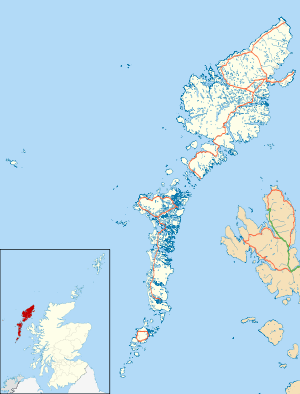
Branahuie (Scottish Gaelic: Bràigh na h-Aoidhe) is a village on Lewis in the Outer Hebrides, Scotland. Branahuie is within the parish of Stornoway,[1] and is situated on the A866.[2][3] It is also close to Stornoway, Stornoway Airport and Melbost.
References
- ↑ "Details of Branahuie". Scottish Places. Retrieved 27 December 2014.
- ↑ "9.1 St Columba's Church, Isle of Lewis". Slí Cholmcille. Retrieved 27 December 2014.
- ↑ "Black Rabbits of Lewis". Pine Martens. Retrieved 27 December 2014.
External links
| Wikimedia Commons has media related to Branahuie. |
- Visitor's guide for the Island of Lewis
- Website of the Western Isles Council with links to other resources
- Disabled access to Lewis for residents and visitors
- 1911 Encyclopædia Britannica article on Lewis and Harris
- A Guide to living in the Outer Hebrides, with most information pertaining to Lewis
| Inhabited islands | ||
|---|---|---|
| Other islands | ||
| Settlements |
| |
| Districts | ||
| Geographical features | ||
| Historical sites | ||
This article is issued from Wikipedia - version of the 2/16/2016. The text is available under the Creative Commons Attribution/Share Alike but additional terms may apply for the media files.