Bridgehampton, New York
| Bridgehampton, New York | |
|---|---|
| Hamlet and census-designated place | |
|
| |
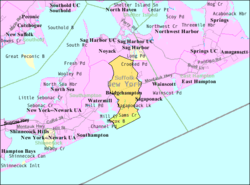 U.S. Census map | |
 Bridgehampton U.S. Census map | |
| Coordinates: 40°55′59″N 72°18′29″W / 40.93306°N 72.30806°WCoordinates: 40°55′59″N 72°18′29″W / 40.93306°N 72.30806°W | |
| Country | United States |
| State | New York |
| County | Suffolk |
| Area | |
| • Total | 13.6 sq mi (35.3 km2) |
| • Land | 13.0 sq mi (33.7 km2) |
| • Water | 0.6 sq mi (1.6 km2) |
| Elevation | 43 ft (13 m) |
| Population (2010) | |
| • Total | 1,756 |
| • Density | 130/sq mi (50/km2) |
| Time zone | Eastern (EST) (UTC-5) |
| • Summer (DST) | EDT (UTC-4) |
| ZIP code | 11932 |
| Area code(s) | 631 |
| FIPS code | 36-08136 |
| GNIS feature ID | 0944725 |
Bridgehampton is a hamlet and census-designated place (CDP) in the South Fork of Suffolk County, New York, USA. The population was 1,756 at the 2010 census.[1]
Bridgehampton is in the town of Southampton, on Long Island. Shortly after the founding of Southampton in 1640, settlers began to move east to the area known by the Shinnecock Indians as Sagaponack and Mecox. At the head of Sagg Pond the hardy settlers established a community called Bullhead, later renamed Bridgehampton—after the bridge built across the pond. Sagg Bridge was built in 1686 by Ezekiel Sandford. The bridge was the link between Mecox and Sagaponack and gave this locality its name of Bridgehampton. The notorious criminal and memoirist Stephen Burroughs lived there during the 18th century and helped found the town's first library in 1793; the volumes he purchased could be found in the Bridgehampton Public Library as late as 2002.[2]
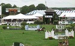
Bridgehampton became the home of the horse show known as the Hampton Classic and a road racing course that figured prominently in American automobile racing.
Demographics for the CDP
As of the census[3] of 2000, there were 1,381 people, 627 households, and 369 families residing in the CDP. The population density was 147.8 per square mile (57.1/km²). There were 1,494 housing units at an average density of 159.9/sq mi (61.8/km²). The racial makeup of the CDP was 78.86% White, 17.38% African American, 0.51% Native American, 0.80% Asian, 1.45% from other races, and 1.01% from two or more races. Hispanic or Latino of any race were 3.26% of the population.
There were 627 households out of which 19.6% had children under the age of 18 living with them, 47.0% were married couples living together, 7.5% had a female householder with no husband present, and 41.1% were non-families. 33.0% of all households were made up of individuals and 12.9% had someone living alone who was 65 years of age or older. The average household size was 2.20 and the average family size was 2.82.
In the CDP the population was spread out with 17.7% under the age of 18, 4.1% from 18 to 24, 22.2% from 25 to 44, 33.2% from 45 to 64, and 22.9% who were 65 years of age or older. The median age was 49 years. For every 100 females there were 95.3 males. For every 100 females age 18 and over, there were 94.0 males.
The median income for a household in the CDP was $54,896, and the median income for a family was $74,583. Males had a median income of $50,865 versus $32,778 for females. The per capita income for the CDP was $43,781. About 6.8% of families and 8.5% of the population were below the poverty line, including 19.2% of those under age 18 and 2.7% of those age 65 or over.
Geography
Bridgehampton is located at 40°55′59″N 72°18′29″W / 40.93306°N 72.30806°W (40.933182, -72.307987).[4]
According to the United States Census Bureau, the CDP has a total area of 13.6 square miles (35.3 km2), of which 13.0 square miles (33.7 km2) is land and 0.62 square miles (1.6 km2), or 4.57%, is water.[1]
| Climate data for Bridgehampton, New York (1981–2010 normals, extremes 1930–present) | |||||||||||||
|---|---|---|---|---|---|---|---|---|---|---|---|---|---|
| Month | Jan | Feb | Mar | Apr | May | Jun | Jul | Aug | Sep | Oct | Nov | Dec | Year |
| Record high °F (°C) | 67 (19) |
63 (17) |
79 (26) |
92 (33) |
93 (34) |
95 (35) |
102 (39) |
100 (38) |
94 (34) |
88 (31) |
75 (24) |
70 (21) |
102 (39) |
| Average high °F (°C) | 38.9 (3.8) |
40.5 (4.7) |
47.0 (8.3) |
56.3 (13.5) |
66.1 (18.9) |
75.2 (24) |
81.0 (27.2) |
80.2 (26.8) |
73.5 (23.1) |
63.2 (17.3) |
53.7 (12.1) |
43.8 (6.6) |
60.0 (15.6) |
| Daily mean °F (°C) | 31.3 (−0.4) |
33.0 (0.6) |
39.0 (3.9) |
47.9 (8.8) |
57.1 (13.9) |
66.7 (19.3) |
72.5 (22.5) |
71.7 (22.1) |
64.8 (18.2) |
54.2 (12.3) |
45.6 (7.6) |
36.2 (2.3) |
51.7 (10.9) |
| Average low °F (°C) | 23.8 (−4.6) |
25.5 (−3.6) |
31.0 (−0.6) |
39.6 (4.2) |
48.2 (9) |
58.3 (14.6) |
64.0 (17.8) |
63.2 (17.3) |
56.0 (13.3) |
45.1 (7.3) |
37.5 (3.1) |
28.6 (−1.9) |
43.4 (6.3) |
| Record low °F (°C) | −11 (−24) |
−12 (−24) |
4 (−16) |
14 (−10) |
29 (−2) |
36 (2) |
45 (7) |
41 (5) |
35 (2) |
22 (−6) |
10 (−12) |
−6 (−21) |
−12 (−24) |
| Average precipitation inches (mm) | 4.04 (102.6) |
3.67 (93.2) |
5.07 (128.8) |
4.52 (114.8) |
3.79 (96.3) |
4.14 (105.2) |
3.45 (87.6) |
4.02 (102.1) |
4.60 (116.8) |
4.10 (104.1) |
4.37 (111) |
4.37 (111) |
50.14 (1,273.6) |
| Average snowfall inches (cm) | 7.7 (19.6) |
8.3 (21.1) |
5.2 (13.2) |
0.9 (2.3) |
0.0 (0) |
0.0 (0) |
0.0 (0) |
0.0 (0) |
0.0 (0) |
0.0 (0) |
0.7 (1.8) |
4.0 (10.2) |
26.8 (68.1) |
| Average precipitation days (≥ 0.01 in) | 9.9 | 8.9 | 10.2 | 10.5 | 10.7 | 8.9 | 7.9 | 7.7 | 8.1 | 8.4 | 9.5 | 10.0 | 110.7 |
| Average snowy days (≥ 0.1 in) | 3.4 | 2.9 | 2.0 | 0.3 | 0.0 | 0.0 | 0.0 | 0.0 | 0.0 | 0.0 | 0.2 | 1.7 | 10.5 |
| Source: NOAA[5][6] | |||||||||||||
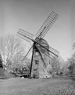 Beebe windmill, moved from Sag Harbor to Bridgehampton in the 19th century
Schools
Race circuit
The Bridgehampton Race Circuit was a 2.85-mile (4.59 km), thirteen-turn road course located near Sag Harbor. The historic road racing track has been converted to a golf course and homes.[7]
Notable people
- Beyoncé and husband Jay Z rented a $43.5 million property in Bridgehampton. [8]
- A.J. Pierzynski - American Baseball Player
- Carl Yastrzemski, Boston Red Sox, 1967 Triple Crown winner, was born and raised in Bridgehampton
- Roger Bennett, soccer journalist and host of the Men in Blazers podcast
- Madonna, (singer)
- Esteban Vincente - Artist - Lived in Bridgehampton, New York
See also
References
- 1 2 "Geographic Identifiers: 2010 Demographic Profile Data (G001): Bridgehampton CDP, New York". U.S. Census Bureau, American Factfinder. Retrieved 2012-12-24.
- ↑ Susanna Ashton, "A Corrupt Medium: Stephen Burroughs and the Bridgehampton, New York Library," Libraries & Culture 38 (Spring 2003), 93-119.
- ↑ "American FactFinder". United States Census Bureau. Archived from the original on 2013-09-11. Retrieved 2008-01-31.
- ↑ "US Gazetteer files: 2010, 2000, and 1990". United States Census Bureau. 2011-02-12. Retrieved 2011-04-23.
- ↑ "NowData - NOAA Online Weather Data". National Oceanic and Atmospheric Administration. Retrieved July 29, 2016.
- ↑ "NY Bridgehampton". National Oceanic and Atmospheric Administration. Retrieved July 29, 2016.
- ↑ Bridgehampton Race Circuit Archived February 11, 2007, at the Wayback Machine.
- ↑ "Hamptons mansion Jay-Z and Beyoncé rented last summer can be yours for just $43million". Retrieved 12 August 2015.
External links
| Wikimedia Commons has media related to Bridgehampton, New York. |
- Bridgehampton Racing Heritage Group
- Susanna Ashton, "A Corrupt Medium: Stephen Burroughs and the Bridgehampton, New York Library," Libraries & Culture 38 (Spring 2003), 93-119.