British Kaffraria
| British Kaffraria | |||||
| Colony of the British Empire | |||||
| |||||
 | |||||
| Capital | King William's Town[1] | ||||
| History | |||||
| • | Established | 1835 | |||
| • | Disestablished | 1866 | |||
| Population | |||||
| • | 1858[2] | 52,535 | |||
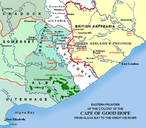
British Kaffraria was a British colony/subordinate administrative entity in present-day South Africa, consisting of the districts now known as King Williams Town and East London.
It was inhabited primarily by the Ngqika ("Gaika") people, the major branch of the Rharhabe Xhosa.
Naming and Etymology
The term Kaffraria stems from the word "Kaffir" - originally an Arabic term which was used for the Black African inhabitants of southern Africa. The word Kaffraria came to refer specifically to the Xhosa lands in what is now the Eastern Cape. Later, the western Xhosa lands which fell under British rule came to be known as "British Kaffraria", while the independent Xhosa territory to the east was known simply as "Kaffraria".
A subsection of British Kaffraria was later reconstituted by the Apartheid regime as the semi-independent homeland of Ciskei.
History
Similar to elsewhere in southern Africa, the aboriginal inhabitants of the area were the Khoisan hunter gatherers and herders. Early on, these peoples were displaced by the Bantu expansion, when it crossed the Kei river from the north. The area was consolidated under the rule of a branch of the Xhosa people.
Xhosa rule
The native Xhosa people were ruled by the Ngqika ("Gaika") Chiefs (part of the Rarabe offshoot of the main Xhosa line):
- Ngqika (the founding Chief), 1797 - 13 November 1829
- Sandile, 13 November 1829 - 1 June 1878
British rule
The territory came under British rule in the 19th century. However, there was great disagreement on how it should be governed, with the Cape Colony being reluctant to take responsibility for its administration. Its status therefore changed several times before it finally became part of the Cape Colony.
"Queen Adelaide Province" in the Cape Colony (1835)
After the 6th Frontier War ("Hintsa's War"), on 10 May 1835, the area was seized by the British Governor Sir Benjamin d'Urban, and annexed to the Cape Colony as Queen Adelaide Province. A location for the new province's government was selected, and named King William’s Town. The province was declared to be for the settlement of loyal African tribes, those rebel tribes who agreed to replace their leadership, and the Fengu (known to the Europeans as the "Fingo people"), who had recently arrived fleeing from the Zulu armies and had been living under Xhosa subjection. Magistrates were appointed to administer the territory in the hope that they would gradually, with the help of missionaries, undermine tribal authority.
A separate "Queen Adelaide Land district" (1836-1847)
Only a few months after its forcible joining to the Cape Colony, on 5 December 1835, the Cape Colony disallowed the annexation. The province's creation was also condemned by London, as being uneconomical and unjust.
Queen Adelaide was formally disannexed in December 1836, the Cape's border was re-established back at the Keiskamma river, and new treaties were made with the chiefs responsible for order beyond the Fish River. The area was now renamed Queen Adelaide Land district, with Grahamstown as its capital. Indigenous rule by and large re-established itself in much of the territory and the land remained a separate entity until 1847.[3]
"British Kaffraria" in the Cape Colony (1847-1866)
After the 7th Frontier War ("Amatola War"), on 17 December 1847, the area was again seized by the new British Governor Harry Smith, and again annexed to the Cape Colony, this time as the British Kaffraria Colony, with King William's Town as its capital. The new Governor re-occupied the abandoned forts and British Imperial troops were moved into the territory.[4]
German emigrants arrived in British Kaffraria in 1858-1859, and again in 1877-1878.[5]
A separate "British Kaffraria" Crown Colony (1860-1866)
On 7 March 1860, in the wake of the great Xhosa cattle-killing, the Cape Colony again dis-annexed British Kaffraria, and it became a separate crown colony. A separate Lieutenant Governor, Colonel John Maclean, was appointed to administer the colony. However economic problems threatened to bankrupt the colony and pressure was brought upon the neighbouring Cape Colony once again to take on the territory and its expenses.
Final Annexation to the Cape Colony (1866)
It was finally re-incorporated into the Cape Colony on 17 April 1866.
From 1853 to 1866 the territory used the stamps of the Cape of Good Hope, the mail being sent from Port Elizabeth or overland from the Cape.
The area eventually formed the basis of the Ciskei independent homeland.
Administrative chiefs
The successive administrative chiefs, with repeatedly changed styles, were:
- Administrator Harry Smith, 10 May 1835 - 5 December 1835
- Lieutenant-governors:
- Harry Smith (acting), 10 December 1835 - 13 September 1836
- Sir Andries Stockenstroom, 13 September 1836 - 9 August 1838
- John Hare, 9 August 1838 - September 1846 (acting to 31 August 1839)
- Under direct rule from Cape Colony, September 1846 - 9 April 1847
- Sir Henry Young, 9 April 1847 - 4 November 1847
- Direct rule from Cape Colony, 4 November 1847 - 17 December 1847
- Chief Commissioners:
- George Henry Mackinnon, 23 December 1847 - October 1852
- John Mclean, October 1852 - 7 March 1860
- Lieutenant-governor (again): John Mclean, 7 March 1860 - 24 December 1864
- Governor's Deputy: Robert Graham, 24 December 1864 - 17 April 1866
See also
References
- ↑ Henry Hall (F.R.G.S.) (1859). Manual of South African Geography. S. Solomon. p. 43. Retrieved 2013-07-24.
- ↑ Henry Hall (F.R.G.S.) (1859). Manual of South African Geography. S. Solomon. p. 46. Retrieved 2013-07-24.
- ↑ "Conquest of the Eastern Cape 1779-1878 | South African History Online". Sahistory.org.za. Retrieved 2012-11-18.
- ↑ "7th Frontier War 1846-1847". Makana Tourism. Retrieved 2015-03-03.
- ↑ Spanuth, Johannes (1914). British Kaffraria and its German Settlements. München and Leipzig: Duncker and Humblot - World Digital Library. Retrieved 2015-03-03.
External links
- British Kaffraria and its German Settlements (English) (German)
Coordinates: 32°53′S 27°24′E / 32.883°S 27.400°E