Broad Channel (IND Rockaway Line)
| Broad Channel | |||||||||
|---|---|---|---|---|---|---|---|---|---|
| New York City Subway rapid transit station | |||||||||
|
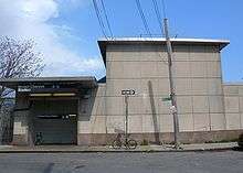
Broad Channel station after the post-Hurricane Sandy renovation | |||||||||
| Station statistics | |||||||||
| Address |
Noel Road & West Road Queens, NY 11693 | ||||||||
| Borough | Queens | ||||||||
| Locale | Broad Channel | ||||||||
| Coordinates | 40°36′31″N 73°48′58″W / 40.608618°N 73.816°WCoordinates: 40°36′31″N 73°48′58″W / 40.608618°N 73.816°W | ||||||||
| Division | B (IND, formerly LIRR Rockaway Beach Branch) | ||||||||
| Line | IND Rockaway Line | ||||||||
| Services |
A S | ||||||||
| Transit connections |
| ||||||||
| Structure | At-grade | ||||||||
| Platforms | 2 side platforms | ||||||||
| Tracks | 2 | ||||||||
| Other information | |||||||||
| Opened | 1880 (LIRR station)[1] | ||||||||
| Closed | 1950 (LIRR station) | ||||||||
| Rebuilt | June 28, 1956 (as a Subway station) | ||||||||
| Accessibility | Same-platform wheelchair transfer available | ||||||||
| Traffic | |||||||||
| Passengers (2015) |
91,766[2] | ||||||||
| Rank | 421 out of 422 | ||||||||
| Station succession | |||||||||
| Next north |
Howard Beach – JFK Airport: A (Terminal): S | ||||||||
| Next south |
Beach 67th Street (Far Rockaway): A Beach 90th Street (Rockaway Park): A | ||||||||
| |||||||||
| |||||||||


Broad Channel is a station on the IND Rockaway Line of the New York City Subway, located in the neighborhood of the same name at Noel and West Roads in the borough of Queens. It is served by the A train and the Rockaway Park Shuttle at all times, the latter of which originates/terminates here.
History
The station originally opened in 1880 as a New York, Woodhaven and Rockaway Railroad station (although some sources claim it opened in June 1881), that was acquired by the Long Island Rail Road and became a station on the Rockaway Beach Branch. As a Long Island Rail Road station it served as one of two junctions between the Far Rockaway and Rockaway Beach Branches. The other junction was at Hammels Station, although it was originally a junction for the Far Rockaway Branch and the Ocean Electric Railway. Wooden shelter sheds were added to the station in 1921 and 1923.[3] A fire on the trestle between this station and another one known as The Raunt forced the closure of both stations on May 23, 1950, as well as the entire Jamaica Bay trestle.[4][5][6]
By October 3, 1955, the entire Rockaway Beach Branch south of Ozone Park, and all of the Far Rockaway Branch west of Far Rockaway was purchased by the New York City Transit Authority. The Broad Channel station was entirely reconstructed (as were the Howard Beach and Far Rockaway stations) with new concrete platforms, and a new station house. The contract for the new station was approved in December 1954.[7][8][9][10] The station opened to subway service on June 28, 1956.[6]
In 1985, the station had only 224 paying daily riders on a typical weekday in 1985 not counting farebeaters, making it one of the least used stations in the system.[11]
The station and the adjacent segment of the Rockaway Line suffered serious damage during Hurricane Sandy in 2012, and was out of service for several months. Due to its location in the middle of Jamaica Bay, the station was filled with debris, with its trackbed damaged.[12][13] During its temporary closure, the station received new ADA-tactile strips, platform edge rubbing boards, and cosmetic and mechanical work. Service was restored to the station on May 30, 2013.[14]
Station layout
| M | Mezzanine | Crossover |
| P Platform level |
Side platform, doors will open on the right | |
| Northbound | ← ← | |
| Southbound | → → | |
| Side platform, doors will open on the right | ||
| G | Street level station house | Exit/ Entrance, station agent, MetroCard vending machines, fare control |
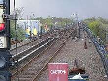
This station has two tracks and two side platforms, each measuring 12 feet (3.7 m) wide and over 660 feet (200 m) long.[7] The platforms are sheltered with canopies and windscreens.[7] A station house is located above both platforms, containing a crossover, waiting area and fare control.[7][15] The single street staircase outside of fare control goes down to West Road (previously known as West 104th Street) by the intersection of Noel Road (originally 194th Avenue) next to the Rockaway-bound platform.[7][16][17] This platform also has a set of exit-only turnstiles leading directly to this staircase so riders exiting the station on this side do not have to go through the station house. The station house is heated, while the platforms feature passenger-activated heaters;[18] these heaters, and the doors separating the station house and staircases, were not originally part of the station.[19][20] The station house originally had 1950s-era signage at its front entrance reading "SUBWAY",[17] but now only has modern MTA entrance signs.
At the north end of station is a power substation, located at West Road and East 6th Road (originally 192nd Avenue) adjacent to the Rockaway-bound platform.[7][15][17] A second exit-only staircase is located here, but is closed.[15] Just to the north, the Rockaway Line gains two extra non-revenue tracks straddling the two revenue tracks; the western track is a test track, installed in 2001 and called the Far Rockaway Test Track,[21][22][23][24][25] while the eastern track is used to relay shuttle trains.[18] The western track extends around 10,000 feet (3,000 m) or 2 miles (3.2 km),[21] while eastern track is long enough for one full-length train and ends at a bumper block. Continuing north, the Rockaway Line crosses Jamaica Bay before reaching Howard Beach; the distance of 3.5 miles (5.6 km) between the two stations is the longest between any two in the New York City Subway system.[21] To the south, the Rockaway Line continues to the Rockaway peninsula, where it splits at Hammels Wye to allow service to both Far Rockaway – Mott Avenue and Rockaway Park – Beach 116th Street.[18] Punch boxes are located at the ends of both platforms, to allow train operators to select the correct route.[26]
Broad Channel is a small island with fewer than 3,000 residents,[27] and the station has the second-lowest ridership in the subway system as of 2015. It was only trailed by a closed station, making Broad Channel the least used of any fully operating subway station in the city.[28] However, it is the only transfer point between the A train and the Rockaway Park Shuttle, and most riders use it in this capacity.[18][19][28]
Nearby points of interest include a visitor center and trails for the Gateway National Recreation Area's Jamaica Bay Wildlife Refuge.[16][17]
Gallery
 Before renovation
.jpg) During renovation
During renovation.jpg) Renovation almost complete
Renovation almost complete.jpg) Reopening
Reopening
References
- ↑ Long Island Rail Road History Website — The NY, Woodhaven and Rockaway RR
- ↑ "Facts and Figures: Annual Subway Ridership". Metropolitan Transportation Authority. Retrieved 2016-04-19.
- ↑ LIRR Station History (TrainsAreFun.com)
- ↑ "L.I.R.R. Propses Junking Trestle Ruined by Fire". Brooklyn Daily Eagle. May 31, 1950. p. 4. Retrieved 22 September 2015 – via Newspapers.com.
- ↑ Bresiger, Gregory (July 18, 2012). "The Trains Stopped Running Here 50 Years Ago". qgazette.com. Queens Gazette. Retrieved 3 July 2015.
- 1 2 Freeman, Ira Henry (June 28, 1956). "Rockaway Trains to Operate Today". nytimes.com. The New York Times. Retrieved 29 June 2015.
- 1 2 3 4 5 6 "$7,000,000 Signal Job To Be Let In February: City Approves $1,000,000 Contracts For Station And Sub-Station in Broad Channel And For The Rehabilitation Of The Liberty Avenue Line" (PDF). Wave of Long Island. Fultonhistory.com. December 23, 1954. p. 1. Retrieved 22 July 2016.
- ↑ "$7,000,000 Signal Job To Be Let In February: City Approves $1,000,000 Contracts For Station And Sub-Station in Broad Channel And For The Rehabilitation Of The Liberty Avenue Line" (PDF). Wave of Long Island. Fultonhistory.com. December 23, 1954. p. 7. Retrieved 22 July 2016.
- ↑ "New Station Set At Howard Beach". nytimes.com. The New York Times. November 11, 1954. Retrieved 29 June 2015.
- ↑ "New Look In Transit: Modernistic Station And Drawbridge" (PDF). Wave of Long Island. Fultonhistory.com. December 2, 1954. p. 1. Retrieved 16 August 2016.
- ↑ Levine, Richard (1986-11-05). "COLUMN ONE: TRANSPORT". The New York Times. ISSN 0362-4331. Retrieved 2016-10-02.
- ↑ "Rebuilding the Rockaways After Hurricane Sandy". mta.info. Metropolitan Transportation Authority. Archived from the original on 2012-11-29. Retrieved 18 November 2012.
- ↑ Chaban, Matt (November 11, 2012). "Broad Channel Crossing Must Be Rebuilt, Leaving Rockaways Without A-Train for Months or Longer". New York Observer. Retrieved 22 July 2016.
- ↑ "A Train Service Restored to Rockaways". Metropolitan Transportation Authority. May 30, 2013.
- 1 2 3 New York City Transit Authority (November 1, 1954). "Architectural Drawing of Broad Channel Station: IND Rockaway Line". New York Transit Museum. Retrieved 25 August 2016.
- 1 2 "MTA Neighborhood Maps: The Rockaways" (PDF). mta.info. Metropolitan Transportation Authority. 2015. Retrieved 6 July 2015.
- 1 2 3 4 "Broad Channel: a future land use proposal" (PDF). New York City Department of City Planning. August 1962. Retrieved 22 July 2016.
- 1 2 3 4 "Review of the A and C Lines" (PDF). Metropolitan Transportation Authority. December 11, 2015. Retrieved 19 January 2016.
- 1 2 "Zero Weather, Token Limit Accelerate Subway Gripes" (PDF). Wave of Long Island. Fultonhistory.com. January 11, 1968. p. 1. Retrieved 22 July 2016.
- ↑ "Zero Weather, Token Limit Accelerate Subway Gripes" (PDF). Wave of Long Island. Fultonhistory.com. January 11, 1968. p. 4. Retrieved 22 July 2016.
- 1 2 3 "Rebuilding the Rockaways After Hurricane Sandy: The Recovery". Metropolitan Transportation Authority. May 16, 2013. Retrieved 27 July 2016.
- ↑ Tarrant, Colin (April 1, 2004). "Kinetic energy storage wins acceptance". Railway Gazette International. Retrieved 27 July 2016.
- ↑ "EPRI-DOE Handbook of Energy Storage for Transmission & Distribution Applications: Final Report, December 2003" (PDF). Electric Power Research Institute, United States Department of Energy. December 2003. Retrieved 27 July 2016.
- ↑ "BATTERY POWER SYSTEM FOR TRACKSIDE ENERGY STORGE Final Repor" (PDF). New York State Energy Research and Development Authority, Kawasaki Heavy Industries Rolling Stock Company, Kawasaki Heavy Industries. October 2010. Retrieved 27 July 2016.
- ↑ "Handbook of Energy Storage for Transmission or Distribution Applications: Technical Update, December 2002" (PDF). Electric Power Research Institute. December 2002. Retrieved 27 July 2016.
- ↑ Rosenfeld, Robbie (May 30, 2013). "Photo of punch box on northbound platform". nycsubway.org. Retrieved 27 August 2016.
- ↑ Khan, Kulsoom (March 31, 2016). "Broad Channel". Queens Tribune. Retrieved 22 July 2016.
- 1 2 "Safest and riskiest areas of New York's subway system revealed in Daily News investigation". New York Daily News. June 22, 2014. Retrieved March 18, 2016.
External links
| Wikimedia Commons has media related to Broad Channel (IND Rockaway Line). |
- nycsubway.org – IND Rockaway: Broad Channel
- Station Reporter — Rockaway Park Shuttle
- The Subway Nut - Broad Channel Pictures
- Entrance from Google Maps Street View
- Platforms from Google Maps Street View
| Former services | ||||
| Preceding station | Following station | |||
|---|---|---|---|---|
toward Grand Street | Rockaway Beach Branch | toward Rockaway Park |
||