Broadway (IND Crosstown Line)
| Broadway | |||||||
|---|---|---|---|---|---|---|---|
| New York City Subway rapid transit station | |||||||
|
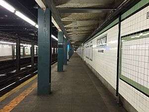
Queens bound platform | |||||||
| Station statistics | |||||||
| Address |
Broadway & Union Avenue Brooklyn, NY 11206 | ||||||
| Borough | Brooklyn | ||||||
| Locale | Williamsburg | ||||||
| Coordinates | 40°42′20″N 73°57′01″W / 40.705433°N 73.950219°WCoordinates: 40°42′20″N 73°57′01″W / 40.705433°N 73.950219°W | ||||||
| Division | B (IND) | ||||||
| Line | IND Crosstown Line | ||||||
| Services |
G | ||||||
| Transit connections |
| ||||||
| Structure | Underground | ||||||
| Platforms | 2 side platforms | ||||||
| Tracks | 2 | ||||||
| Other information | |||||||
| Opened | July 1, 1937[1] | ||||||
| Traffic | |||||||
| Passengers (2015) |
1,313,362[2] | ||||||
| Rank | 326 out of 422 | ||||||
| Station succession | |||||||
| Next north |
Metropolitan Avenue: G | ||||||
| Next south |
Flushing Avenue: G | ||||||
| |||||||
| |||||||
Broadway is a station on the IND Crosstown Line of the New York City Subway. Located at the intersection of Broadway and Union Avenue in Williamsburg, Brooklyn, it is served at all times by the G train.
Station layout
| G | Street Level | Entrances/Exits |
| M | Mezzanine | to entrances/exits, station agent, MetroCard vending machines |
| P Platform level |
Side platform, doors will open on the right | |
| Northbound | ← | |
| Southbound | → | |
| Side platform, doors will open on the right | ||
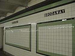
This underground station opened on July 1, 1937, as part of the extension of the Crosstown Line from Nassau Avenue to Hoyt-Schermerhorn Streets.[1] This station has two tracks and two side platforms.[3] The platforms have a green trim line on a black border and name tablets reading "BROADWAY" in white sans serif lettering on a black background and green border. The i-beam columns in the entire station are dark blue with alternating ones on the platforms having the standard black station name plate in white lettering.
Small station signs underneath the trim line read "BROADWAY" in white lettering on a black background. One of the icon tiles on the northbound platform is incorrectly spelled as "BRODAWAY"; this mistake may have been part of the station's original tilework.[4][5][6][7] After the Daily News and several other news outlets reported on the misspelling in February 2009,[4][5][6] the two wrong letters were covered with the correct ones printed on stickers, but as of December 2009, the stickers have been removed. In December 2011, the MTA stated the tiles would remain.[6][7]
The station has a small mezzanine above the platforms and tracks at the south end, allowing a free transfer between directions. Two staircases from each platform go up to the mezzanine.[3] The mezzanine previously had a northern half that had exits to both northern corners of Johnson Avenue and Union Avenue,[8] and the intersection of Union Avenue, South 5th Street, and Montrose Avenue (the north end of the station). It is now closed to the public and currently holds offices and storage space.[9][8] A turnstile bank provides entrance/exit from the station. Outside fare control, there is a token booth and four street stairs, one to the southwest corner of Broadway and Heyward Street, and the remaining three to the southwestern, southeastern, and northeastern corners of Broadway and Union Avenue;[10] however, the staircase to the southwestern corner was closed many years back.[11]
The BMT Jamaica Line lies directly above the staircases to this station; Lorimer Street and Hewes Street are located to the east and west of the entrances, respectively. However, there is no permanent free transfer between either of those stations and this one, in spite of requests from riders and transit advocacy groups.[12][13][14]
Despite the lack of a free transfer, temporary free transfers have been offered during construction or service disruptions,[12] most recently from July 25, 2014 to September 2, 2014 between Lorimer Street and this station, due to the closure of the IND Crosstown Line under the Newtown Creek for tunnel repairs.[12][15][16]
Unfinished station
The north end of the Broadway station has been blocked by false walls and is used as storage. This northern third of the platform level area consists of closed transfer passages that are sealed behind doors and fences. These passages lead to an unfinished station shell on an upper level, provisionally called South Fourth Street, which is accessible by passages that would have become stairs. The shell was built as part of a planned expansion of the Independent Subway System.[8][17][18]
The station is a semi-complete shell with four island platforms and six track beds, having the same layout as Hoyt–Schermerhorn Streets station. No rails, tiles, lights, or stairs were built.[19] The unfinished station, which is only about as long as Union Avenue is wide, was designed to be the main transfer point from the proposed Worth Street and Houston Street Lines coming from Manhattan with the Crosstown Line. These lines would have become two major trunk lines going east. One line would have gone towards the proposed Utica Avenue Line and the other line towards the Myrtle Avenue – Central Avenue Line to the Rockaways.[8][17][20]
The now-closed northern mezzanine would have had a passageway to the unfinished station, which would have had street stairs to the intersection of South 4th Street and Meserole Street.[8]
In 2010, dozens of street artists created murals on the walls of the unfinished station over the course of 18 months, collectively called "the Underbelly Project", without clearance from the MTA. Afterwards, the MTA sealed up once-available entrances to the station shell.[21][22]
References
- 1 2 "New Crosstown Subway Line Is Opened". Brooklyn Daily Eagle. July 1, 1937. Retrieved 24 December 2015.
- ↑ "Facts and Figures: Annual Subway Ridership". Metropolitan Transportation Authority. Retrieved 2016-04-19.
- 1 2 "Review of the G Line: Appendices" (PDF). Metropolitan Transportation Authority. July 10, 2013. Retrieved 28 October 2015.
- 1 2 Belenkaya, Veronika; Donohue, Pete (2009-02-10). "MTA spellers way off-off Broadway in Brooklyn". Daily News. Retrieved 2009-06-14.
- 1 2 "Subway Tile Sign Has Old Misspelling". NY1. 2009-02-10. Archived from the original on 2009-04-22. Retrieved 2009-06-14.
- 1 2 3 Dunlap, David W. (December 29, 2011). "They Say the Noen Lights Are Bright on Brodaway". The New York Times. Retrieved 15 July 2016.
- 1 2 Macleod, Dan (January 6, 2012). "It's 'Brodaway' — get used to it!". Brooklyn Paper. Retrieved 15 July 2016.
- 1 2 3 4 5 Joseph B. Raskin (1 November 2013). The Routes Not Taken: A Trip Through New York City's Unbuilt Subway System. Fordham University Press. ISBN 978-0-8232-5369-2. Retrieved 12 August 2015.
- ↑ https://www.youtube.com/watch?v=W5a9Upk2TBs
- ↑ "MTA Neighborhood Maps: Williamsburg & Bedford-Stuyvesant" (PDF). Metropolitan Transportation Authority. 2015. Retrieved 3 July 2015.
- ↑ Harshbarger, Rebecca (November 1, 2015). "NYC subway station entrances closed despite ridership spike: over one in four". AM New York. Retrieved 5 July 2016.
- 1 2 3 "Review of the G Line" (PDF). mta.info. Metropolitan Transportation Authority. July 10, 2013. Retrieved August 2, 2015.
- ↑ Hoffman, Meredith (December 31, 2012). "G Train Riders to Renew Push for Improved Service With New Year". Williamsburg, Brooklyn: DNAinfo.com. Retrieved 24 August 2015.
- ↑ Miller, Shane (July 1, 2004). "Let Us Take a Free Swipe". Greenpoint Star. Archived from the original on 2005-02-14. Retrieved January 17, 2007.
- ↑ "Free transfer set to expire between G train and J/M lines in Brooklyn". New York's PIX11 / WPIX-TV.
- ↑ Donohue, Pete (May 14, 2014). "MTA will allow free transfers for G train riders to J or M trains at Lorimer St. stop during work on Greenpoint Tube this summer". NY Daily News. Retrieved May 15, 2014.
- 1 2 Roger P. Roess; Gene Sansone (23 August 2012). The Wheels That Drove New York: A History of the New York City Transit System. Springer Science & Business Media. p. 416-417. ISBN 978-3-642-30484-2.
- ↑ Brennan, Joseph. "IND Second System unfinished stations". Abandoned Stations. Retrieved 2009-06-04.
- ↑ http://web.archive.org/web/20110720180924/http://ltvsquad.com/Missions/Tunnels/Subways/2ndSys2/
- ↑ Project for Expanded Rapid Transit Facilities, New York City Transit System, dated July 5, 1939
- ↑ Rees, Jasper (2010-10-31). "'Underbelly Project' Hidden Art Show in Abandoned Subway Station". The New York Times.
- ↑ Grynbaum, Michael M. (2010-11-11). "Underbelly Project Visitors at Ghost Subway Station Risk Arrest". The New York Times.
External links
| Wikimedia Commons has media related to Broadway (IND Crosstown Line). |
- nycsubway.org – IND Crosstown: Broadway
- Station Reporter — G Train
- Hopetunnel.org — South 4th Street station shell
- Abandoned Stations — IND Second System unfinished stations
- The Subway Nut — Broadway Pictures
- Broadway entrance from Google Maps Street View


