Broxted
| Broxted | |
 Broxted |
|
| Population | 508 (2011)[1] |
|---|---|
| OS grid reference | TL578270 |
| Civil parish | Broxted |
| District | Uttlesford |
| Shire county | Essex |
| Region | East |
| Country | England |
| Sovereign state | United Kingdom |
| Post town | DUNMOW |
| Postcode district | CM6 |
| Dialling code | 01279 |
| Police | Essex |
| Fire | Essex |
| Ambulance | East of England |
| EU Parliament | East of England |
| UK Parliament | Saffron Walden |
Coordinates: 51°55′12″N 0°17′37″E / 51.9200°N 0.2935°E
Broxted is a village and civil parish in the Uttlesford district, in the county of Essex, England. It is situated 11 km (6.8 mi) north-east from Bishop's Stortford, Hertfordshire and 23 km (14 mi) north-west from the county town of Chelmsford.
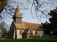
The village is in the district of Uttlesford and in the parliamentary constituency of Saffron Walden. There is a Parish Council.[2] According to the 2001 census it had a population of 526,[3] reducing to 508 at the 2011 Census.[1] The village lies on the road between Molehill Green and Thaxted. It has one public house, the Prince of Wales. In the 16th and 17th centuries, part of Broxted was known as Chawreth.[4]
According to the English ancestry section by J. Gardner Bartlett in the Shed Genealogy, 70 Thomas Shedd "was born in Chawreth (now Broxted), County Essex, in 1508, but when a young man settled in the adjoining rural parish of Debden in Uttlesford Hundred where he passed the rest of his life. This hilly parish covers about forty-five hundred acres, has a population of about eight hundred, and contains six manors, viz: Debden Hall, Deanes, [p. 13] Tendring, Weldbarnes, Molehall, and Amberden Hall, the latter located on rising ground in a grove two miles south-east of the church.
See also
References
- 1 2 "Civil Parish population 2011". Neighbourhood Statistics. Office for National Statistics. Retrieved 27 September 2015.
- ↑ "Uttlesford Information regarding Broxted". www.uttlesford.gov.uk. Archived from the original on September 27, 2007. Retrieved 2007-03-14.
- ↑ http://www.neighbourhood.statistics.gov.uk/dissemination/LeadTableView.do?a=3&b=794665&c=broxted&d=16&e=15&g=447288&i=1001x1003x1004&m=0&r=1&s=1311256858325&enc=1&dsFamilyId=779
- ↑ "Historical Gazetteer: Broxted". www.placenames.org.uk. The Historical Gazetteer of England's Place Names. Retrieved 18 February 2016.
External links
 Media related to Broxted at Wikimedia Commons
- Official Broxted Website, supported by Broxted Parish Council