Brusnengo
| Brusnengo | ||
|---|---|---|
| Comune | ||
| Comune di Brusnengo | ||
| ||
 Brusnengo Location of Brusnengo in Italy | ||
| Coordinates: 45°35′52″N 8°13′04″E / 45.59778°N 8.21778°ECoordinates: 45°35′52″N 8°13′04″E / 45.59778°N 8.21778°E | ||
| Country | Italy | |
| Region | Piedmont | |
| Province / Metropolitan city | Biella (BI) | |
| Frazioni | Forte, Caraceto | |
| Area | ||
| • Total | 10.4 km2 (4.0 sq mi) | |
| Elevation | 200 m (700 ft) | |
| Population (Dec. 2004) | ||
| • Total | 2,127 | |
| • Density | 200/km2 (530/sq mi) | |
| Demonym(s) | Brusnenghesi | |
| Time zone | CET (UTC+1) | |
| • Summer (DST) | CEST (UTC+2) | |
| Postal code | 13862 | |
| Dialing code | 015 | |
| Patron saint | St. Peter | |
| Saint day | June 29 | |
Brusnengo is a comune (municipality) in the Province of Biella in the Italian region Piedmont, located about 70 kilometres (43 mi) northeast of Turin and about 12 kilometres (7 mi) northeast of Biella. As of 31 December 2004, it had a population of 2,127 and an area of 10.4 square kilometres (4.0 sq mi).[1]
Brusnengo borders the following municipalities: Curino, Masserano, Roasio, Rovasenda.
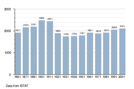
Demographic evolution
References
This article is issued from Wikipedia - version of the 1/31/2015. The text is available under the Creative Commons Attribution/Share Alike but additional terms may apply for the media files.