Buckingham Township, Wayne County, Pennsylvania
| Buckingham, Pennsylvania | |
|---|---|
| Second-class township | |
| Township of Buckingham | |
|
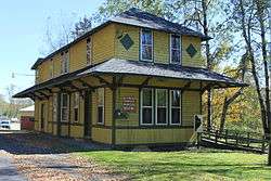
The former Starlight Station in Starlight, which is now the Buckingham Township Municipal Building. It is also a U.S. National Historic Place. | |
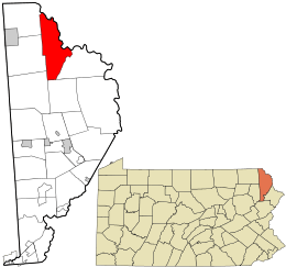 Location in Wayne County and the state of Pennsylvania. | |
| Country | United States |
| State | Pennsylvania |
| US Congressional District | PA-10 |
| State Senatorial District | 20 |
| State House of Representatives District | 111 |
| County | Wayne |
| School District |
Wayne Highlands Region I |
| Settled | c. 1789[1] |
| Incorporated |
March 21, 1798 (original township of Wayne County) |
| Founded by | Samuel Preston, Sr.[1] |
| Named for |
Buckingham Township (Bucks County)[2] |
| Government | |
| • Type | Board of Supervisors |
| • Board of Supervisors[3] |
Supervisors
|
| • US Representative | Tom Marino (R) |
| • State Senator | Lisa Baker (R) |
| • State Representative | Sandra Major (R) |
| Area | |
| • Total | 45.4 sq mi (118 km2) |
| • Land | 44.2 sq mi (114 km2) |
| • Water | 1.2 sq mi (3.1 km2) |
| Elevation | 1,043 ft (317.9 m) |
| Population (2010) | |
| • Total | 520 |
| • Density | 11.8/sq mi (4.41/km2) |
| Time zone | Eastern (EST) (UTC-5) |
| • Summer (DST) | Eastern Daylight (EDT) (UTC-4) |
| Area code(s) | 570 |
| GNIS feature ID | 1217248[4] |
| FIPS code | 42-127-09824[5] |
Buckingham is a second-class township in Wayne County, Pennsylvania. The township's population was 520 at the time of the 2010 United States Census.[6]
History
The Equinunk Historic District and Starlight Station, New York, Ontario, and Western Railway are listed on the National Register of Historic Places.[7]
Geography
According to the United States Census Bureau, the township has a total area of 45.4 square miles (118 km2), of which, 44.2 square miles (114 km2) of it is land and 1.2 square miles (3.1 km2) of it (2.64%) is water.
Communities
The following villages are located in Buckingham Township:
|
Demographics
As of the census of 2010, there were 520 people, 260 households, and 148 families residing in the township. The population density was 11.8 people per square mile (4.6/km²). There were 523 housing units at an average density of 11.8/sq mi (4.6/km²). The racial makeup of the township was 97.7% White, 0.2% African American, 0.6% Asian, 0.5% from other races, 1% from two or more races. Hispanic or Latino of any race were 2.5% of the population.
There were 260 households out of which 13.8% had children under the age of 18 living with them, 44.2% were married couples living together, 6.5% had a female householder with no husband present, and 43.1% were non-families. 35% of all households were made up of individuals and 18.1% had someone living alone who was 65 years of age or older. The average household size was 2.00 and the average family size was 2.53.
In the township the population was spread out with 13.1% under the age of 18, 60.9% from 18 to 64, and 26% who were 65 years of age or older. The median age was 53.3 years.
The median income for a household in the township was $40,268, and the median income for a family was $54,375. Males had a median income of $36,193 versus $30,000 for females. The per capita income for the township was $26,796. About 9.9% of families and 11.4% of the population were below the poverty line, including none of those under age 18 and 18.6% of those age 65 or over.
Images
-

Town Hall in Buckingham Township, PA (early spring 2012)
References
- 1 2 Goodrich, Phineas G. (1992) [1880]. History of Wayne County. Baltimore: Gateway Press, Inc. p. 217.
- ↑ "Buckingham Township". Wayne County Historical Society. Wayne County Historical Society. 2014. Retrieved 15 December 2014.
- ↑ "Municipal Index" (PDF). Wayne County Planning Commission/GIS. WordPress. 2011. Retrieved 22 November 2014.
- ↑ "Township of Buckingham". Geographic Names Information System. United States Geological Survey. 1 January 1990. Retrieved 22 November 2014.
- ↑ U.S. Census Bureau. Census 2000. "Census Demographic Profiles, Buckingham Township" (PDF). CenStats Databases. Retrieved 2009-01-31.
- ↑ "American FactFinder". United States Census Bureau. Archived from the original on 2013-09-11. Retrieved 2011-05-14.
- ↑ National Park Service (2010-07-09). "National Register Information System". National Register of Historic Places. National Park Service.
- 1 2 3 4 5 6 "BUCKINGHAM: SECOND CLASS TOWNSHIP MAP" (PDF). Pennsylvania Department of Transportation. Commonwealth of Pennsylvania. 4 August 2003. Retrieved 22 November 2014.
- ↑ "Autumn Leaves". Geographic Names Information System. United States Geological Survey. 2 August 1979. Retrieved 22 November 2014.
- ↑ "Balls Eddy". Geographic Names Information System. United States Geological Survey. 2 August 1979. Retrieved 19 December 2014.
- ↑ "Dillontown". Geographic Names Information System. United States Geological Survey. 2 August 1979. Retrieved 22 November 2014.
- ↑ "High Lake". Geographic Names Information System. United States Geological Survey. 2 August 1979. Retrieved 22 November 2014.
- ↑ Goodrich. p. 223.
- ↑ "Stockport". Geographic Names Information System. United States Geological Survey. 2 August 1979. Retrieved 22 November 1979. Check date values in:
|access-date=(help)
Municipalities and communities of Wayne County, Pennsylvania, United States | ||
|---|---|---|
| Boroughs |  | |
| Townships | ||
| CDPs | ||
| Unincorporated communities | ||