Buffalo Bill State Park
| Buffalo Bill State Park | |
| Wyoming State Park | |
 | |
| Named for: Buffalo Bill Cody | |
| Country | United States |
|---|---|
| State | Wyoming |
| County | Park |
| Elevation | 5,371 ft (1,637 m) [1] |
| Coordinates | 44°30′04″N 109°11′02″W / 44.50111°N 109.18389°WCoordinates: 44°30′04″N 109°11′02″W / 44.50111°N 109.18389°W [1] |
| Area | 11,290 acres (4,569 ha) |
| - Land | 3,140 acres (1,271 ha) [2] |
| - Water | 8,150 acres (3,298 ha) [2] |
| Established | 1957 |
| Management | Wyoming State Parks and Cultural Resources |
 Location in Wyoming
| |
| Website: Buffalo Bill State Park | |
Buffalo Bill State Park is state-operated, public recreation area surrounding the reservoir formed by the Buffalo Bill Dam, an impoundment of the Shoshone River, in Park County, Wyoming. The state park, reservoir and dam were named after William "Buffalo Bill" Cody, who founded the nearby town of Cody and who owned much of the land now occupied by the reservoir and park. The park's recreational opportunities include camping, hiking, boating, fishing and picnicking.[3]
History
Buffalo Bill Cody was one of the most colorful figures of the American Old West, mostly known for the shows he organized with cowboy themes. He once owned some of the land that is now part of the state park bearing his name. He sold his property to the United States government prior to the construction of Buffalo Bill Dam. Cody settled in the Shoshone Canyon area in the 1870s. He first came to the region as a guide for a survey expedition. Cody spent parts the next twenty years in the area serving as a hunting guide. Buffalo Bill worked to bring irrigation and agriculture development in Park County. He founded the nearby city of Cody in 1896.[4]
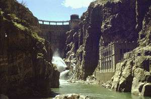
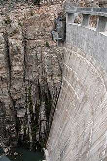
Construction on Buffalo Bill Dam, originally known as Shoshone Dam, began in 1905.[5] Upon completion, in 1910, the dam was the highest in the world standing at 325 feet (99 m).[4] The dam is a concrete concrete arch structure of constant radius.[6] It was part of the Shoshone Project, one of the first projects overseen by the Bureau of Reclamation.[7]
In addition to providing water for irrigation and downstream flood control, Buffalo Bill Dam provides hydropower for a power plant. The first and second units of the power plant were constructed in 1922. A third unit was built in 1931. Units one and two were decommissioned in 1980 and unit three was replaced in 1991.[8]
The park was established in 1957 and rebuilt in 1993 after an eight-year project to increase the height of the dam by 25 feet (7.6 m). The original park facilities were flooded when the dam was raised and the reservoir was deepened and widened. The project added 260,000 acre feet (320,000,000 m3) to the area of the lake. A visitors center at the dam was opened upon completion of the heightening of the dam. Further modifications to the dam included an expansion of the underground spillway and addition of gates to the spillway for flow control.[9]
Geology
Buffalo Bill State Park is in Shoshone Canyon along the Shoshone River in northwestern Wyoming. The mountainous area is part of the Absaroka Range of the Rocky Mountains.[4] The range is on the Montana-Wyoming border. They border the Beartooth Mountains to the north and the Wind River Range to the south. The mountains are named for the Absaroka Indians.[10] The name is derived from the Hidatsa name for the Crow people; it means "children of the large-beaked bird." [11]

Activities and amenities
Recreational activities at the park include fishing, boating, hiking, camping and picnicking. Picnicking facilities and park fencing were improved in 2007 by the Wyoming Conservation Corps.[12] The park is open May 1 through September 30 with limited access in winter.[3]
.jpg)
References
- 1 2 "Buffalo Bill Dam". Geographic Names Information System. United States Geological Survey.
- 1 2 "Buffalo Bill Reservoir Facilities". Bureau of Reclamation. May 27, 2015. Retrieved December 4, 2015.
- 1 2 "Buffalo Bill State Park". Wyoming State Parks, Historic Sites & Trails. State of Wyoming. Retrieved December 4, 2015.
- 1 2 3 "Buffalo Bill State Park Brochure" (PDF). Wyoming Department of State Parks and Cultural Resources. Retrieved December 4, 2015.
- ↑ "Buffalo Bill Dam History". Buffalo Bill Dam & Visitor Center. Retrieved December 4, 2015.
- ↑ "Buffalo Bill Dam". Bureau of Reclamation. April 30, 2013. Retrieved December 4, 2015.
- ↑ "Shoshone Project". Bureau of Reclamation. April 30, 2013. Retrieved December 4, 2015.
- ↑ "Shoshone Power Plant". Buffalo Bill Dam & Visitor Center. Retrieved December 4, 2015.
- ↑ "Buffalo Bill Dam Modification Project". Buffalo Bill Dam & Visitor Center. Retrieved December 4, 2015.
- ↑ Gannett, Henry (1905). The Origin of Certain Place Names in the United States. p. 22.
- ↑ Rich Aarstad, Ellie Arguimbau, Ellen Baumler, Charlene Porsild, Brian Shovers. Montana Place Names from Alzada to Zortman. Montana Historical Society Press.
- ↑ Staff and wire reports (July 5, 2007). "In brief". Casper Star-Tribune. Retrieved June 6, 2010.
External links
| Wikimedia Commons has media related to Buffalo Bill Dam. |
| Wikimedia Commons has media related to Buffalo Bill State Park. |
- Buffalo Bill State Park Wyoming State Parks, Historic Sites & Trails