Cahersiveen
| Cahersiveen Cathair Saidhbhín | |
|---|---|
|
Cahersiveen | |
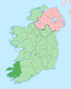
 Location in Ireland | |
| Coordinates: 51°56′53″N 10°13′26″W / 51.948°N 10.224°WCoordinates: 51°56′53″N 10°13′26″W / 51.948°N 10.224°W | |
| Country | Ireland |
| Province | Munster |
| County | County Kerry |
| Elevation | 79 m (259 ft) |
| Population (2013)[1] | |
| • Total | 1,401 |
| Irish Grid Reference | V469795 |
| Historical population | ||
|---|---|---|
| Year | Pop. | ±% |
| 1831 | 1,192 | — |
| 1841 | 1,492 | +25.2% |
| 1851 | 1,862 | +24.8% |
| 1861 | 1,802 | −3.2% |
| 1871 | 1,925 | +6.8% |
| 1881 | 2,003 | +4.1% |
| 1891 | 1,987 | −0.8% |
| 1901 | 2,013 | +1.3% |
| 1911 | 1,896 | −5.8% |
| 1926 | 1,773 | −6.5% |
| 1936 | 1,680 | −5.2% |
| 1946 | 1,779 | +5.9% |
| 1951 | 1,687 | −5.2% |
| 1956 | 1,801 | +6.8% |
| 1961 | 1,659 | −7.9% |
| 1966 | 1,649 | −0.6% |
| 1971 | 1,547 | −6.2% |
| 1981 | 1,428 | −7.7% |
| 1986 | 1,310 | −8.3% |
| 1991 | 1,213 | −7.4% |
| 1996 | 1,250 | +3.1% |
| 2002 | 1,272 | +1.8% |
| 2006 | 1,294 | +1.7% |
| 2013 | 1,401 | +8.3% |
| [2][3][4][5][6] | ||
Cahersiveen[7][8] (Irish: Cathair Saidhbhín, meaning "Little Sadhbh's stone ringfort")—alternate spellings Cahirsiveen, Cahirciveen or Caherciveen—is a town in the Region of Skellig Kerry, County Kerry, Ireland. It is located on the River Fertha and is the principal town of the Iveragh Peninsula. Cahersiveen is near Valentia Island and is connected to the Irish road network by the N70 road. It has a population of 1,294 (CSO 2006).
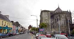
The Catholic church in the town is the only one in Ireland named after a lay person, Daniel O'Connell. It is situated on the slopes of Beentee.[8] It also contains a decommissioned Royal Irish Constabulary barracks, now a heritage centre, which according to legend, was built from the plans for a British barracks in India that got mixed up (a very common myth that occurs in many Irish garrison towns).
Cahersiveen was where the first shots of the Fenian Rising were fired in 1867.
Schools
The towns primary school Scoil Saidbhín was opened in September 2015. This school is an amalgamation of Scoil Mhuire, the boys primary school and St.Joseph's convent, the girls' primary school. There are 4 primary schools in total in the parish of Cahersiveen, including schools on the outskirts of the town: Aghatubrid National school, Coars National School, and Foilmore National School. The Aghatubrid school was established in 1964 and has approximately 88 students.
Colaiste Na Sceilge is the co-ed secondary school located in Cahersiveen. Over 530 pupils attend Coláiste Na Sceilge. Pupils from all around Iveragh attend the secondary school. For students interested in speaking their native language there is An t-Aonad Lán-Ghaeilge. It is an all Irish-speaking class for 1st to 3rd year students, where students do all their learning through Irish. In 2012/2013 there were 26 students who enrolled into An t-Aonad Lán-Ghaeilge. The school's website is http://colaistenasceilge.ie/ You can find a list of the primary schools and their contact details on the Coláiste Na Sceilge website.
People
- Thomas O'Brien Butler, composer of the opera Muirgheis
- Cornelius Casey, American soccer player
- Sigerson Clifford, writer and poet
- Maurice Fitzgerald, footballer
- Fionán Lynch, TD
- John Robert Monsell, children's book illustrator and author
- John Murphy, founder of a civil engineering contractor firm
- Daniel O'Connell, 19th-century Irish politician and campaigner for Catholic Emancipation and Repeal of the 1801 Act of Union
- John O'Donoghue Former TD
- Hugh O'Flaherty, Monseigneur known as the Vatican's Scarlet Pimpernel
- Jack O'Shea, footballer
- John O'Shea, CEO of the GOAL humanitarian agency
- Patrick O'Sullivan, railway author and historian.
- Bernard O'Connor, footballer
- Ada English, psychiatrist (of the first generation of women physicians in Ireland) and revolutionary activist and politician
Gallery
-

Gate on New Street
-

Cahersiveen Barracks
-
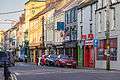
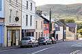
Cahersiveen Main Street
-
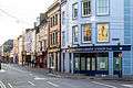
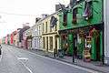
Caherciveen, Main Street/O'Connell Street
-
Cahersiveen, O'Connell Street
-
Cahersiveen West Main Street
See also
References
| Wikivoyage has a travel guide for Caherciveen. |
| Wikimedia Commons has media related to Cahirciveen. |
- ↑ "Census 2006 – Volume 1 – Population Classified by Area" (PDF). Central Statistics Office Census 2006 Reports. Central Statistics Office Ireland. April 2007. Archived from the original (PDF) on 2011-06-07. Retrieved 2011-06-14.
- ↑ Census for post 1821 figures.
- ↑ http://www.histpop.org
- ↑ "Archived copy". Archived from the original on 2012-02-17. Retrieved 2014-02-09.
- ↑ Lee, JJ (1981). "On the accuracy of the Pre-famine Irish censuses". In Goldstrom, J. M.; Clarkson, L. A. Irish Population, Economy, and Society: Essays in Honour of the Late K. H. Connell. Oxford, England: Clarendon Press.
- ↑ Mokyr, Joel; O Grada, Cormac (November 1984). "New Developments in Irish Population History, 1700-1850". The Economic History Review. 37 (4): 473–488. doi:10.1111/j.1468-0289.1984.tb00344.x.
- ↑ Placenames Database of Ireland
- 1 2 Ordnance Survey Ireland - Online map viewer