Calapooya Creek
| Calapooya Creek | |
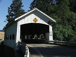 Rochester Covered Bridge over Calapooya Creek | |
| Name origin: For a division of the Kalapuya people living between the Willamette and Umpqua rivers [1] | |
| Country | United States |
|---|---|
| State | Oregon |
| County | Douglas |
| Source | Confluence of the creek's north and south forks |
| - location | South side of Calapooya Divide |
| - coordinates | 43°28′51″N 123°01′56″W / 43.48083°N 123.03222°W |
| Mouth | Umpqua River |
| - location | Umpqua |
| - coordinates | 43°21′57″N 123°27′58″W / 43.36583°N 123.46611°WCoordinates: 43°21′57″N 123°27′58″W / 43.36583°N 123.46611°W [2] |
| Length | 37 mi (60 km) [3] |
| Basin | 246 sq mi (637 km2) [4] |
 Location of the mouth of Calapooya Creek in Oregon
| |
Calapooya Creek is a tributary, about 37 miles (60 km) long, of the Umpqua River in Douglas County in the U.S. state of Oregon. Formed by its north and south forks, the creek drains a mountainous region south of the Calapooya Divide and east of Oakland and Sutherlin.[3]
From its source, the creek flows generally southwest through or near Nonpareil and Oakland. Near Oakland it passes under Oregon Route 99 and Interstate 5 and further downstream Oregon Route 138 before entering the river at the rural community of Umpqua.[3]
Bridge
Rochester Covered Bridge carries Rochester Road over Calapooya Creek about 3 miles (5 km) west of Sutherlin.[5] Built in 1933, its unusual design features side windows with curved tops.[6]
Tributaries
Named tributaries from source to mouth are the North Fork Calapooya Creek and South Fork Calapooya Creek. Then come White, Coon, Timothy, Buzzard Roost, Cooper, and Filler creeks. Below these come Jeffers, Hinkle, Gilbreath, Gassy, Cantell, Pelland, Long Valley, and Banks creeks. Further downstream are Foster, Oldham, Pollock, Cabin, Cook, Dodge Canyon, Coon, and Burke creeks.[3]
See also
References
- ↑ McArthur, Lewis A.; McArthur, Lewis L. (2003) [1928]. Oregon Geographic Names (7th ed.). Portland, Oregon: Oregon Historical Society Press. pp. 137–38. ISBN 0-87595-277-1.
- ↑ "Calapooya Creek". Geographic Names Information System. United States Geological Survey. November 28, 1980. Retrieved March 21, 2016.
- 1 2 3 4 "United States Topographic Map". United States Geological Survey. Retrieved March 21, 2016 – via Acme Mapper. The map includes mile markers along Calapooya Creek from mouth to source.
- ↑ "Oregon Explorer: Calapooya Creek Watershed". Oregon State University. 2014. Retrieved March 21, 2016.
- ↑ "Calapooya Creek (Rochester) Covered Bridge" (PDF). Oregon Department of Transportation. Retrieved March 20, 2016.
- ↑ Smith, Dwight A.; Norman, James B.; Dykman, Pieter T. (1989) [1986]. Historic Highway Bridges of Oregon (2nd ed.). Portland: Oregon Historical Society Press. p. 81. ISBN 0-87595-205-4.