Calceby
| Calceby | |
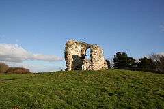 Ruins of St Andrew's Church, Calceby |
|
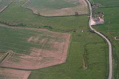 Calceby brook and spring. The source of the Great Eau |
|
 Calceby |
|
| OS grid reference | TF389755 |
|---|---|
| – London | 120 mi (190 km) S |
| District | East Lindsey |
| Shire county | Lincolnshire |
| Region | East Midlands |
| Country | England |
| Sovereign state | United Kingdom |
| Post town | Alford |
| Postcode district | LN13 |
| Police | Lincolnshire |
| Fire | Lincolnshire |
| Ambulance | East Midlands |
| EU Parliament | East Midlands |
|
|
Coordinates: 53°15′32″N 0°04′55″E / 53.259025°N 0.0819°E
Calceby is a small village in the East Lindsey district of Lincolnshire, England. It is situated approximately 4 miles (6 km) west from the market town of Alford.The population is included in the civil parish of South Thoresby.
Once much larger, Calceby is recorded in the Domesday Book as "Calesbi". Lord of the Manor in 1086 was Earl Hugh of Chester.[1] The church of St Andrew is in ruins, the last service to take place there being in 1692.[2]
Calceby Beck & Spring are the source of the Great Eau, and are part of the local network of Chalk Streams.[3][4]
Calceby Marsh has been designated a Site of Special Scientific Interest (SSSI) as "an outstanding example of base-rich marsh". The site consists of three areas of marshland, each differing slightly in species composition and surrounded by grassland of value to breeding snipe and lapwing.[5]
References
- ↑ "Domesday Book:Calceby". Domesday Maps: University of Hull. Retrieved 5 May 2011.
- ↑ "Lincolnshire Wolds:Calceby". Lincolnshire Wolds. Retrieved 5 May 2011.
- ↑ "Calceby Beck, South Thoresby" (PDF). Lincolnshire Chalk Streams Project. Retrieved 18 May 2013.
- ↑ "The Lincolnshire Chalk Streams Project". Lincolnshire Wolds Countryside Service. Retrieved 18 May 2013.
- ↑ "Calceby Marsh" (PDF). English Nature Org. Retrieved 5 May 2011.
External links
 Media related to Calceby at Wikimedia Commons
England Portal | |
| Unitary authorities | |
| Boroughs or districts | |
| Major settlements |
|
| Topics | |