Calf of Eday
| Norse name | Kalfr |
|---|---|
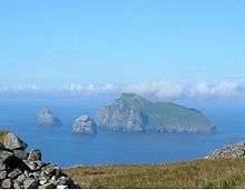
 Grey Head, the northern tip of the Calf. Sea caves, and the beginning of an arch can be seen in the cliff. | |
| Location | |
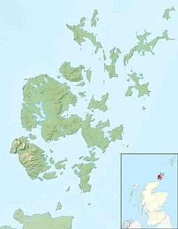 Calf of Eday Calf of Eday shown within the Orkney Islands | |
| OS grid reference | HY580393 |
| Physical geography | |
| Island group | Orkney |
| Area | 243 hectares (0.94 sq mi) |
| Area rank | 98 [1] |
| Highest elevation | The Graand 54 metres (177 ft) |
| Administration | |
| Sovereign state | United Kingdom |
| Country | Scotland |
| Council area | Orkney Islands |
| Demographics | |
| Population | 0[2] |
| References | [6][7] |
The Calf of Eday (Old Norse: Kalfr[6]) is an uninhabited island in Orkney, Scotland, lying north east of Eday. It is known for its wildlife and its prehistoric ruins.
History
There is a Neolithic chambered cairn in the southwest overlooking Calf Sound, which separates the island from Eday. Rectangular in shape, the cairn was excavated in 1936–37 and contains a small chamber with two compartments and a larger one with four stalls that has a separate entrance and was probably added at a later date.[8] Two similar structures have been identified nearby along with various other ancient ruins.[5]
From the 17th to the 19th centuries, the Calf of Eday was home to a salt works,[9] the remains of which can still be seen to the north of cairns.[5]
The pirate John Gow and his men successfully raided the Hall of Clestrain on 10 February 1725, but when they attempted to attack Carrick House on Eday, they ran aground on the Calf of Eday, where they were captured.[10][11]
Etymology

The Norse gave animal names to some islands, especially to small islands alongside a larger one, other examples being the Calf of Man and the Horse of Copinsay. The islands name in Norse times was thus Kalfr.[6] "Eday" is a name derived from the Old Norse eið and means "isthmus island".[12][13]
In the 17th century Eday was also known as "Heth Øy" and the Calf's name is recorded by Blaeu as "Calf of Heth Øy".[14]
Wildlife
The dominant vegetation on the island is dry dwarf-shrub heath dominated by Heather (Calluna vulgaris), with smaller areas of wet heath, semi-improved grassland and coastal grassland. The Calf of Eday supports 32 species of breeding birds and is designated as a Special Protection Area (SPA) for its importance as a nesting area. Gulls and Cormorant (Phalacrocorax carbo) nest in the dry heath and grassland areas, whilst Fulmar (Fulmarus glacialis), Kittiwake (Rissa tridactyla) and auks nest on the cliffs.[15]
See also
Notes
- ↑ Area and population ranks: there are c. 300 islands over 20 ha in extent and 93 permanently inhabited islands were listed in the 2011 census.
- ↑ National Records of Scotland (15 August 2013) (pdf) Statistical Bulletin: 2011 Census: First Results on Population and Household Estimates for Scotland - Release 1C (Part Two). "Appendix 2: Population and households on Scotland’s inhabited islands". Retrieved 17 August 2013.
- ↑ Haswell-Smith (2004) pp. 390-91
- ↑ Orkney Placenames Orkneyjar.
- 1 2 3 Ordnance Survey: Landranger map sheet 5 Orkney (Northern Isles) (Map). Ordnance Survey. 2008. ISBN 9780319228111.
- 1 2 3 Anderson (1873) p. 176
- ↑ Pedersen, Roy (January 1992) Orkneyjar ok Katanes (map, Inverness, Nevis Print)
- ↑ Noble (2006) pp. 116–17
- ↑ Stewart, Walter (mid-1640s) "New Choreographic Description of the Orkneys" in Irvine (2006) p. 24
- ↑ "Overview of John Gow". Gazetteer for Scotland. Retrieved 2007-04-15.
- ↑ "John Gow - The Orkney Pirate". Orkneyjar, the heritage of the Orkney Islands. Retrieved 2007-04-15.
- ↑ Haswell-Smith p. 386
- ↑ Waugh (2010) p. 550
- ↑ Blaeu, Johan (mid-1654) "Orcadum and Shetlandiæ" in Irvine (2006) p. 33
- ↑ "Calf of Eday SPA Description". Joint Nature Conservation Committee. Retrieved 2007-11-11.
References
- Anderson, Joseph (ed.) (1873) The Orkneyinga Saga. Translated by Jón A. Hjaltalin & Gilbert Goudie. Edinburgh. Edmonston and Douglas. The Internet Archive. Retrieved 26 August 2013.
- Haswell-Smith, Hamish (2004). The Scottish Islands. Edinburgh: Canongate. ISBN 978-1-84195-454-7.
- Irvine, James M. (ed.) (2006) The Orkneys and Schetland in Blaeu's Atlas Novus of 1654. Ashtead. James M. Irvine. ISBN 0-9544571-2-9
- Noble, Gordon (2006) Neolithic Scotland: Timber, Stone, Earth and Fire. Edinburgh University Press. ISBN 0-7486-2338-8
- Waugh, Doreen, "On eið-names in Orkney and other North Atlantic islands" in Sheehan, John and Ó Corráin, Donnchadh (2010) The Viking Age: Ireland and the West. Proceedings of the Fifteenth Viking Congress. Dublin. Four Courts Press. ISBN 978-1-84682-101-1
|  | ||||||||||||||||||||||||||||
|
| |||||||||||||||||||||||||||||
| |||||||||||||||||||||||||||||
| |||||||||||||||||||||||||||||
| |||||||||||||||||||||||||||||
| |||||||||||||||||||||||||||||
| |||||||||||||||||||||||||||||
| |||||||||||||||||||||||||||||
Coordinates: 59°14′N 2°44′W / 59.233°N 2.733°W