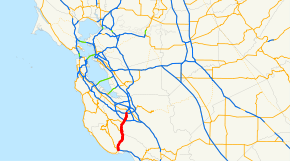
California State Route 17
| ||||
|---|---|---|---|---|
 | ||||
| Route information | ||||
| Defined by Streets and Highways Code § 317 | ||||
| Maintained by Caltrans | ||||
| Length: | 26.49 mi[1] (42.63 km) | |||
| Existed: | 1930s[2] – present | |||
| Major junctions | ||||
| South end: |
| |||
|
| ||||
| North end: |
| |||
| Highway system | ||||
| ||||

State Route 17 (SR 17) is a freeway and expressway that runs between San Jose and Santa Cruz in the U.S. State of California. SR 17 carries substantial commuter and vacation traffic between Santa Cruz and the rest of the San Francisco Bay Area.
Route description
SR 17 is part of the California Freeway and Expressway System[3] and is eligible for the State Scenic Highway System.[4] However, it has not been designated as a scenic highway by Caltrans.[5]
From its southern terminus with SR 1 in Santa Cruz, Route 17 begins as a four-lane freeway. From there, it proceeds through Scotts Valley. At the north end of Scotts Valley, it becomes a four-lane divided highway, with access at various points without interchanges, and begins a winding ascent of the Santa Cruz Mountains. The road crosses the Santa Clara/Santa Cruz county line through the Patchen Pass, commonly referred to as "The Summit", at an elevation of 1,800 feet (549 m), where there is an interchange with SR 35. Just north of the summit, a winding descent of the mountains begins, again with access at various points, mostly without grade separations, as far as Los Gatos. At Los Gatos, Route 17 becomes a freeway again. It expands to six lanes after an interchange with SR 85. This interchange has three levels; it is unusual in that the top level (CA 17) is at-grade, with the other levels below-grade. The number of lanes later expands to eight shortly before reaching its northern terminus at Interstate 280, where it continues as Interstate 880.
Safety

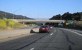
SR 17's combination of narrow shoulders, dense traffic, sharp turns, blind curves, wandering fauna such as deer and mountain lions, and sudden changes in traffic speeds have led to driving conditions that result in a number of accidents and fatalities, leading to the reputation of SR 17 as one of the most dangerous highways in the state. In the winter months, because SR 17 crosses a high precipitation area in the Santa Cruz Mountains, the roadway can become slippery from rain, snow or ice, especially at the summit.
Some sections of SR 17 are so dangerous that they have been nicknamed. The first long sweeping turn North of Summit Road with its sharp angle and steep entering downhill slope is called "The Valley Surprise" for the fact that so many strike the median shortly after having entered the Santa Clara Valley. The most infamous is called "Big Moody Curve". This curve is named after Big Moody Creek below, slightly greater than a 180 degree turn, and bracketed by additional 90 degree turns. The inside surfaces of the median barriers in both of these turns are normally chipped up and black with tire rubber.
Efforts to improve safety have included adding electronic speed monitoring signs and warnings lights on curves, removing trees to improve visibility around blind curves, and increased patrol and enforcement of traffic laws. The portion between Los Gatos and Scotts Valley has been designated the Highway 17 Safety Corridor by Caltrans and the California Highway Patrol.
Gillian Cichowski Memorial Overcrossing Bridge, over SR 17 near Los Gatos at Lexington Reservoir, was named by California Senate Concurrent Resolution 32, Chapt. 70 in 1994. Gillian Cichowski was killed in an accident at this location in 1992. This is one of the few highway constructions in California named for a woman. The overpass was in response to a campaign by friends of Gillian Cichowski to make the intersection (with Bear Creek Road) safer. The overpass was open to northbound traffic July 18, 1996 and opened to southbound traffic August 29, 1996. Margaret Green of Sunnyvale, California died in a similar accident near the same location during overpass construction.
SR 17 in Santa Cruz County is named after California Highway Patrol Lieutenant Michael Walker. Walker was setting flares to direct traffic around an auto accident on New Year's Eve 2005 when he was struck and killed.[6] Partly in response to this accident near the Glenwood Road intersection, Caltrans began work in 2008 to widen the shoulder to eight feet.[7]
History
The earliest connection between Santa Cruz and San Jose was an old Native American foot trail. The first road that could be navigated by a wagon was a dirt toll road built by Charlie McKiernan, known as "Mountain Charlie" by locals, some time around 1853. Portions of this road still exist as Mountain Charlie Road, to the west of Highway 17 and south of Summit Road. Several other stage lines were built as competitors, such as the San Jose Turnpike (1863), which follows the approximate route of present-day Soquel San Jose Road. After realignment to increase the road width; many sections of the original stage route were cut off. These sections became side streets named with variations containing Old Turnpike. Some of these now dead end streets have retained the look of narrow stage coach roads.
SR 17 was opened in 1940, replacing several other modes of transportation, including the old Glenwood Highway from 1919 (which still exists in Glenwood), and the railroad which went all the way from Santa Cruz to San Francisco and Oakland. The railroad stopped operating in 1940 and the tunnels that it passed through were sealed soon after. Nearly all the tunnel entrances still exist, but are unusable as the tunnels themselves are collapsed. The rise in the use of automobiles made the railroads unprofitable. The city of Glenwood, founded by Charles C. Martin in 1851, gained notoriety for hot springs in the area. The Glenwood Highway, which passed through town, was deserted when the "New 17" was built, and the town became a ghost of its former self. The town has but one resident left, Mrs. Ed C. Koch, who is the great-granddaughter of the founder.
Parts of the original SR 17 lie underwater in Lexington Reservoir. When the reservoir was built, the highway was rerouted to higher ground, and the two towns along its path (Alma and Lexington) were abandoned. When the reservoir levels are extremely low, the old highway pavement is visible as well as some stone and concrete foundations of buildings.
Until the mid-1980s, SR 17 extended from its current southern terminus at State Route 1 in Santa Cruz through Oakland and across the Richmond-San Rafael Bridge to San Rafael. The roadway still exists (apart from the mile-long Cypress section in Oakland, destroyed in the 1989 Loma Prieta earthquake) but parts have been redesignated. The section between Interstate 80 and US 101 in San Rafael was renumbered as an extension of Interstate 580. Prior to the redesignation, this part of SR 17 followed Richmond streets, including an expressway called Hoffman Boulevard, to the bridge; a freeway built to Interstate standards was completed in 1990 after the corridor became 580's northwestern leg. Additionally, SR 17 between Interstate 280 in San Jose and the freeway's new northern terminus in Oakland was re-designated as Interstate 880 later that year.
Before the freeway was built in Milpitas, Fremont, Hayward and Oakland, SR 17 followed what is now Old Oakland Road (San Jose), Main Street (Milpitas) and Warm Springs Boulevard (southern Fremont); from the Irvington section of Fremont, the route proceeded along what is now Fremont Boulevard, which becomes Alvarado Boulevard in Union City. From there, the route proceeded along Hesperian Boulevard in Hayward and Washington Avenue in San Leandro, joining with East 14th Street as it proceeded into Oakland. From Oakland, SR 17 would follow US 40 along San Pablo Avenue up to its split in Albany. SR 17 then followed what is now Interstate 580 over the San Rafael Bridge (formerly a ferry crossing), terminating at US 101 in San Rafael.
Major intersections
Except where prefixed with a letter, postmiles were measured on the road as it was in 1964, based on the alignment that existed at the time, and do not necessarily reflect current mileage. R reflects a realignment in the route since then, M indicates a second realignment, L refers an overlap due to a correction or change, and T indicates postmiles classified as temporary (for a full list of prefixes, see the list of postmile definitions).[8] Segments that remain unconstructed or have been relinquished to local control may be omitted. The numbers reset at county lines; the start and end postmiles in each county are given in the county column.
| County | Location | Postmile [8][9][10] | Exit [11] | Destinations | Notes |
|---|---|---|---|---|---|
| Santa Cruz SCR 0.00-12.55 | Santa Cruz | 0.00 | 1 | Southbound exit and northbound entrance; signed as exits 1A (north) and 1B (south); south end of SR 17; SR 1 north exit 441B, south exit 441 | |
| | 0.74 | 1C | Pasatiempo Drive | Signed as exit 1 northbound | |
| | 2.18 | El Rancho Drive, La Madrona Drive | |||
| Scotts Valley | 3.44 | 3 | Mount Hermon Road | ||
| 5.45 | 5 | Granite Creek Road, Scotts Valley Drive (SR 17 Bus. south) | |||
| | | 6 | Santa's Village Road | Northbound exit and entrance | |
| | | North end of freeway | |||
| Santa Clara SCL 0.00-13.95 | | 0.11 | Summit Road (SR 35) | Interchange | |
| | 1.25 | Redwood Estates | Interchange | ||
| | 4.06 | Bear Creek Road | Interchange | ||
| | | South end of freeway | |||
| Los Gatos | 6.16 | 19 | Santa Cruz Avenue | Northbound left exit and southbound entrance | |
| 7.07 | 20A | East Los Gatos (CR G10) | |||
| 7.07 | 20B | ||||
| 8.89 | 21 | Lark Avenue | Northbound entrance cannot access SR 85 | ||
| 9.35 | 22 | SR 85 north exit 11, south exit 11A | |||
| Campbell | 10.50 | 23 | Camden Avenue, San Tomas Expressway (CR G4) | ||
| 12.34 | 25 | Hamilton Avenue | |||
| San Jose | 13.95 | 26 | Northbound exit and southbound entrance; signed as exits 26A (south) and 26B (north, Stevens Creek Boulevard); north end of SR 17; I-280 exit 5B | ||
| 13.95 | Continuation beyond I-280 | ||||
| 1.000 mi = 1.609 km; 1.000 km = 0.621 mi | |||||
See also
-
 California Roads portal
Notes
- ↑ January 1, 2006 California Log of Bridges on State Highways
- ↑ California Highways: State Route 17
- ↑ CA Codes (shc:250-257)
- ↑ CA Codes (shc:260-284
- ↑ California Department of Transportation, Officially Designated Scenic Highways, accessed 2010-03-20
- ↑ Lt. Michael Walker Killed New Year’s Eve While Aiding Motorist , accessed August 26, 2008
- ↑ Caltrans Public Notice (PDF), access August 26, 2008
- 1 2 California Department of Transportation. "State Truck Route List". Sacramento: California Department of Transportation. Archived from the original (XLS file) on June 30, 2015. Retrieved June 30, 2015.
- ↑ California Department of Transportation, Log of Bridges on State Highways, July 2007
- ↑ California Department of Transportation, All Traffic Volumes on CSHS, 2005 and 2006
- ↑ California Department of Transportation, California Numbered Exit Uniform System, State Route 17 Freeway Interchanges, Retrieved on 2009-02-05.
References
- Richard Beal: Highway 17: The Road to Santa Cruz. Aptos, California: Pacific Group, 1990. ISBN 0-9629974-0-4
External links
| Wikimedia Commons has media related to California State Route 17. |