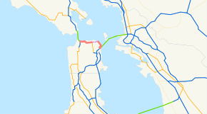
California State Route 480
| ||||
|---|---|---|---|---|
| Embarcadero Freeway; Golden Gate Freeway (unbuilt Western section) | ||||
 | ||||
| Route information | ||||
| Maintained by Caltrans | ||||
| Existed: | 1968 – 1991[1] | |||
| Major junctions | ||||
| West end: |
| |||
| East end: |
| |||
| Highway system | ||||
| ||||

State Route 480 was a state highway in San Francisco, California, United States, consisting of the elevated double-decker Embarcadero Freeway (also known as the Embarcadero Skyway), the partly elevated Doyle Drive approach to the Golden Gate Bridge and the proposed and unbuilt section in between. The unbuilt section from Doyle Drive to Van Ness Avenue was to have been called the Golden Gate Freeway and the Embarcadero Freeway as originally planned would have extended from Van Ness along the north side of Bay Street and then along the Embarcadero to the San Francisco-Oakland Bay Bridge.
The Embarcadero Freeway, which had only been constructed from Broadway along the Embarcadero to the Bay Bridge, was demolished after the 1989 Loma Prieta earthquake, and Doyle Drive is now part of U.S. Route 101. SR 480 was Interstate 480, an auxiliary route of the Interstate Highway System, from 1955 to 1965.[1][2] The entire route was deleted in 1991.[1]
History
| |
|---|---|
| Location: | San Francisco, California |
| Existed: | 1955–1968 |
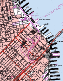
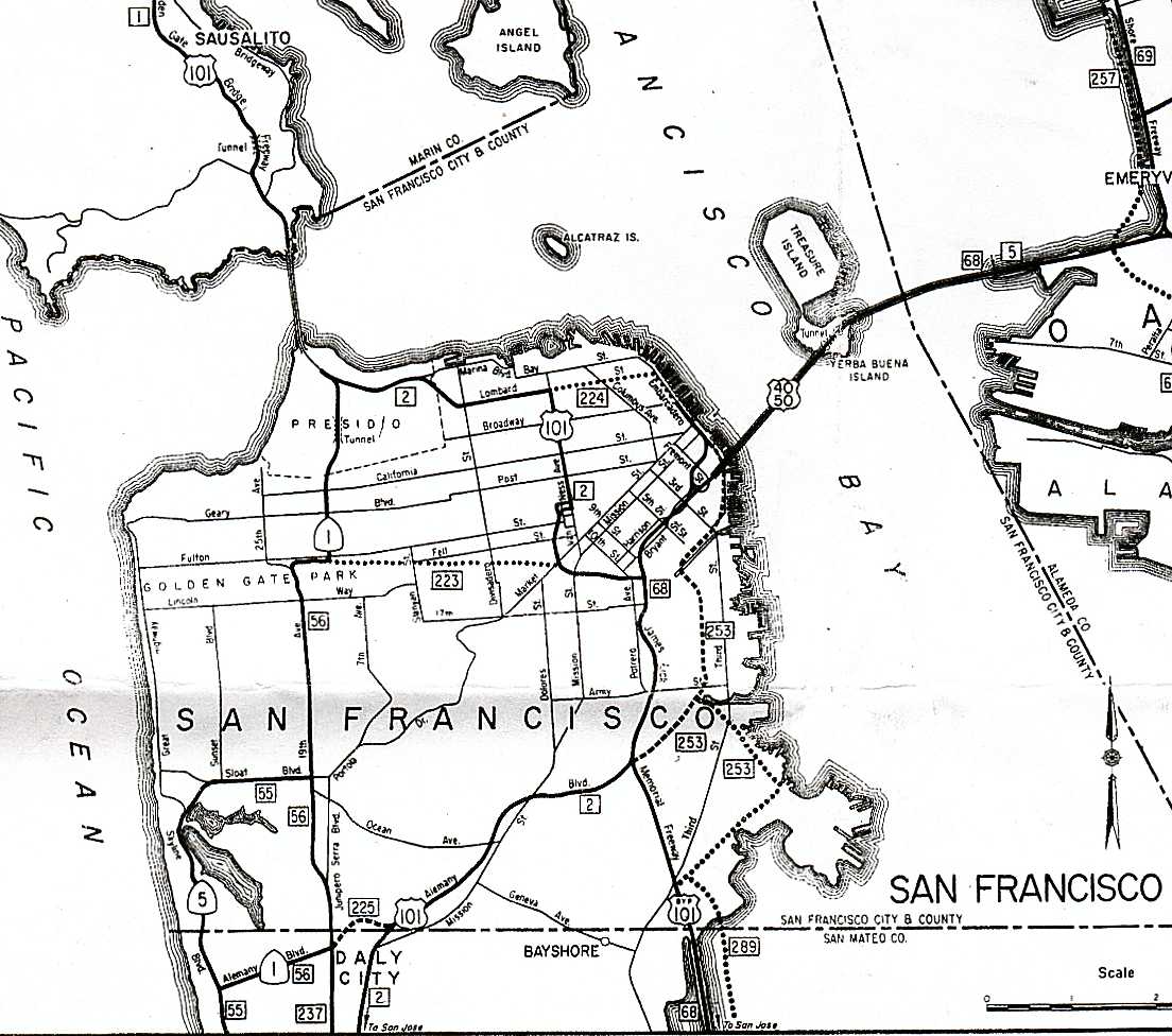
Legislative Route 224 was defined in 1947 to connect U.S. Route 101 (pre-1964 Legislative Route 2) at the intersection of Lombard Street and Van Ness Avenue with U.S. Route 40 and U.S. Route 50 (pre-1964 Legislative Route 68) at the west end of the San Francisco–Oakland Bay Bridge (near the Transbay Terminal).[3] Its alignment was roughly along Lombard Street and the Embarcadero.[4]
Legislative Route 224, as well as Route 2 (US 101) from Route 224 west to the junction with State Route 1 near the Golden Gate Bridge, was added to the Interstate Highway System on September 15, 1955. This included the 1936 Doyle Drive, an early freeway built to access the Golden Gate Bridge.[5] After some discussion, the name Interstate 480 was assigned on November 10, 1958. (Interstate 280, as originally planned, ran south from the west end of I-480 along SR 1, through the MacArthur Tunnel and Golden Gate Park, to join its present alignment in Daly City.)[6]
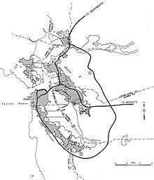
In the original 1955 plan, it was planned to extend the Central Freeway as a double decked structure between Van Ness Ave. and Polk Street north to Clay Street, then as a single deck depressed freeway north to Broadway, where it would have tunneled under Russian Hill to connect with Interstate 480.
The first section of the Embarcadero Freeway, from the Bay Bridge approach (Interstate 80) north to Broadway, opened in 1959.[7] As a consequence of the freeway revolt, the San Francisco Board of Supervisors passed Resolution 45-59 in January 1959, opposing certain freeways, including the remainder of I-480.[8] The freeway revolt continued after a new freeway plan was proposed in 1964, with a major protest on May 17, 1964—200,000 people rallied in Golden Gate Park against any more new freeways. Poet Kenneth Rexroth spoke at the rally (among others), and folk singer Malvina Reynolds sang (she was most famous for her song "Little Boxes", attacking urban sprawl, which she sang at the anti-freeway rally).[9]
The proposed unbuilt section as replanned in 1964 would have extended not from the Lombard St. exit of Doyle Drive along Lombard St. as originally planned in 1955, but from the Marina Blvd. exit of Doyle Drive, through the Marina Green and then along the north side of Fort Mason, then along the north side of Bay Street to the Embarcadero and south along the Embarcadero to connect with the former Embarcadero Freeway. The section between the Golden Gate Bridge (including an upgraded Doyle Drive) and Van Ness Ave. would have been named the Golden Gate Freeway; the rest of the freeway to the east of Van Ness Ave. would have been the extended originally planned full length of the Embarcadero Freeway, originally planned to extend from Van Ness Ave. to the San Francisco-Oakland Bay Bridge–going east first down the north side of Bay Street, then going southeast curving around the base of Telegraph Hill and meeting at Broadway the former end of the actually constructed section of the Embarcadero Freeway.[10][11]
In the 1964 renumbering, Route 480 was designated for the full route of I-480, including the US 101 concurrency. The route was deleted from the Interstate Highway System in January 1968, with Interstate 280 being rerouted north of Daly City at the same time. The short piece of former I-480 from the junction with new I-280 (previously State Route 87) south to the Bay Bridge approach became part of I-280 (to allow I-280 to meet I-80), now named the Southern Embarcadero Freeway.[6] These changes were made to the state highway system in 1968; Route 480 was truncated only slightly, with the 5.47 miles[12] (8.80 km) from I-280 to SR 1 remaining, though downgraded to State Route 480; this extension of I-280 south (the Junipero Serra Freeway) is considered the southern terminus of Junipero Serra Boulevard.[8]
Demise
In the 1980s, opposition to the Embarcadero Freeway resurfaced in proposals to tear it down. On November 5, 1985, the San Francisco Board of Supervisors voted to tear down the Embarcadero Freeway.[7] The proposal was put to the voters in 1987 and soundly defeated, opposed in particular by influential Chinatown community organizer Rose Pak, who feared that Chinatown would suffer catastrophic consequences if it would lose this fast crosstown connection.[13][14] The October 17, 1989, earthquake significantly damaged the structure, causing it to be closed to traffic. Caltrans planned to retrofit and retain the double-decker freeway. Various groups in and outside the City supported the Caltrans plan, but there was a significant opinion within the City in favor of removing the freeway structure. Then-Mayor Art Agnos proposed demolishing the freeway in favor of a boulevard with an underpass at the Ferry Building to allow for a large plaza.[15]
Opposition to demolishing the freeway mounted again, with over 20,000 signatures gathered to again create a ballot measure.[15] Prior to the earthquake, the Embarcadero Freeway carried approximately 70,000 vehicles daily in the vicinity of the Ferry Building. Another 40,000 vehicles per day used associated ramps at Main and Beale streets. The strongest opposition came from Chinatown and other neighborhoods north of downtown.[16] Merchants in Chinatown had suffered a dramatic decline in business in the months immediately following the earthquake and feared that if the freeway was not reopened they would not recover.[17]
Agnos continued to negotiate with federal and state officials to win enough funding to make the demolition practical, and the opposition relented. Agnos argued that the city would squander "the opportunity of a lifetime" if it allowed the freeway to remain.[16] After months of debate, the Board of Supervisors narrowly voted in favor of demolition by a 6-5 margin.[15] Demolition began on February 27, 1991.[18] That year, Agnos was defeated for re-election as Chinatown switched its support away from him.
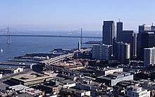
Meanwhile, the state legislature deleted SR 480 from the state's Streets and Highway Code.[1] The northwest section was transferred to US Route 101.[8] The only piece of the Embarcadero Freeway to remain was the beginning of the ramp from the Bay Bridge to Fremont Street, including a short ramp stub that formerly carried traffic to the freeway (Interstate 280 after 1968). This part was rebuilt as part of the Bay Bridge retrofit project. (I-280 was never finished to that interchange, though its legislative definition still takes it there.[19]) In 2003, Caltrans began work on a retrofitting project to replace the western approach to the Bay Bridge. This retrofitting was part of a larger, $6-billion project to upgrade the aging Bay Bridge to modern earthquake standards, which included replacing the entire eastern span. In late 2005, Caltrans began the demolition of the original western approach after traffic was routed onto a temporary bypass structure. As a result of this retrofitting project, all old parts of the approach have been replaced, removing the final remains of the Embarcadero Freeway. The western approach to the Bay Bridge was completed in 2009; the entire project was completed in 2013.[20]
Legacy
.jpg)
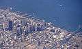
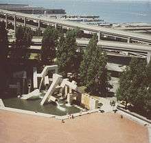
Along the waterfront, the former freeway was replaced with a wide, palm-lined boulevard with Muni Light Rail tracks in the median.[21] Muni's N Judah, T Third Street, and F Market & Wharves lines were extended to run along the Embarcadero. Sue Bierman Park replaced offramps just north of the Embarcadero Center,[22] and Ferry Plaza was constructed in front of the San Francisco Ferry Building, which itself was remodeled into an upscale gourmet marketplace in 2003. Other new parks include Pier 14 Public Pier,[23] Rincon Park near Folsom Street,[24] and the Brannan Street Wharf.[25] A former onramp at Broadway and Sansome streets has been redeveloped as 75 new affordable housing units.[26]
Along the north side of Folsom Street between Essex and Spear streets, former freeway right-of-way was transferred to the City of San Francisco and included in the Transbay Redevelopment Plan, which calls for the development of over 2,500 new homes, 3 million square feet of new office and commercial space, and 100,000 square feet of retail.[27][28] The demolition of the freeway and redevelopment of the Embarcadero has been cited by urban planners from jurisdictions around the world studying freeway removal projects, including Seattle,[29] Massachusetts,[30] and Toronto.[31]
In a 2004 retrospective of the Loma Prieta earthquake, San Francisco Chronicle architecture critic John King wrote:[16]
[The Embarcadero Freeway] cut off the downtown from the water that gave birth to it, and it left the iconic Ferry Building -- a statuesque survivor of the 1906 earthquake -- stranded behind a dark wall of car exhaust and noise. Oppressive does not begin to describe it... Take a walk today on the 2 1/2-mile promenade between Fisherman's Wharf on the north and China Basin on the south, and it's hard to believe that an elevated freeway ever scarred the open air.
On June 16, 2006, the Port of San Francisco unveiled a monument at Pier 14 to Mayor Agnos honoring his vision, noting:[23][32]
This pedestrian pier commemorates the achievement of Mayor Agnos in leaving our city better and stronger than he found it.
Popular culture
The Embarcadero Freeway was featured in several films, including Magnum Force, Freebie and the Bean, Bullitt, Serial, Superman IV: The Quest for Peace, The Lineup, Time After Time, Innerspace, and Koyaanisqatsi. On television, the freeway was seen in such shows such as Full House (in several overhead screen shots) and The Streets of San Francisco. In 1985, four years before its destruction, James Bond (played for the last time by Roger Moore) drove along the freeway in A View to a Kill as he followed his ally Stacey Sutton (Tanya Roberts) during his quest to eliminate the villainous Max Zorin (Christopher Walken).[33] For a sequence at the beginning of the 2007 film Zodiac, which takes place in the late 1960s and early 1970s, the now-demolished freeway was digitally added behind a shot of the Ferry Building.
In the 1993 NBC made-for-TV movie Miracle on Interstate 880, the Embarcadero Freeway, which was being demolished at the time, was used in place of the Cypress Street Viaduct in Oakland, California. The film focuses on the survival of three victims who survived the collapse of the similarly designed two-level I-880 freeway during the 1989 Loma Prieta earthquake.[34] In the major science fiction alternative-history novel The Man in the High Castle by Philip K. Dick, the sight of the Embarcadero Freeway deeply rattles a character who has apparently stumbled into a different reality.
Gallery
-
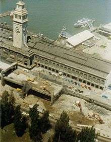
Embarcadero Structure in 1978
-

Ramps and interchanges between Bay Bridge, I-80, and the Embarcadero Freeway prior to the 1989 earthquake
-
Embarcadero Freeway around 1988
-
Embarcadero Freeway in February 1982
Exit list
The following is an exit list of the former Embarcadero Freeway prior to the Loma Prieta earthquake and subsequent demolition.
The entire route was in San Francisco.
| mi | km | Destinations | Notes | ||||
|---|---|---|---|---|---|---|---|
| Southbound exit and northbound entrance | |||||||
| Southbound exit and northbound entrance | |||||||
| Main Street | Northbound exit | ||||||
| Beale Street | Southbound entrance | ||||||
| Washington Street | Northbound exit | ||||||
| Clay Street | Southbound entrance | ||||||
| Broadway, Battery Street | Northbound exit | ||||||
| Broadway, Sansome Street | Southbound entrance | ||||||
| Gap in route | |||||||
| Marina Blvd | Continuation beyond U.S. 101 | ||||||
| Northbound exit and southbound entrance | |||||||
| 1.000 mi = 1.609 km; 1.000 km = 0.621 mi | |||||||
References
- 1 2 3 4 "Former State Route 480". California Highways. Retrieved 2013-01-26.
- ↑ "Interstate 480". kurumi.com. Retrieved 2013-01-26.
- ↑ "California Highways: Chronology of California Highways 1947-1962". Cahighways.org. Retrieved 2013-01-26.
- ↑ "1963 San Francisco inset map". Retrieved 2013-01-26.
- ↑ "South Access to the Golden Gate Bridge". Presidio Parkway. Retrieved 2013-01-26.
- 1 2 "California Highways: Interstate Highway Types and the History of California's Interstates". Cahighways.org. Retrieved 2013-01-26.
- 1 2 "I-480 (canceled) California". kurumi. Retrieved 2013-01-26.
- 1 2 3 "California Highways: Former State Route 480". Cahighways.org. Retrieved 2013-01-26.
- ↑ San Francisco Chronicle, May 18, 1964 Page One
- ↑ Transportation Section of the Master Plan of the City and County of San Francisco, 1955, OCLC 51930208 (map with route numbers added)
- ↑ "San Francisco Freeway Plan", 1964 [Revised from 1955 plan] San Francisco Department of City Planning map
- ↑ "January 1, 2006 California Log of Bridges on State Highways". Dot.ca.gov. Retrieved 2013-01-26.
- ↑ Wildermuth, John (2009-09-19). "Chinatown's champion". San Francisco Chronicle. Retrieved 2016-09-19.
- ↑ "San Francisco, CA - Embarcadero Freeway". Preservation Institute. Retrieved May 31, 2014.
- 1 2 3 Agnos, Art (October 17, 2009). "Reflections on the Loma Prieta Earthquake, 20 Years Later". Huffington Post. Retrieved June 8, 2014.
- 1 2 3 King, John (October 17, 2004). "15 SECONDS THAT CHANGED SAN FRANCISCO / The sweeping makeover that transformed the city began 15 years ago today with the Loma Prieta earthquake.". San Francisco Chronicle. Retrieved June 8, 2014.
- ↑ Quake Renews Embarcadero Freeway Fight - San Francisco Chronicle November 16, 1989, Front page
- ↑ "FHWA By Day - February 27". Fhwa.dot.gov. 1991-02-27. Retrieved 2013-01-26.
- ↑ "California Highways: Interstate 280". Cahighways.org. Retrieved 2013-01-26.
- ↑ Bay Bridge Info. "Bay Bridge Seismic Safety Project". Baybridgeinfo.org. Retrieved 2013-01-26.
- ↑ King, John (October 17, 2004). "15 SECONDS THAT CHANGED SAN FRANCISCO / The sweeping makeover that transformed the city began 15 years ago today with the Loma Prieta earthquake.". San Francisco Chronicle. Retrieved May 31, 2014.
- ↑ "Sue Bierman Park". San Francisco Recreation & Parks Department.
- 1 2 "Grand Opening of Pier 14 Public Pier and Dedication Ceremony to former Mayor Art Agnos". Port of San Francisco. June 15, 2006. Retrieved May 31, 2014.
- ↑ "Rincon Park Opens Today: City's Newest Two-Acre Park and Public Open Space on the S.F. Waterfront" (PDF) (Press release). Port of San Francisco. February 13, 2003. Retrieved May 31, 2014.
- ↑ "Brannan Street Wharf". Port of San Francisco. Retrieved May 31, 2014.
- ↑ "Broadway-Sansome Apartments". Chinatown Community Development Center. Retrieved May 31, 2014.
- ↑ "Transbay Transit Center - Redevelopment Plan". Retrieved April 11, 2013.
- ↑ King, John (October 22, 2004). "15 seconds that changed San Francisco / A generation ago, the city had a fear of heights. But now, on land cleared by Loma Prieta, new high-rises are getting the chance to soar.". San Francisco Chronicle. Retrieved May 31, 2014.
- ↑ "Case Studies in Urban Freeway Removal (Seattle Urban Mobility Plan)" (PDF). January 2008.
- ↑ "Retiring Infrastructure" (PDF). MassDOT. September 13, 2011.
- ↑ Adelman, Michelle (February 22, 2014). "Looking for the future of the Gardiner Expressway". CBC News. Retrieved May 31, 2014.
- ↑ Eskenazi, Joe (February 12, 2014). "The Next Big Thing: Should the People Control the Fate of the Waterfront?". SF Weekly. Retrieved May 31, 2014.
- ↑ A View to a Kill (1985) - Filming locations
- ↑ "Miracle on I-880 (Original Trailer)". YouTube.
External links
- San Francisco Chronicle photo of the freeway from 1987
- Congress for the New Urbanism History of Embarcadero
- California Highways (www.cahighways.org) San Francisco-Bay Area Freeway Development (Part 1—The City of San Francisco)
- YouTube - 1984 drive on the San Francisco Embarcadero Freeway (5:29)
- Map of Golden Gate Freeway route alternatives from 1965
| ||