California State Route 198
| ||||
|---|---|---|---|---|
 | ||||
| Route information | ||||
| Defined by Streets and Highways Code § 498 | ||||
| Maintained by Caltrans | ||||
| Length: |
141.273 mi[1] (227.357 km) (plus about 8.5 mi (14 km) on SR 33) | |||
| Major junctions | ||||
| West end: |
| |||
|
| ||||
| East end: | Sequoia National Park | |||
| Highway system | ||||
| ||||

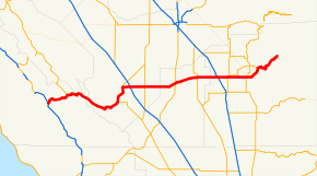
State Route 198 (SR 198) is an east–west state highway that begins at U.S. Route 101 (US 101) south of King City and ends in Sequoia National Park. It connects the California Central Coast to the mid–Central Valley through Hanford and Visalia, although the most developed portion is in the Central Valley itself. SR 198 intersects the major north–south routes in the Central Valley, including Interstate 5 (I-5), SR 33, and SR 99. The highway that would become SR 198 was approved for construction in the 1910s through three bond issues, and was added to the state highway system in 1934. Parts of the highway were upgraded to freeway during the 1960s. Another portion is being converted to an expressway in between Hanford and Visalia, with completion scheduled for late 2012.
Route description
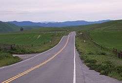
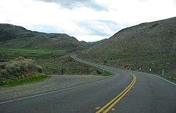
The road begins at a remote interchange with US 101 south of King City in the Salinas River Valley. Leaving US 101, SR 198 passes through the Priest Valley, climbs the Diablo Range as a two-lane road and crosses over an unnamed pass. It then descends along Warthan Canyon to the town of Coalinga in the agricultural Central Valley, where it briefly runs concurrently with SR 33. On both sides of Coalinga the road passes through the enormous Coalinga Oil Field.[2]
SR 198 then intersects Interstate 5 (I-5) in Fresno County near the Harris Ranch Airport before becoming a freeway west of Lemoore. The landscape becomes a bit less rural as it goes through Hanford and passes near the Hanford Municipal Airport, where it continues as a four-lane expressway from the intersection with SR 43 until SR 198 encounters a freeway-to-freeway interchange with SR 99 as it enters Visalia, the largest city it passes through, and goes by the Visalia Municipal Airport. It remains a freeway until east of Visalia, intersecting SR 65 and passing by College of the Sequoias. The road starts to climb the forested Sierra Nevada and ends at Sequoia National Park, near Lake Kaweah.[2] This is one of the main routes providing access to Sequoia National Park, the other being SR 180 to the north.[3]
SR 198 is part of the California Freeway and Expressway System[4] and is eligible for the State Scenic Highway System as designated by the California State Legislature;[5] however, it is not a scenic highway as defined by Caltrans.[6]
History
All of SR 198 was added to the state highway system in the three bond issues floated to pay for the construction of the system. The first bond issue, approved by the state's voters in 1910, included the road from Visalia west to Hanford, connecting the two county seats with the central north–south highway (Route 4, now SR 99). As part of the 1916 bond issue, the route was extended west from Hanford through Coalinga to the coast trunk highway (Route 2, now US 101) near San Lucas, and assigned it the Route 10 designation. The third bond issue, passed in 1919, included a further extension east from Visalia to Sequoia National Park.[7] The entire length of Route 10 was marked as Sign Route 198 in 1934,[8] and this number was adopted legislatively in the 1964 renumbering.[9] The portion east of Interstate 5 near Coalinga was added to the California Freeway and Expressway System in 1959,[10] and parts of it have been built as such. The construction of the freeway east of Visalia to Road 192 was approved in January 1961, with the remainder of the freeway unplanned at that time as contingent on the routing of SR 65.[11] The projected cost in 1958 of the entire freeway east of Visalia was $13 million ($262 million in today's dollars) and was scheduled to be completed by 1964.[12] The freeway through Visalia was completed by 1965, with an expressway connecting it to US 99. Also completed was the expressway heading west out of Hanford, with part of it access-controlled west of Lemoore.[13][14]
Construction began in November 2009 on a project to widen a two-lane, 10-mile section of SR 198 between SR 43 and SR 99 into a four-lane expressway. The $60 million project was completed in December 2012.[15]
Future
The Kings County Association of Governments has plans to improve the state highways within the county. Developers are interested in building distribution warehouses in Kings County because of its strategic location midway between the Los Angeles and San Francisco Bay areas, but they are currently turned off by the lack of freeway access. For SR 198, the plan is to extend the freeway segment from Naval Air Station Lemoore to I-5. However, Kings County voters have shown little interest in passing any transportation taxes to fund these projects.[16]
Major intersections
Except where prefixed with a letter, postmiles were measured on the road as it was in 1964, based on the alignment that existed at the time, and do not necessarily reflect current mileage. R reflects a realignment in the route since then, M indicates a second realignment, L refers an overlap due to a correction or change, and T indicates postmiles classified as temporary (for a full list of prefixes, see the list of postmile definitions).[1] Segments that remain unconstructed or have been relinquished to local control may be omitted. The numbers reset at county lines; the start and end postmiles in each county are given in the county column.
| County | Location | Postmile [1][17][18] | Exit [19] | Destinations | Notes |
|---|---|---|---|---|---|
| Monterey MON R0.00-25.79 | San Lucas | R0.00 | Lockwood-San Lucas Road, Bunte Road | Continuation beyond US 101 | |
| R0.11 | Interchange; west end of SR 198; US 101 exit 273 | ||||
| | 14.00 | ||||
| Fresno FRE 0.00-42.73 | Coalinga | 22.65 15.71[N 1] | West end of SR 33 overlap | ||
| | 24.32[N 1] 22.66 | East end of SR 33 overlap | |||
| | 26.81 | Interchange; I-5 exit 334 | |||
| | 34.66 | ||||
| Kings KIN 0.00-28.33 | | 3.01 | Lemoore NAS | ||
| | | West end of freeway | |||
| | 4.99 | 73 | Stratford, Avenal | ||
| Lemoore | R8.90 | 77 | |||
| | 78 | 19th Avenue | |||
| R10.56 | 79 | 18th Avenue, Lemoore Avenue – Central Lemoore | |||
| | R12.11 | 81 | Houston Avenue, D Street – Lemoore | ||
| | R14.77 | 83 | 14th Avenue – Armona | ||
| | R15.75 | 84 | Hanford-Armona Road, 13th Avenue – Armona | ||
| Hanford | R16.91 | 85 | 12th Avenue | ||
| R17.91 | 86 | 11th Avenue – Hanford | Eastbound exit and westbound entrance | ||
| R18.3 | 87A | Redington Street – Central Hanford | Westbound exit and entrance | ||
| R18.51 | 87 | Douty Street – Central Hanford | No westbound exit | ||
| R18.96 | 87B | 10th Avenue | Westbound exit and eastbound entrance | ||
| | | Short gap in freeway | |||
| | R20.98 | 89 | |||
| | | East end of freeway | |||
| Tulare TUL 0.00-44.16 | | | West end of freeway | ||
| | R3.83 | 101 | Signed as exits 101A (south) and 101B (north) westbound; former US 99; SR 99 north exits 96-97, south exit 97 | ||
| Visalia | R4.80 | 102 | Plaza Drive | ||
| 5.76 | 103 | Shirk Road | |||
| 6.76 | 104 | Akers Street | |||
| 7.76 | 105A | Demaree Street | |||
| R8.75 | 105B | West end of SR 63 overlap | |||
| R9.97 | 107A | East end of SR 63 overlap | |||
| R10.73 | 107B | Ben Maddox Way – Woodlake | |||
| R11.72 | 108 | ||||
| | R13.74 | 110 | Road 156 – Ivanhoe | ||
| | R14.65 | 111 | Farmersville Boulevard – Farmersville | ||
| | | East end of freeway | |||
| | R18.76 | ||||
| | R19.76 | ||||
| | 27.96 | ||||
| | 44.16 | Sequoia National Park boundary | |||
1.000 mi = 1.609 km; 1.000 km = 0.621 mi
| |||||
References
- 1 2 3 California Department of Transportation. "State Truck Route List". Sacramento: California Department of Transportation. Archived from the original (XLS file) on June 30, 2015. Retrieved June 30, 2015.
- 1 2 Google (21 July 2012). "State Route 198" (Map). Google Maps. Google. Retrieved 21 July 2012.
- ↑ Staff. "Directions – Sequoia & Kings Canyon National Parks". National Park Service. Retrieved 21 July 2012.
- ↑ CA Codes (shc:250-257)
- ↑ CA Codes (shc:260-284)
- ↑ "Officially Designated State Scenic Highways and Historic Parkways". California Department of Transportation. December 7, 2007. Retrieved 21 July 2012.
- ↑ Howe & Peters, Engineers' Report to California State Automobile Association Covering the Work of the California Highway Commission for the Period 1911-1920, pp. 11-16
- ↑ California Highways and Public Works, State Routes will be Numbered and Marked with Distinctive Bear Signs, August 1934
- ↑ California State Assembly. "An act to add Section 253 and Article 3 (commencing with Section 300) to Chapter 2 of Division 1 of, and to repeal Section 253 and Article 3 (commencing with Section 300) of Chapter 2 of Division 1 of, the...". 1963 Session of the Legislature. Statutes of California. State of California. Ch. 385 p. 1185.
- ↑ California State Assembly. "An act to amend Sections 306, 320, 332, 351, 362, 365, 369, 374, 382, 388, 397, 407, 408, 409, 410, 415, 422, 435, 440, 446, 453, 456, 460, 467, 470, 476, 487, 492, 493, 494, 506, 521, 528, and 529...". 1959 Session of the Legislature. Statutes of California. State of California. Ch. 1062 p. 3112.: "Route 10 from Route 238 [I-5] near Coalinga to Sequoia National Park."
- ↑ "Highway Route 198 East of Visalia Is Approved". Los Angeles Times. 20 January 1961. p. 27.
- ↑ "$13 Million Freeway Outlined". Los Angeles Times. 19 September 1958. p. 24.
- ↑ California State Highways (Map). California Division of Highways. 1961.
- ↑ California (Map). Shell Oil Company. 1965.
- ↑ Eiman, Mark (December 19, 2012). "Caltrans celebrates Hanford Expressway opening". The Sentinel. Hanford, California. Retrieved December 19, 2012.
- ↑ Nidever, Seth (September 7, 2013). "Road map for the future?". The Sentinel. Retrieved March 23, 2016.
- ↑ California Department of Transportation, Log of Bridges on State Highways, July 2007
- ↑ California Department of Transportation, All Traffic Volumes on CSHS, 2005 and 2006
- ↑ California Department of Transportation, California Numbered Exit Uniform System, State Route 198 Freeway Interchanges, Retrieved on 2009-02-07.
External links
| Wikimedia Commons has media related to California State Route 198. |
- California @ AARoads.com - State Route 198
- Caltrans: Route 198 highway conditions
- California Highways: SR 198