Caloosahatchee Bridge
| Caloosahatchee Bridge | |
|---|---|
 | |
| Coordinates | 26°38′45.59″N 81°52′29.67″W / 26.6459972°N 81.8749083°WCoordinates: 26°38′45.59″N 81°52′29.67″W / 26.6459972°N 81.8749083°W |
| Carries |
|
| Crosses | Caloosahatchee River |
| Locale | Fort Myers, Florida |
| Maintained by | Florida Department of Transportation |
| Characteristics | |
| Design | Concrete girder bridge |
| Clearance below | 55 ft (16.8 m) |
| History | |
| Opened | 1964 |
| Statistics | |
| Toll | None |
The Caloosahatchee Bridge is a bridge located in Fort Myers, Florida. It carries U.S. Highway 41 (US 41, locally known as Cleveland Avenue) over the Caloosahatchee River, which is where its name comes from. The bridge has four lanes and is 55 feet (17 m) tall.
History

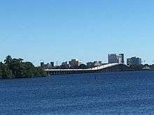
The Caloosahatchee Bridge was built in 1962 but it did not open for traffic until 1964. The bridge's opening was delayed due to difficult negotiations with landowners at the south side over land needed to connect the bridge to Cleveland Avenue.[1]
The opening of the bridge changed the routing of US 41 to bypass downtown Fort Myers. Originally, US 41 went though downtown Fort Myers, and crossed the Caloosahatchee River on the Edison Bridge, which at the time was a two-lane drawbridge. The old route was then designated as the US 41 Business.
The south side of the bridge passes over Centennial Park, as well as First Street, the main road through downtown Fort Myers. A loop ramp connects the southbound lanes of the bridge to First Street. Directly south of the bridge is US 41's intersection with State Road 867 (SR 867), SR 80, and SR 82. Each of these highways terminate at this intersection. A two-lane overpass constructed with the Caloosahatchee Bridge crosses this intersection, which is historically known as the Five Points interchange, since it is a five-way interchange. The overpass originally carried both northbound and southbound traffic from the bridge, but was changed to have both lanes carry northbound traffic in the early 1990s.[2]
See also
-
 Bridges portal
 -
 Florida portal
 - List of crossings of the Caloosahatchee River
References
- ↑ Board, Prudy Taylor; Bartlett, Patricia Pope (1985). Lee County: A Pictorial History. Norfolk, VA: Donning Company. ISBN 0-89865-443-2.
- ↑ "U.S. Highway 41 North - Lee County". Florida @ SouthEastRoads. Retrieved 2011-06-08.
| Crossings of the Caloosahatchee River | ||||
|---|---|---|---|---|
| ||||