Campobello di Mazara
Not to be confused with Campobello di Licata.
| Campobello di Mazara | |
|---|---|
| Comune | |
| Comune di Campobello di Mazara | |
|
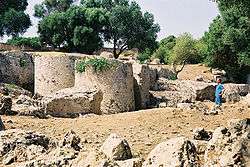
Rocks of Cusa | |
 Campobello di Mazara Location of Campobello di Mazara in Italy | |
| Coordinates: 37°38′N 12°45′E / 37.633°N 12.750°ECoordinates: 37°38′N 12°45′E / 37.633°N 12.750°E | |
| Country | Italy |
| Region |
|
| Province / Metropolitan city | Trapani (TP) |
| Frazioni | Tre Fontane, Torretta Granitola |
| Government | |
| • Mayor | Cirò Caravà (since June 27, 2006) |
| Area | |
| • Total | 65 km2 (25 sq mi) |
| Elevation | 110 m (360 ft) |
| Population (2004) | |
| • Total | 11,190 |
| • Density | 170/km2 (450/sq mi) |
| Demonym(s) | Campobellesi |
| Time zone | CET (UTC+1) |
| • Summer (DST) | CEST (UTC+2) |
| Postal code | 91021 |
| Dialing code | 0924 |
| Patron saint | St. Vitus |
| Saint day | June 15 |
| Website | Official website |
Campobello di Mazara (Sicilian: Campubbeddu) is an Italian town in Sicily, part of the province of Trapani.
Overview
Its inhabitants are scattered in the town center and the minor seaside frazioni of Tre Fontane and Torretta Granitola, populated mostly during the summer period. It borders on the neighbouring cities of Mazara del Vallo and Castelvetrano, and is colloquially known just as Campobello.
Main sights
- Cave di Cusa
- The Clocktower
- Palazzo Accardi
- Hotel Club Ramuxara
References
External links
![]() Media related to Campobello di Mazara at Wikimedia Commons
Media related to Campobello di Mazara at Wikimedia Commons
This article is issued from Wikipedia - version of the 10/16/2015. The text is available under the Creative Commons Attribution/Share Alike but additional terms may apply for the media files.
