Canisteo River
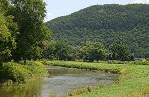
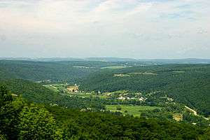
The Canisteo River is a 61.0-mile-long (98.2 km)[1] tributary of the Tioga River in western New York in the United States. It drains a dissected plateau, a portion of the northern Allegheny Plateau southwest of the Finger Lakes region, in the far northwestern reaches of the watershed of the Susquehanna River.
It rises in the hills of northern Allegany County, approximately 15 miles (24 km) southwest of Dansville. It flows east into northern Steuben County, then generally southeast past Hornell and Canisteo. It joins the Tioga from the west in southeastern Steuben County, approximately 10 miles (16 km) north of the Pennsylvania state line and 5 miles (8 km) southwest of Corning.
The name of the river comes from a Native American word meaning either "pickerel" or "head of water". In the 19th century the river valley was the site of an early timber industry. Logs were floated down the river after being cut. As on other rivers in the Susquehanna basin, transportation on the Canisteo before the middle 19th century was often accomplished by arks up to 75 feet (23 m) long. The headwaters of the Canisteo were considered to be the farthest navigable headwaters of ark navigation in the Susquehanna watershed.
See also
References
- ↑ U.S. Geological Survey. National Hydrography Dataset high-resolution flowline data. The National Map Archived 2012-04-05 at WebCite, accessed August 8, 2011
External links
- Canisteo River history
- Rootsweb: Canisteo River settlement
- Ark Navigation on the Canisteo
- Susquehanna River arks


Coordinates: 42°23′22.8″N 77°43′50″W / 42.389667°N 77.73056°W