Cape Leeuwin
| Cape Leeuwin Western Australia | |
|---|---|
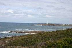
 Cape Leeuwin and the Cape Leeuwin Lighthouse as seen from the north | |
 Cape Leeuwin | |
| Coordinates | 34°22′27″S 115°08′09″E / 34.37417°S 115.13583°ECoordinates: 34°22′27″S 115°08′09″E / 34.37417°S 115.13583°E |
Cape Leeuwin ![]() i/ˈluːwɪn/ is the most south-westerly mainland point of the Australian Continent, in the state of Western Australia.
i/ˈluːwɪn/ is the most south-westerly mainland point of the Australian Continent, in the state of Western Australia.
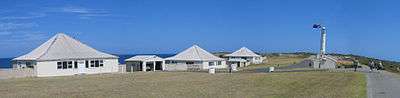
A few small islands and rocks, the St Alouarn Islands, extend further to the south. The nearest settlement, north of the cape, is Augusta. South-east of Cape Leeuwin, the coast of Western Australia goes much further south. Located on headland of the cape is the Cape Leeuwin Lighthouse and the buildings that were used by the lighthouse keepers.
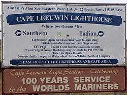
In Australia, the Cape is considered the point where the Indian Ocean meets the Southern Ocean; however most other nations and bodies consider the Southern Ocean to only exist south of 60°S.[1]
Use of name
Cape Leeuwin is often grouped with the next headland north, Cape Naturaliste, to identify the geography and ecology of the region. One example is in the name Leeuwin-Naturaliste National Park. Another is in the use of the phrases Cape to Cape or the Capes in tourist promotional materials. A shore base and a ship of the Royal Australian Navy have been named HMAS Leeuwin after the cape.
History
Matthew Flinders named Cape Leeuwin after the first known ship to have visited the area is the Leeuwin ("Lioness"), a Dutch vessel that charted some of the nearby coastline in 1622. The log of the Leeuwin has been lost, so very little is known of the voyage. However, the land discovered by the Leeuwin was recorded on a 1627 map by Hessel Gerritsz: Caert van't Landt van d'Eendracht ("Chart of the Land of Eendracht"), which appears to show the coast between present-day Hamelin Bay and Point D’Entrecasteaux.[2] Cape Leeuwin itself cannot be recognised.
Other European vessels passed by for the next two centuries, including the Dutch 't Gulden Zeepaert, commanded by François Thijssen, in 1627 and the French Gros Venture, under Louis Aleno de St Aloüarn, in 1772.
The first known sighting of the cape was by Bruni d'Entrecasteaux in 1791. d'Entrecasteaux thought the cape was an island, and named it "Isle St Allouarn" ("St Allouarn Island"), in honour of Captain de St Aloüarn. Ten years later, Matthew Flinders began his survey of the South coast of New Holland from Cape Leeuwin in 1801 when he named it. Flinders landed in the bay to the east of Cape Leeuwin, today’s Flinders Bay. Flinders was aware that the area had been known to the Dutch as "Leeuwin's Land".
At two in the morning we had 80 fathoms, and veered towards the land. It was seen from the masthead at five; and the highest part, the same which had been set in the evening, bore N. 12° W. This is the largest of the before-mentioned Isles of St Alouarn; but at half past seven we saw hills extending from behind, and, to all appearance, joining it to the mainland. This supposed isle is, therefore, what I denominate "Cape Leeuwin", as being the south-western and most projecting part of Leeuwin's Land.[3]
The St Alouarn Islands is a group of islands off the tip of Cape Leeuwin.[2]
Climate
| Climate data for Cape Leeuwin | |||||||||||||
|---|---|---|---|---|---|---|---|---|---|---|---|---|---|
| Month | Jan | Feb | Mar | Apr | May | Jun | Jul | Aug | Sep | Oct | Nov | Dec | Year |
| Record high °C (°F) | 41.0 (105.8) |
42.8 (109) |
39.9 (103.8) |
35.0 (95) |
29.3 (84.7) |
24.5 (76.1) |
22.5 (72.5) |
24.0 (75.2) |
27.8 (82) |
31.8 (89.2) |
36.1 (97) |
38.4 (101.1) |
42.8 (109) |
| Average high °C (°F) | 23.1 (73.6) |
23.4 (74.1) |
22.7 (72.9) |
21.3 (70.3) |
19.2 (66.6) |
17.4 (63.3) |
16.4 (61.5) |
16.4 (61.5) |
17.1 (62.8) |
18.2 (64.8) |
20.1 (68.2) |
21.8 (71.2) |
19.8 (67.6) |
| Average low °C (°F) | 17.0 (62.6) |
17.3 (63.1) |
16.7 (62.1) |
15.5 (59.9) |
13.7 (56.7) |
12.2 (54) |
11.3 (52.3) |
11.2 (52.2) |
11.8 (53.2) |
12.6 (54.7) |
14.2 (57.6) |
15.8 (60.4) |
14.1 (57.4) |
| Record low °C (°F) | 9.4 (48.9) |
10.0 (50) |
8.0 (46.4) |
7.2 (45) |
5.3 (41.5) |
3.3 (37.9) |
4.4 (39.9) |
5.0 (41) |
4.2 (39.6) |
4.3 (39.7) |
5.8 (42.4) |
9.4 (48.9) |
3.3 (37.9) |
| Average precipitation mm (inches) | 16.1 (0.634) |
15.7 (0.618) |
27.9 (1.098) |
59.7 (2.35) |
138.7 (5.461) |
176.1 (6.933) |
181.4 (7.142) |
135.8 (5.346) |
91.3 (3.594) |
64.6 (2.543) |
37.1 (1.461) |
20.8 (0.819) |
965.8 (38.024) |
| Average precipitation days | 6.0 | 5.9 | 8.8 | 13.2 | 19.7 | 22.2 | 24.6 | 23.3 | 20.2 | 16.8 | 11.2 | 8.1 | 180.0 |
| Average relative humidity (%) | 72 | 74 | 74 | 75 | 76 | 77 | 77 | 75 | 75 | 75 | 74 | 73 | 75 |
| Source: [3] | |||||||||||||
National Park
The hillside to the west of the lighthouse, and the land nearby is now part of Leeuwin-Naturaliste National Park. It has extensive heath vegetation and thick scrub which supports a very high number of plant species and also bird species that utilise this habitat. The bay just east of Cape Leeuwin is Flinders Bay, named after Matthew Flinders, the circumnavigating explorer of the early 19th century.
Wrecks
Shipwrecks within sight of this location include SS Pericles, an iron-screw steamer built in Belfast in Northern Ireland, which sank after hitting an uncharted rock on a clear calm day in 1910. The wreck was found by Tom Snider in 1957 at 34°25.33′S 115°08.24′E. He dived on the wreck to recover the lead that was being carried by the ship.
Some shipwrecks are identified as being within the vicinity of Augusta, Cape Leeuwin or Hamelin Bay that might not be within visual distance of the lighthouse.
Notes
- ↑ "Southern Ocean". World Factbook. CIA. 22 October 2009. Retrieved 9 January 2010.
- ↑ Flinders, Matthew. A voyage to Terra Australis, Volume 1 (Project Gutenberg edition ed.). London: G. & W. Nicol.
- ↑ "Climate statistics for Cape Leeuwin". Bureau of Meteorology. Retrieved December 2014. Check date values in:
|access-date=(help)
Further reading
- CALM/DOLA 1996. Land Management Series Map Sheet 1929-3 Leeuwin Edition 11:50000.
- (Edward Duyker (1987) The Dutch in Australia, AE Press, Melbourne.
- (Edward Duyker & Maryse Duyker, ed. & trans) (2001) Bruny d’Entrecasteaux: Voyage to Australia and the Pacific 1791—1793, Miegunyah/Melbourne University Press, Melbourne. ISBN 0-522-84932-6
- Edward Duyker,(2006) François Péron: An Impetuous Life: Naturalist and Voyager, Miegunyah/MUP, Melb. ISBN 978-0-522-85260-8,
- Eakin,Morgan (2003)Very Much on Watch - The Percy Willmott Photos Thornlie, W.A. Blackwood Publishing. ISBN 0-646-49939-4
- Fornasiero, Jean; Monteath, Peter and West-Sooby, John. (2004) Encountering Terra Australis: the Australian voyages of Nicholas Baudin and Matthew Flinders, Kent Town, South Australia, Wakefield Press ISBN 1-86254-625-8
- Fyfe, Christopher (1999) Uncharted end : the Pericles disaster An address to the Royal Western Australian Historical Society on 23 June 1999.
- Horner, Frank (1987) The French Reconnaissance: Baudin in Australia 1801—1803, Melbourne University Press, Melbourne, ISBN 0-522-84339-5.
External links
- "Cape Leeuwin Lighthouse". Lighthouses of Western Australia. Lighthouses of Australia Inc.
- - List of WA lighthouses - check link to Cape Leeuwin