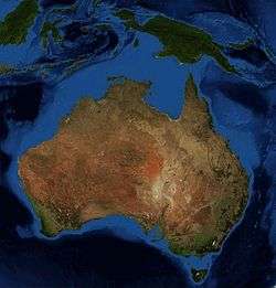
Australia (continent)
.svg.png) | |
| Area | 8,600,000 km2 (3,300,000 sq mi) (7th) |
|---|---|
| Population | 36,000,000 (estimated population of Australia, Papua New Guinea, Papua, West Papua, Maluku Islands, Timor, Halmahera, etc. for 2009, 6th) |
| Pop. density | 4.2/km2 (11/sq mi) |
| Demonym | Australian |
| Countries | 4 (Australia, Papua New Guinea, East Timor* and portions of Indonesia) |
| Languages | English, Indonesian, Tok Pisin, Hiri Motu, 269 indigenous Papuan and Austronesian languages, Mandarin Chinese, Italian, Arabic, Greek, Cantonese and about 70 Indigenous Australian languages |
| Time zones | GMT+10, GMT+9.30, GMT+8 |
| Internet TLD | .au, .pg, .tl, .tp and .id |
| Largest cities |
List of cities in Australia by population List
|
Australia, sometimes known in technical contexts by the names Sahul, Australinea or Meganesia, to distinguish it from the Australian mainland, is a continent comprising mainland Australia, Tasmania, New Guinea, Seram, possibly Timor, and neighbouring islands.
It is the smallest of the seven traditional continents in the English conception. The continent lies on a continental shelf overlain by shallow seas which divide it into several landmasses—the Arafura Sea and Torres Strait between mainland Australia and New Guinea, and Bass Strait between mainland Australia and Tasmania. When sea levels were lower during the Pleistocene ice age, including the Last Glacial Maximum about 18,000 BC, they were connected by dry land. During the past 10,000 years, rising sea levels overflowed the lowlands and separated the continent into today's low-lying arid to semi-arid mainland and the two mountainous islands of New Guinea and Tasmania. Geologically, a continent extends to the edge of its continental shelf, so the now-separate islands are considered part of the continent.[1] Due to the spread of animals, fungi and plants across the single Pleistocene landmass the separate lands have a related biota.
New Zealand is not part of the continent of Australia, but of the separate, submerged continent of Zealandia.[2] New Zealand and Australia are both part of the wider regions known as Australasia and Oceania. The term Oceania is often used to denote the region encompassing the Australian continent and various islands in the Pacific Ocean that are not included in the seven-continent model.
Geography and name
With a total land area of 8.56 million square kilometres (3,310,000 sq mi), the Australian continent is the smallest and lowest-lying human-inhabited continent on Earth.[3] The continental shelf connecting the islands, half of which is less than 50 metres (160 ft) deep, covers some 2.5 million square kilometres (970,000 sq mi), including the Sahul Shelf[4][5] and Bass Strait. As the country of Australia is mostly on a single landmass, and comprises most of the continent, it is sometimes informally referred to as an island continent, surrounded by oceans.[6]
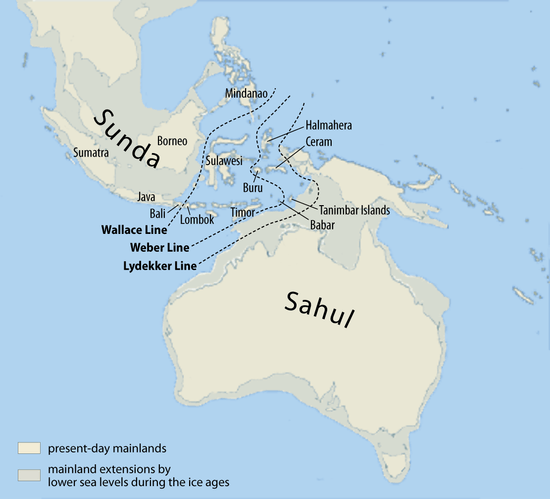
Archaeological terminology for this region has changed repeatedly. Prior to the 1970s, the single Pleistocene landmass was called Australasia,[7] derived from the Latin australis, meaning "southern", although this word is most often used for a wider region that includes lands like New Zealand that are not on the same continental shelf. In the early 1970s, the term Greater Australia was introduced for the Pleistocene continent.[7] Then at a 1975 conference and consequent publication,[8] the name Sahul was extended from its previous use for just the Sahul Shelf to cover the continent.[7]
In 1984 W. Filewood suggested the name Meganesia, meaning "great island" or "great island-group", for both the Pleistocene continent and the present-day lands,[9] and this name has been widely accepted by biologists.[10] Others have used Meganesia with different meanings: travel writer Paul Theroux included New Zealand in his definition[11] and others have used it for Australia, New Zealand and Hawaii.[12] Another biologist, Richard Dawkins, coined the name Australinea in 2004.[13] Australia-New Guinea has also been used.[14]
Geology
The continent primarily sits on the Indo-Australian Plate. Because of its central location on its tectonic plate Australia doesn't have any active volcanic regions, the only continent with this distinction.[15] The lands were joined with Antarctica as part of the southern supercontinent Gondwana until the plate began to drift north about 96 million years ago. For most of the time since then, Australia–New Guinea remained a continuous landmass. When the last glacial period ended in about 10,000 BC, rising sea levels formed Bass Strait, separating Tasmania from the mainland. Then between about 8,000 and 6,500 BC, the lowlands in the north were flooded by the sea, separating New Guinea, the Aru Islands, and the Australian mainland.
A northern arc consisting of the New Guinea Highlands, the Raja Ampat Islands, and Halmahera was uplifted by the northward migration of Australia and subduction of the Pacific Plate. The Outer Banda Arc was accreted along the northwestern edge the continent; it includes the islands of Timor, Tanimbar, and Seram.[16]
Biogeography
As the continent drifted north from Antarctica, a unique fauna, flora and mycobiota developed. Marsupials and monotremes also existed on other continents, but only in Australia–New Guinea did they out-compete the placental mammals and come to dominate. Bird life also flourished — in particular, the songbirds (order Passeriformes, suborder Passeri) are thought to have evolved 50 million years ago in the part of Gondwana that later became Australia, New Zealand, New Guinea, and Antarctica, before radiating into a great number of different forms and then spreading around the globe.[17] Among the fungi, the remarkable association between Cyttaria gunnii (one of the "golf-ball" fungi) and its associated trees in the genus Nothofagus is evidence of that drift: the only other places where this association is known are New Zealand and southern Argentina and Chile.[18]
Animal groups such as macropods, monotremes, and cassowaries are endemic to Australia. There were three main reasons for the enormous diversity that developed in animal, fungal and plant life.
- While much of the rest of the world underwent significant cooling and thus loss of species diversity, Australia–New Guinea was drifting north at such a pace that the overall global cooling effect was roughly equalled by its gradual movement toward the equator. Temperatures in Australia–New Guinea, in other words, remained reasonably constant for a very long time, and a vast number of different animal, fungal and plant species were able to evolve to fit particular ecological niches.
- Because the continent was more isolated than any other, very few outside species arrived to colonise, and unique native forms developed unimpeded.
- Finally, despite the fact that the continent was already very old and thus relatively infertile, there are dispersed areas of high fertility. Where other continents had volcanic activity and/or massive glaciation events to turn over fresh, unleached rocks rich in minerals, the rocks and soils of Australia–New Guinea were left largely untouched except by gradual erosion and deep weathering. In general, fertile soils produce a profusion of life, and a relatively large number of species/level of biodiversity. This is because where nutrients are plentiful, competition is largely a matter of outcompeting rival species, leaving great scope for innovative co-evolution as is witnessed in tropical, fertile ecosystems. In contrast, infertile soils tend to induce competition on an abiotic basis meaning individuals all face constant environmental pressures, leaving less scope for divergent evolution, a process instrumental in creating new species.
For about 40 million years Australia–New Guinea was almost completely isolated. During this time, the continent experienced numerous changes in climate, but the overall trend was towards greater aridity. When South America eventually separated from Antarctica, the development of the cold Antarctic Circumpolar Current changed weather patterns across the world. For Australia–New Guinea, it brought a marked intensification of the drying trend. The great inland seas and lakes dried out. Much of the long-established broad-leaf deciduous forest began to give way to the distinctive hard-leaved sclerophyllous plants that characterise the modern Australian landscape.
For many species, the primary refuge was the relatively cool and well-watered Great Dividing Range. Even today, pockets of remnant vegetation remain in the cool uplands, some species not much changed from the Gondwanan forms of 60 or 90 million years ago.
Eventually, the Australia–New Guinea tectonic plate collided with the Eurasian plate to the north. The collision caused the northern part of the continent to buckle upwards, forming the high and rugged mountains of New Guinea and, by reverse (downwards) buckling, the Torres Strait that now separates the two main landmasses. The collision also pushed up the islands of Wallacea, which served as island 'stepping-stones' that allowed plants from Southeast Asia's rainforests to colonise New Guinea, and some plants from Australia–New Guinea to move into Southeast Asia. The ocean straits between the islands were narrow enough to allow plant dispersal, but served as an effective barrier to exchange of land mammals between Australia–New Guinea and Asia.
Although New Guinea is the most northerly part of the continent, and could be expected to be the most tropical in climate, the altitude of the New Guinea highlands is such that a great many animals and plants that were once common across Australia–New Guinea now survive only in the tropical highlands where they are severely threatened by overpopulation pressures.
Human habitation
Humans first populated eastern Wallacea (including Timor, which at the time was separated from mainland Sahul), the rest of Sahul, and the Bismarck Archipelago from Sunda around 45,000 years ago, by a founding population estimated to have been at least several hundred, and having had relatively sophisticated water craft.[19] There was little subsequent population mixing between Wallacea and Sahul for about 30,000 years, and indeed relatively little mixing between the north and south and the east and west of Sahul after the initial dispersal of the population.
See also
References
- ↑ Johnson, David Peter (2004). The Geology of Australia. Port Melbourne, Victoria: Cambridge University Press. p. 12.
- ↑ Keith Lewis; Scott D. Nodder and Lionel Carter (2007-01-11). "Zealandia: the New Zealand continent". Te Ara Encyclopedia of New Zealand. Retrieved 2007-02-22.
- ↑ Mocomi. "Continents of the World". Mocomi. Retrieved 2014-10-28.
- ↑ "Big Bank Shoals of the Timor Sea: An environmental resource atlas". Australian Institute of Marine Science. 2001. Archived from the original on 8 September 2006. Retrieved 2006-08-28.
- ↑ Wirantaprawira, Dr Willy (2003). "Republik Indonesia". Dr Willy Wirantaprawira. Retrieved 2006-08-28.
- ↑ Löffler, Ernst; A.J. Rose, Anneliese Löffler & Denis Warner (1983). Australia:Portrait of a Continent. Richmond, Victoria: Hutchinson Group. p. 17. ISBN 0-09-130460-1.
- 1 2 3 Ballard, Chris (1993). "Stimulating minds to fantasy? A critical etymology for Sahul". Sahul in review: Pleistocene archaeology in Australia, New Guinea and island Melanesia. Canberra: Australian National University. pp. 19–20. ISBN 0-7315-1540-4.
- ↑ Allen, J.; J. Golson and R. Jones (eds) (1977). Sunda and Sahul: Prehistorical studies in Southeast Asia, Melanesia and Australia. London: Academic Press. ISBN 0-12-051250-5.
- ↑ Filewood, W. (1984). "The Torres connection: Zoogeography of New Guinea". Vertebrate zoogeography in Australasia. Carlisle, W.A.: Hesperian Press. pp. 1124–1125. ISBN 0-85905-036-X.
- ↑ e.g. Flannery, Timothy Fridtjof (1994). The future eaters: An ecological history of the Australasian lands and people. Chatswood, NSW: Reed. pp. 42, 67. ISBN 0-7301-0422-2.
- ↑ Theroux, Paul (1992). The happy isles of Oceania: Paddling the Pacific. London: Penguin. ISBN 0-14-015976-2.
- ↑ Wareham, Evelyn (September 2002). "From Explorers to Evangelists: Archivists, Recordkeeping, and Remembering in the Pacific Islands". Archival Science. 2 (3–4): 187–207. doi:10.1007/BF02435621.
- ↑ Dawkins, Richard (2004). The ancestor's tale: A pilgrimage to the dawn of evolution. Boston: Houghton Mifflin. p. 224. ISBN 0-618-00583-8.
- ↑ e.g. O'Connell, James F.; Allen, Jim (2007). "Pre-LGM Sahul (Pleistocene Australia-New Guinea) and the Archaeology of Early Modern Humans" (PDF). In Mellars, P.; Boyle, K.; Bar-Yosef, O.; Stringer, C. Rethinking the Human Revolution. Cambridge: McDonald Institute for Archaeological Research. pp. 395–410.
- ↑ Barrett; Dent (1996). Australian Environments: Place, Pattern and Process. Macmillan Education AU. p. 4. ISBN 0732931207. Retrieved 13 June 2014.
- ↑ MG Audley-Charles, 1986, "Timor–Tanimbar Trough: the foreland basin of the evolving Banda orogen", Spec. Publs int. Ass. Sediment, 8:91–102
- ↑ Low, T. (2014), Where Song Began: Australia's Birds and How They Changed the World, Tyre: Penguin Australia
- ↑ Korf, R.P. Cyttaria (Cyttariales): coevolution with Nothofagus, and evolutionary relationship to the Boedijnpezizeae (Pezizales, Sarcoscyphaceae). pp. 77–87 in K.A. Pirozynski & J. Walker [eds] Pacific Mycogeography: a Preliminary Approach. Australian Journal of Botany Supplementary Series No. 10, 172 pp. (1983).
- ↑ Allen, Jim; O'Connell, James F. (2008). "Getting from Sunda to Sahul". In Clark, Geoffrey; Leach, Foss; O'Connor, Sue. Islands of Inquiry: Colonisation, seafaring and the archaeology of maritime landscapes. Canberra: ANU Press. pp. 31–46.
Continents of the world | ||||||
|---|---|---|---|---|---|---|
| ||||||
.svg.png)
.svg.png)
.svg.png)
.svg.png)
.svg.png)
.svg.png)
.svg.png)
.svg.png)
Coordinates: 26°S 141°E / 26°S 141°E