César Chávez Park
| César Chávez Park | |
|---|---|
 | |
| Type | Urban park |
| Location | Berkeley, California |
| Coordinates | 37°52′21″N 122°19′10″W / 37.87241°N 122.31942°W |
| Area | 90 acres (36.42 ha) |
| Created | 1997 |
| Operated by | City of Berkeley, California |
| Open | 6 a.m. to 10 p.m. |
| Status | Open year round |

César Chávez Park is a 90 acres (36 ha) city park of Berkeley, California named after César Chávez.[1] It can be found on the peninsula on the north side of the Berkeley Marina in the San Francisco Bay and is adjacent to Eastshore State Park.
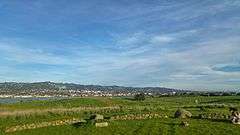
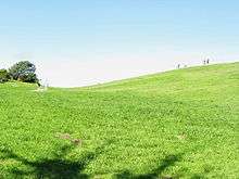
The park's east position in San Francisco Bay provides panoramic views of San Francisco, the Golden Gate Bridge, the Marin Headlands, and the east bay hills. The park's terrain is characterized by very open grassy hills that have become popular for kite flying.[2] Paved paths run the perimeter and throughout the park where picnic tables and barbecue grills are available to the public.
Features
- Grassy areas for kite flying, "Frisbee" playing, etc. (no officially designated sports fields).
- Hiking on trails throughout the park; the 1.25-mile (2.01 km) Dorothy Stegmann trail around the park’s perimeter is fully wheelchair accessible.
- Off-leash dog area (17 acre).
- Picnic tables with BBQ grills (several arranged for large groups).
- Solar Calendar.
- Wildlife sanctuary.
History

The park began as a landfill dating back to 1957, when dikes were constructed for the purpose of containing municipal waste. In 1969, the city adopted the Marina Master Plan, which set aside the landfill area for unstructured recreation. In 1991 the city completely sealed the landfill and the park opened soon thereafter, originally as North Waterfront Park. In 1996, the city renamed the park after César E. Chávez, union leader and founder of the United Farm Workers of America.[1]
Activities
Popular activities include model rocket launching, kite flying, picnicking, dog walking, jogging and walking. Although on a peninsula, the park has no access to the water because there are no beaches nor steps down through the park's reinforced shoreline.[1]
Events

- Solstice and Equinox celebrations at the Solar Calendar: Celebrations are held quarterly on the solstices and equinoxes. These celebrations include both scientific and cultural components. From the web site: "Many cultural celebrations are rooted in the cycles of the sun and moon, especially the solstices and equinoxes. For example, Easter, Passover, Narooz in the Spring, Rosh Hashanah, Kwaanza, Christmas in the winter, etc."[3]
- Fourth of July Celebration and Fireworks: While most of this event is held elsewhere in the Marina, many people gather on the small hills at Cesar Chavez Park to watch the fireworks.
- Berkeley Kite Festival: Annual event held the last weekend in July. Hundreds of kites of all sizes are flown by amateurs and professionals. Thousands of people attend, making parking difficult.[4]
References
- 1 2 3 Berkeley Department of Parks, Recreation & Waterfront
- ↑ "Berkeley Kite Festival". The City of Berkeley. Archived from the original on 2007-10-15. Retrieved 2007-10-24.
- ↑ "Solar Calendars & The Rhythm of the Seasons". The Solar Calendar. 2010. Retrieved 1 November 2010.
- ↑ "Berkeley Kite Festival". Hghline Kites. 2010. Retrieved 26 November 2010.
External links
- César E. Chávez Park - City of Berkeley
- The Solar Calendar: A César E. Chávez Memorial - located on a hill on the west side of the park.
Coordinates: 37°52′21″N 122°19′10″W / 37.87241°N 122.31942°W
