Chablais Alps
| Chablais Alps | |
|---|---|
| French: Préalpes franco-suisses | |
 The seven summits of the Dents du Midi | |
| Highest point | |
| Peak | Dents du Midi (Haute Cime) |
| Elevation | 3,257 m (10,686 ft) |
| Coordinates | 46°9′45″N 6°55′25″E / 46.16250°N 6.92361°ECoordinates: 46°9′45″N 6°55′25″E / 46.16250°N 6.92361°E |
| Geography | |
| Countries | Switzerland and France |
| States/Provinces | Valais and Haute Savoie |
| Parent range | Alps |
| Borders on | Bernese Alps, Mont Blanc Massif |
The Chablais Alps are a mountain range in the western Alps. They are situated between Lake Geneva and the Mont Blanc Massif.[1] The Col des Montets separates them from the Mont Blanc Massif in the south, and the Rhône valley separates them from the Bernese Alps in the east.
The Chablais Alps are composed of two distinct parts separated by the Val d'Illiez: the Dents du Midi massif on the south which contains the highest peaks, and the alpine foothills on the north.
Peaks
See also: List of mountains in Switzerland
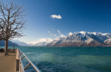
The Rhône valley on the right and the east part of the Chablais Alps on the left from across Lake Geneva
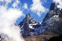
Summits of the Dents du Midi
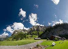
Above Champéry

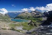
Tour Sallière
The main peaks of the Chablais Alps are:
| Peak | Elevation (m/ft) | |
|---|---|---|
| Dents du Midi | 3,257 | 10,686 |
| Tour Sallière | 3,220 | 10,564 |
| Mont Ruan | 3,053 | 10,016 |
| Aiguilles Rouges | 2,965 | 12,943 |
| Le Luisin | 2,786 | 9,140 |
| Dents Blanches | 2,759 | 9,052 |
| Fontanabran | 2,703 | 8,868 |
| Cornettes de Bise | 2,432 | 7,979 |
| Les Jumelles | 2,215 | 7,267 |
| Le Grammont | 2,172 | 7,126 |
| Pointe de l'Au | 2,152 | 7,060 |
| Pointe de Bellevue | 2,042 | 6,699 |
| Le Môle | 1,863 | 6,112 |
See also
References
This article is issued from Wikipedia - version of the 1/23/2016. The text is available under the Creative Commons Attribution/Share Alike but additional terms may apply for the media files.