Dents du Midi
| Dents du Midi | |
|---|---|
| Haute Cime | |
|
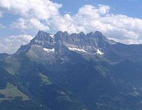
Dents du Midi seen from Pointe Bellevue. From left to right : La Cime de l'Est, La Forteresse, La Cathédrale, l'Éperon, Dent Jaune, Les Doigts and the highest point : La Haute Cime | |
| Highest point | |
| Elevation | 3,257 m (10,686 ft) |
| Prominence | 1,796 m (5,892 ft) [1] |
| Isolation | 19.0 km (11.8 mi) [2] |
| Parent peak | Mont Blanc |
| Listing | Ultra |
| Coordinates | 46°09′39.6″N 6°55′24.3″E / 46.161000°N 6.923417°ECoordinates: 46°09′39.6″N 6°55′24.3″E / 46.161000°N 6.923417°E |
| Geography | |
 Dents du Midi Location in Switzerland | |
| Location | Valais, Switzerland |
| Parent range | Chablais Alps |
| Geology | |
| Mountain type | limestone |
| Climbing | |
| First ascent | 1784 |
The Dents du Midi (French: "teeth of noon")[3] are a multi-summited mountain situated in the Chablais Alps in the Swiss canton of Valais. They are composed of seven distinct summits and reach a height of 3257 metres (10,686 feet). Dominating the Val-d'Illiez and the Rhône Valley, to the south it faces the Lac de Salanfe, an artificial reservoir. Geologically it makes up a part of the massif Haut-Giffre.
The seven peaks
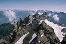
The "Dents", or "Teeth" are, from east to west:
- La Cime de l'Est (3178 metres, 10,426.51 feet)
- La Forteresse (3164 m, 10,380.58 ft)
- La Cathédrale (3160 m, 10,367.45 ft)
- L'Éperon (3114 m, 10,216.54 ft)
- Dent Jaune (3186 m, 10,452.76 ft)
- Les Doigts (3205 m, 10,515.09 ft and 3210 m, 10,531.50 ft) or Doigts de Salanfe
- La Haute Cime (3257 m, 10,685.70 ft)
Rockfalls
On the morning of October 30, 2006, a mass of 1,000,000 m³ (35,300,000 ft³) of rocks detached themselves from the side of the Haute Cime and fell down the side to an altitude of about 3,000 m (9,800 ft) The event did not pose any danger for the nearby town of Val-d'Illiez but roads and footpaths were closed as a security measure. According to the geologists of the canton, the landslide was caused by thawing, assisted by the hot summers of the preceding years.[4]
Shortly after midday on Friday 17 August 2012, another significant rockfall occurred below the Cathédrale, amounting to at least 100,000m³ of rock. Twelve hikers were rescued by helicopter, All were unscathed, as was a flock of sheep grazing nearby. Again, the fall was put down to exceptional heat locally.[5]
Less serious falls continued over the next few days and hiking trails remained closed.[6]
Origin of the name
The name "Dents du Midi" is of relatively recent origin. The native inhabitants originally called them the "Teeth of Tsallen". The present Haute Cime was then called Dent du Midi, and it eventually gave its name to the entire mountain.[7]
Each peak, or "tooth", has had several names over the centuries:
- La Cime de l'Est (Summit of the East) was called Mont de Novierre before approximately the seventeenth century, then Mont Saint Michel after the landslides of 1635 and 1636, and finally Dent Noire (Black Tooth) till the 19th century.
- Dent Jaune (The Yellow Tooth) was called the Dent Rouge (Red Tooth) until 1879.
- Les Doigts (The Fingers) were called Le Doigt de Champéry (The Finger of Champéry, 1882) then Le Doigt de Salanfe (The Finger of Salanfe, 1886) before finally just Les Doigts.
- La Haute Cime (The High Summit) also had several names: Dent de l’Ouest (Tooth of the West, 1784), Dent du Midi (Tooth of the South), Dent de Tsallen (Tooth of Tsallen), and Dent de Challent (Tooth of Challent).
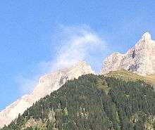
L’Éperon
Several ruptures in the massif have changed the form of the peaks so much that the names adapted themselves according to the geological evolution. L’Éperon (The Spur), for example, no longer has two summits, since a landslide in the Middle Ages significantly changed this peak.
First ascents
| Name of peak | Date of first ascent[8] | Climber(s) |
|---|---|---|
| Cime de l'Est | 16 August 1842 | Nicolaz Delez |
| Forteresse | 7 June 1870 | E. Javelle and J. Oberhauser |
| La Cathédrale | 1890 | Nicolas Delez |
| L'Éperon | ? | ? |
| La Dent Jaune | 24 August 1879 | ? |
| Les Doigts | ? | ? |
| La Haute Cime | 1784[9] | Jean-Maurice Clément |
See also
.jpg)
- List of mountains of Valais
- List of mountains of Switzerland
- List of most isolated mountains of Switzerland
References
- ↑ Retrieved from the Swisstopo topographic maps. The key col is the Col des Montets (1,461 m).
- ↑ Retrieved from Google Earth. The nearest point of higher elevation is north of the Aiguille du Génépi (Mont Blanc massif).
- ↑ "Names - Swiss Mountains". Swissinfo. Swiss Confederation. Retrieved 2015-01-28.
- ↑ Tsr.ch
- ↑ Nouvelliste.ch
- ↑ Nouvelliste.ch
- ↑ Monvillage.ch
- ↑ Monvillage.ch
- ↑ Valdilliez.ecolevs.ch
External links
| Wikimedia Commons has media related to Dents du Midi. |