Chacao, Venezuela
Coordinates: 10°29′N 066°50′W / 10.483°N 66.833°W
| Municipio Chacao (Chacao Municipality) | |||
|---|---|---|---|
|
San José de Chacao Church | |||
| |||
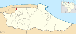 Chacao in Miranda State | |||
| Coordinates: 10°29′47″N 066°50′56″W / 10.49639°N 66.84889°W | |||
| Country | Venezuela | ||
| State | Miranda | ||
| Seat | N/A | ||
| Founded | September 27, 1769 | ||
| Incorporated | 1991 | ||
| Government | |||
| • Mayor | Ramón Muchacho | ||
| Area | |||
| • Total | 12 km2 (5 sq mi) | ||
| Population (2001) | |||
| • Total | 64,629 | ||
| • Density | 5,385.8/km2 (13,949/sq mi) | ||
| Time zone | VST (UTC-4:30) | ||
| • Summer (DST) | not observed (UTC-4:30) | ||
| Website | http://www.chacao.gov.ve/ | ||

Chacao is one of the five political and administrative subdivisions of the city of Caracas, Venezuela. The other four are Baruta, El Hatillo, Libertador and Sucre. This legal entity is known as the Caracas Metropolitan District. Chacao is also one of the 21 municipalities that make up the State of Miranda, Venezuela.
Geography
Chacao occupies the mid-eastern portion of the Caracas Valley, north of the Guaire River, bordering the other urban municipalities to the east, south and west, and the Avila National Park to the north.
Economy

Chacao is, along with Baruta and the Salias, one of the communities with least poverty in Venezuela with a poverty rate of only 4.67% according to the 2011 census. It is home to some of the city's major financial and commercial centers, such as the Center City Commercial Tamanaco (CCCT), Sambil Shopping Mall, Centro Lido, San Ignacio and soon El Recreo Mall La Castellana, as well as the branches of the majors local banks, and foreign institutions, stock exchanges, the most luxurious hotels in the city, and the mansions of recognized personalities in the political and economic sphere.
Many of the city's shopping malls are located within Chacao's borders. The township also controls the most transited pedestrian access to the Avila National Park (Sabas Nieves), a popular destination for caraqueños. Other attractions include a restaurant district in the neighborhoods of La Castellana, Altamira and Los Palos Grandes, a Center for Performing Arts (CELARG) and the Chacao Culture Center, a public space dedicated to concerts, art expositions and other cultural activities. Parque del Este, the biggest urban park in Caracas, although largely in neighboring Sucre territory, has one of its main entrances in Chacao, making it a popular recreational and exercise area for the inhabitants of Los Palos Grandes and other Chacao neighborhoods.
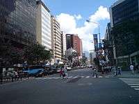
The municipality has become a financial center after many of the country's banks moved their headquarters to the formerly residential neighborhood of El Rosal. The main street artery, Francisco de Miranda avenue and its vicinity, rivals Caracas' old downtown in office space availability, and is preferred by foreign companies with established offices in the country. Some signature office buildings include Parque Cristal, Letonia Center, HP Tower, Atlantic Building, La Castellana Center, Multicentro Empresarial del Este, Centro Lido, Centro San Ignacio, KPMG Tower, Forum Tower, Shell Tower, and other important architectural landmarks. Several other office buildings are occupied by government-controlled entities such as the Pequiven and Banco del Tesoro towers.
The traditional Venezuelan private sector has given way to new short-term businesses and franchises that bloom around the city thanks in part to soaring oil prices. Chacao is again an important player in this money wave craze, with commercial and residential real estate prices among the highest in the nation. The residential neighborhood of Campo Alegre has on average the highest priced real estate in the country.
Demographics


The Cathedral and Bolivar Square area, known as Pueblo de Chacao was home to Spanish, Italian and Portuguese immigrant waves, and today represents a middle class stronghold in the municipality. Small pockets of poverty, known as barrios, are also present, some of the best known are Pajaritos and El Pedregal which are surrounded by luxury condos and opulent houses.
Law and government
Former mayor Leopoldo López Mendoza, elected in 2000 and re-elected for the 2004-2008 term, has played a prominent role in anti-Chávez politics over the past eight years. On November 23, 2008, Emilio Graterón was elected mayor with 47,54% of vote.[1] Chacao has represented a stronghold for the Venezuelan opposition. Anti-Chavez votes have steadily represented between 85 and 95% of the total votes in the borough, throughout the length of Chavez's administration.
The current Ministry of Aquatic and Air Transport has its headquarters in the Torre Pequiven.[2] The Ministry of Transport and Communications previously had its headquarters in the Torre MTC in Chacao.[3] The Junta Investigadora de Accidentes de Aviación Civil, the Venezuelan aircraft accident investigation agency, had its headquqarters in Chacao.[4]
Mayors
| Period | Mayor | % of votes | Political Party | Notes |
|---|---|---|---|---|
| 1992-1995 | Irene Sáez | Copei / Democratic Action | First Mayor | |
| 1995-1998 | Irene Sáez | Copei / Democratic Action | Re elected | |
| 1998-2000 | Cornelio Popesco | Democratic Action | ||
| 2000-2004 | Leopoldo López | 51 | Justice First | |
| 2004-2008 | Leopoldo López | 79,56[5] | Justice First / A New Era | Re elected |
| 2008-2013 | Emilio Graterón | 47,54[6] | Popular Will | |
| 2013-2017 | Ramón Muchacho | 84,63 | Justice First |
History

In Cumanagoto language Chakau (Chacao) means sand, the municipality was named after the Indian Cacique Chacao, who died defending his territory in 1567, the year when the city of Santiago de León de Caracas was finally established after more than three decades of unsuccessful attempts by the Spanish. The chosen location for Caracas Plaza Mayor and Cathedral was on the west side of the valley, making the fertile lands of Chacao (on the mid-east side) an ideal location for agricultural crops and establishment of haciendas. Spanish conquistador Diego de Losada, founder of the city of Caracas, included these lands in his jurisdiction.
The township of Chacao was founded by an immigration wave of the San Bernabé earthquake victims on June 11, 1641. It was officially made a Catholic parish with the foundation of San José de Chacao church.
After repeated epidemics and calamities affected Caracas, the Town Hall and the Governor and Commander in chief of the Province, Jose Solano y Bote, in 1764 thought about transferring the entire city to this location, an idea that was rejected by Caracas Bishop Mauro Tovar.
On April 15, 1769, the residents of Chacao asked for the creation of an independent ecclesiastical parish, Lieutenant Francisco Palacios y Sojo, made the request, after evaluating the economic conditions, the separation of Chacao from the Parish of La Candelaria was granted on September 27, 1769.
See also
References
- ↑ Consejo Nacional Electoral (2008-11-24). "Divulgación Elecciones Regionales 2008". Retrieved 2008-11-25. (Spanish)
- ↑ "Home." (Archive) Ministry of Aquatic and Air Transport. Retrieved on December 7, 2013. "Av. Francisco de Miranda Torre PEQUIVEN piso 12, Chacao, Caracas - Venezuela Codigo Postal 1010"
- ↑ "Inicio." Ministry of Transport and Communications. Retrieved on May 6, 2011. "Torre MTC, Municipio Chacao. Distrito Capital. Tlf: (0212) 201 50 42 RIF: G-20009480-0"
- ↑ "Contacto de la JIAAC." Junta Investigadora de Accidentes de Aviación Civil. Retrieved on May 6, 2011. "Dirección: Av. Francisco de Miranda, Edificio Sede Piso 20, Junta Investigadora de Accidentes de Aviación Civil, Chacao, Caracas 1010, Distrito capital – Venezuela"
- ↑ http://www.cne.gob.ve/regionales2004/
- ↑ http://www.cne.gob.ve/divulgacion_regionales_2008/index.php?e=13&m=18&p=00&c=00&t=00&ca=00&v=02
External links
| Wikimedia Commons has media related to Chacao Municipality. |
Caracas Divisions | ||
|---|---|---|
| Northwest |
| |
| Center |
| |
| Southwest | ||
| Centereastern |
| |
| South |
| |
| Eastern |
| |
| Southeastern |
| |