Chandragiri
| Chandragiri చంద్రగిరి | |
|---|---|
| Village | |
|
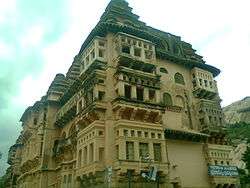
Raja Mahal, Chandragiri | |
 Chandragiri  Chandragiri Location in Andhra Pradesh, India | |
| Coordinates: 13°35′00″N 79°19′00″E / 13.5833°N 79.3167°ECoordinates: 13°35′00″N 79°19′00″E / 13.5833°N 79.3167°E | |
| Country | India |
| State | Andhra Pradesh |
| Mandal | Chandragiri |
| Government | |
| • Member of Legislative Assembly | CheviReddy Bhaskar Reddy |
| Area[1] | |
| • Total | 19.56 km2 (7.55 sq mi) |
| Population (2011)[1] | |
| • Total | 20,299 |
| • Density | 1,000/km2 (2,700/sq mi) |
| Languages | |
| • Official | Telugu |
| Time zone | IST (UTC+5:30) |
| PIN | 517101 |
| Telephone code | +91–877 |

Chandragiri is a village in Chittoor district of the Indian state of Andhra Pradesh. It is the mandal headquarters of Chandragiri mandal in Tirupati revenue division.[1][2] It also falls in the jurisdictional limit of Tirupati Urban Development Authority.[3]
History
Chandragiri fort
Chandragiri is now famous for the historical fort, built in the 11th century, and the Raja Mahal (Palace) within it. The fort encircles eight ruined temples of saivite and vaishnavite pantheons, Raja Mahal, Rani Mahal and other ruined structures. The Raja Mahal Palace is now an archaeological museum. The palace is an example of Indo-Sarcen architecture of Vijayanagar period. The palace was constructed using stone, brick, lime mortar and devoid of timber.[4] The crowning towers represents the Hindu architectural elements.
Chandragiri was under the rule of Yadava Naidus for about three centuries and came into control of Vijayanagar rulers in 1367. It came into prominence during Saluva Narasimha Rayalu. Chandragiri was the 4th capital of Vijayanagar Empire. Rayas shifted their capital to here when Golconda sultans attacked Penukonda. In 1646, the fort was annexed to the Golkonda territory and subsequently came under Mysore rule. It went into oblivion from 1792 onward.[4]
References
| Wikimedia Commons has media related to Chandragiri. |
- 1 2 3 "District Census Handbook - Chittoor" (PDF). Census of India. p. 19,280. Retrieved 29 November 2015.
- ↑ "Chittoor District Mandals" (PDF). Census of India. pp. 460, 512. Retrieved 19 June 2015.
- ↑ "TUDA Right to Information Act, 2005". TUDA. Retrieved 19 June 2015.
- 1 2 Archaeological Survey of India (2008). "Raja and Rani Mahal, Chandragiri Fort; Ticketed Monuments - Andhra Pradesh". Archaeological Survey of India. Archived from the original (asp) on 2008-09-30. Retrieved 2008-09-30.