Charles River Speedway


The Charles River Speedway was a former bicycle and harness racing track located in Allston, Massachusetts.
History
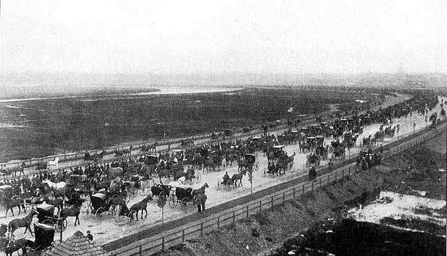
The speedway itself was constructed in 1899 along the Charles River. It began around Market and Arsenal Street and extended all the way to the Harvard Stadium. It was designed by a firm co-founded by Frederick Law Olmsted.[1][2]
One of the functions of the speedway was to move the racing of horses and other pleasurable activities off of Brighton Road (now Commonwealth Avenue) west of Kenmore Square and Beacon Street in Brookline. As traffic on the roads increased, it became necessary to build the speedway.[1]
Amenities to the facility included a bicycle racing course, a 1 mile (1.6 km) long race course, a 1.75 miles (2.82 km) driveway, and use of the original Soldiers Field Road. At some point, the track was shortened to an oval around where the center of the original track now stands and use ended in the 1960s.[1]
One of the bigger events at the speedway occurred on October 13, 1930 when a new course speed record was set. After seven hours of competition, which was viewed by thousands of spectators, a time of 2:05.5 was set for the 1 mile (1.6 km) race. The horse team was driven by a Mr. Grattan, the pacer of Mrs. Charles F. Adams.[3]
Today, only the superintendent's building (Charles River Reservation (Speedway)-Upper Basin Headquarters) is left. It was listed on the National Register of Historic Places. The building itself was even listed on the National Register of Historic Places featured properties and districts list on July 30, 2010. Additionally, it was listed on July 19 of that year. At some point, and by 1941, the building itself was turned into a police substation for the [Metropolitan Police Department " The Mets"].
References
- 1 2 3 Brighton Allston Historical Society. "Allston Trotting Parks". Retrieved 1 June 2011.
- ↑ Marchione, William P. (2007). Allston-Brighton in Transition: From Cattle Town to Streetcar Suburb. Charleston, SC: The History Press. p. 140.
- ↑ Ryan, Andrew. "In a stealth race against time". The Boston Globe. Retrieved 2 June 2011.
External links
Sports venues in the Greater Boston area | ||
|---|---|---|
| Active |   | |
| Defunct | ||
| Never built | ||
Coordinates: 42°21′58.22″N 71°8′3.82″W / 42.3661722°N 71.1343944°W