Charleston Municipal Airport
| Charleston Municipal Airport | |||||||||||
|---|---|---|---|---|---|---|---|---|---|---|---|
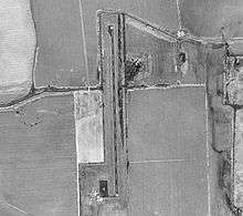 USGS 1996 orthophoto | |||||||||||
| IATA: none – ICAO: none – FAA LID: 09M | |||||||||||
| Summary | |||||||||||
| Airport type | Public | ||||||||||
| Owner | City of Charleston | ||||||||||
| Serves | Charleston, Mississippi | ||||||||||
| Elevation AMSL | 175 ft / 53 m | ||||||||||
| Coordinates | 33°59′29″N 090°04′43″W / 33.99139°N 90.07861°W | ||||||||||
| Runways | |||||||||||
| |||||||||||
| Statistics (2012) | |||||||||||
| |||||||||||
Charleston Municipal Airport (FAA LID: 09M) is a city owned, public use airport located two nautical miles (4 km) south of the central business district of Charleston, a city in Tallahatchie County, Mississippi, United States.[1] It is included in the National Plan of Integrated Airport Systems for 2011–2015, which categorized it as a general aviation facility.[2]
Facilities and aircraft
Charleston Municipal Airport covers an area of 47 acres (19 ha) at an elevation of 175 feet (53 m) above mean sea level. It has one runway designated 18/36 with an asphalt surface measuring 3,000 by 50 feet (914 x 15 m). For the 12-month period ending January 4, 2012, the airport had 5,700 general aviation aircraft operations, an average of 15 per day.[1]
See also
References
- 1 2 3 FAA Airport Master Record for 09M (Form 5010 PDF). Federal Aviation Administration. Effective April 5, 2012.
- ↑ "2011–2015 NPIAS Report, Appendix A" (PDF). National Plan of Integrated Airport Systems. Federal Aviation Administration. October 4, 2010. Archived from the original (PDF, 2.03 MB) on 2012-09-27.
External links
- Aerial image as of February 1996 from USGS The National Map
- Resources for this airport:
- FAA airport information for 09M
- AirNav airport information for 09M
- FlightAware airport information and live flight tracker
- SkyVector aeronautical chart for 09M
This article is issued from Wikipedia - version of the 11/20/2016. The text is available under the Creative Commons Attribution/Share Alike but additional terms may apply for the media files.