Charlton Marshall
| Charlton Marshall | |
 Charlton Marshall |
|
 Charlton Marshall |
|
| Population | 1,156 |
|---|---|
| OS grid reference | ST903038 |
| District | North Dorset |
| Shire county | Dorset |
| Region | South West |
| Country | England |
| Sovereign state | United Kingdom |
| Post town | BLANDFORD FORUM |
| Postcode district | DT11 |
| Police | Dorset |
| Fire | Dorset and Wiltshire |
| Ambulance | South Western |
| EU Parliament | South West England |
| UK Parliament | North Dorset |
Coordinates: 50°50′04″N 2°08′27″W / 50.8345°N 2.1408°W
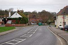
Charlton Marshall is a village and civil parish in the English county of Dorset. It lies within the North Dorset administrative district, on the A350 road 2 miles (3.2 km) south of the market town of Blandford Forum. It is sited on a river terrace above the floodplain of the River Stour, with most of the land in the parish stretching south-west over chalk hills.[1] In the 2011 census the number of dwellings recorded within the parish was 513[2] and the population was 1,156.[3]
Within the parish boundary is evidence of the sites of Anglo-Saxon burial mounds, and human habitation in the parish can be dated back at least a thousand years.[4] Next to the river were three earlier settlements, which influenced the elongated layout of the current village.[1] The parish church was rebuilt in 1713 and restored in 1895,[5] although the tower dates from the 15th century.[6] Charlton Marshall Halt railway station was once a halt on the Somerset and Dorset Joint Railway.
Within the last half century Charlton Marshall has grown considerably, and there are now more than five times as many homes in the village as there were in the middle of the 19th century.[4] A proposal to jointly bypass Charlton Marshall and neighbouring Spetisbury has never been realised.[7]
Charlton Marshall civil parish is in Riversdale electoral ward, which also includes Spetisbury civil parish to the south. The total ward population in the 2011 census was 1,711.[8]
References
- 1 2 "'Charlton Marshall' An Inventory of the Historical Monuments in Dorset, Volume 3: Central (1970) pp56-59". University of London & History of Parliament Trust (British History Online). 2013. Retrieved 29 November 2013.
- ↑ "Neighbourhood Statistics. Area: Charlton Marshall (Parish). Dwellings, Household Spaces and Accommodation Type, 2011 (KS401EW)". Retrieved 30 November 2013.
- ↑ "Neighbourhood Statistics. Area: Charlton Marshall (Parish). Key figures for 2011 Census: Key Statistics". Office for National Statistics. Retrieved 30 November 2013.
- 1 2 "Charlton Marshall Parish plan". Dorset County Council. Retrieved 12 February 2013.
- ↑ "Charlton Marshall". Dorset OPC Project. 2013. Retrieved 29 November 2013.
- ↑ North Dorset District Council, District Official Guide, Home Publishing Co. Ltd., c.1983, p31
- ↑ Hugh Starkey (February 2013). "Down my way: Charlton Marshall Halt". Dorset Life Magazine. Retrieved 29 June 2014.
- ↑ "Riversdale". ukcensusdata.com. Retrieved 28 February 2015.
External links
![]() Media related to Charlton Marshall at Wikimedia Commons
Media related to Charlton Marshall at Wikimedia Commons
