DT postcode area
Postcode district boundaries: Bing / Google
| Dorchester postcode area | |
|---|---|
 DT | |
| Postcode area | DT |
| Postcode area name | Dorchester |
| Post towns | 9 |
| Postcode districts | 11 |
| Postcode sectors | 39 |
| Postcodes (live) | 7,659 |
| Postcodes (total) | 9,322 |
| Statistics as at February 2012[1] | |
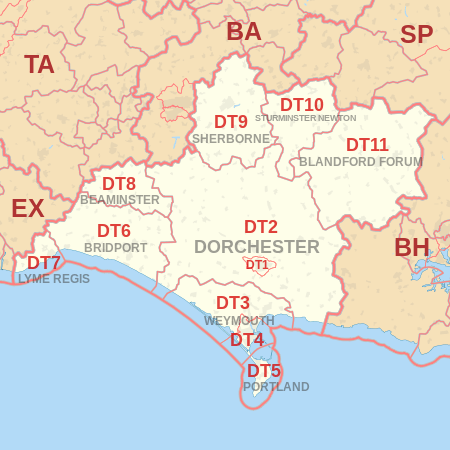
The DT postcode area, also known as the Dorchester postcode area,[2] is a group of eleven postcode districts in England, which are subdivisions of nine post towns. These postcode districts cover much of Dorset, including Dorchester, Weymouth, Beaminster, Blandford Forum, Bridport, Lyme Regis, Portland, Sherborne and Sturminster Newton, plus very small parts of Devon and Somerset.
Coverage
The approximate coverage of the postcode districts:
| Postcode district | Post town | Coverage | Local authority area |
|---|---|---|---|
| DT1 | DORCHESTER | West Dorset | |
| DT2 | DORCHESTER | West Dorset | |
| DT3 | WEYMOUTH | Chickerell, Broadwey, Radipole, Osmington, Preston, Littlemoor, Portesham, Abbotsbury, Langton Herring | Weymouth and Portland, West Dorset |
| DT4 | WEYMOUTH | Weymouth town centre, Melcombe Regis, Wyke Regis | Weymouth and Portland |
| DT5 | PORTLAND | Fortuneswell, Easton, Southwell, Weston, The Grove | Weymouth and Portland |
| DT6 | BRIDPORT | West Dorset | |
| DT7 | LYME REGIS | Lyme Regis, Uplyme, Rousdon | West Dorset, East Devon |
| DT8 | BEAMINSTER | West Dorset | |
| DT9 | SHERBORNE | West Dorset, South Somerset | |
| DT10 | STURMINSTER NEWTON | North Dorset | |
| DT11 | BLANDFORD FORUM | North Dorset |
Map
See also
References
- ↑ "ONS Postcode Directory Version Notes" (ZIP). National Statistics Postcode Products. Office for National Statistics. February 2012. Table 2. Retrieved 21 April 2012. Coordinates from mean of unit postcode points, "Code-Point Open". OS OpenData. Ordnance Survey. February 2012. Retrieved 21 April 2012.
- ↑ Royal Mail, Address Management Guide, (2004)
External links
- Royal Mail's Postcode Address File
- A quick introduction to Royal Mail's Postcode Address File (PAF)
- Postcode finder
This article is issued from Wikipedia - version of the 4/12/2016. The text is available under the Creative Commons Attribution/Share Alike but additional terms may apply for the media files.