Chianan Irrigation
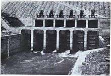

Chianan Irrigation (Chinese and Japanese: 嘉南大圳; pinyin: Jianán Dàzùn; rōmaji: Kanan Taishū; literally: "Chianan Great Ditch"), also known as the Kanan Irrigation System,[1] was built for promoting the agricultural productions of Chianan Plain of Taiwan. The name "chia-nan" was derived from two place names among its surrounding area called Chiayi and Tainan. Although it includes some assistant facilities, such as the Wusanto Reservoir, the term "Chianan Canal", in a narrow sense, would only means the canals of this system.
The main designer of the Chianan Canal is Yoichi Hatta, a civil engineer of the Japanese government. Its main streams pass through today's Tainan, Chiayi and Yunlin, formerly parts of Tainan Prefecture. The architectural work of canal was launched in 1920 and completed in 1930, during Japanese rule. The canal improved the plantable area for rice from 5000 to 150,000 hectares, and made the rice crops in its irrigated area can harvest three times annually.[2]