Chirac, Lozère
| Chirac | ||
|---|---|---|
|
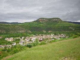
A view of Chirac and St-Bonnet | ||
| ||
 Chirac | ||
|
Location within Occitanie region  Chirac | ||
| Coordinates: 44°31′29″N 3°15′58″E / 44.5247°N 3.2661°ECoordinates: 44°31′29″N 3°15′58″E / 44.5247°N 3.2661°E | ||
| Country | France | |
| Region | Occitanie | |
| Department | Lozère | |
| Arrondissement | Mende | |
| Canton | Chirac | |
| Intercommunality | Gévaudan | |
| Government | ||
| • Mayor (2008–2014) | Henri Boyer | |
| Area1 | 33.79 km2 (13.05 sq mi) | |
| Population (1999)2 | 1,006 | |
| • Density | 30/km2 (77/sq mi) | |
| Time zone | CET (UTC+1) | |
| • Summer (DST) | CEST (UTC+2) | |
| INSEE/Postal code | 48049 / 48100 | |
| Elevation |
605–1,254 m (1,985–4,114 ft) (avg. 640 m or 2,100 ft) | |
|
1 French Land Register data, which excludes lakes, ponds, glaciers > 1 km² (0.386 sq mi or 247 acres) and river estuaries. 2 Population without double counting: residents of multiple communes (e.g., students and military personnel) only counted once. | ||

Chirac is a former commune in the Lozère département in southern France. On 1 January 2016, it was merged into the new commune of Bourgs-sur-Colagne.[1]
Geography
Situated on the banks of the Colagne river in the heart of the Massif central. The D809 road passes through the village.
Population
| Year | 1962 | 1968 | 1975 | 1982 | 1990 | 1999 |
|---|---|---|---|---|---|---|
| Population | 801 | 789 | 689 | 894 | 983 | 1006 |
| From the year 1962 on: No double counting—residents of multiple communes (e.g. students and military personnel) are counted only once. | ||||||
Places and monuments
- The Fare dolmen
- The twelfth century Romanesque church.
- The chapel of Saint-Jean-Baptiste.
- The family chapels of the Chazette and the Volmanières
- The English cross: The English, who ravaged the country in the 14th century, were soundly beaten in a battle on the heights of the village. This place carries today the name of Cemetery of the English or Cross of the English. A cross, on which there is an inscription "CH des M" and "1701 - 1922", marks the site of the battle. During the construction of the A75 autoroute, the cross was renovated and moved a few metres from its original position.
- The bridge over the Colagne river.
Activities
As in the majority of the towns of Lozère, the principal activity is farming, although service industry sectors have started to play a larger part in the region.
- Farming is essentially sheep and cattle. The size of the upland meadows allows the farmers to have comparatively large flocks.
Notable people
- Colonel Marceau Crespin (1915–1988)
- Nicolaï Greschny (1912–1985), artist
See also
References
- ↑ Arrêté préfectoral 15 December 2015
External links
| Wikimedia Commons has media related to Chirac (Lozère). |
This article is issued from Wikipedia - version of the 3/4/2016. The text is available under the Creative Commons Attribution/Share Alike but additional terms may apply for the media files.