Arrondissement of Mende
| Mende | |
|---|---|
| Arrondissement of France | |
 | |
| Country | France |
| Region | Occitanie |
| Department | Lozère |
| Communes | 132 |
| Prefecture | Mende |
| Area¹ | |
| • Total | 3,479.4 km2 (1,343.4 sq mi) |
| Population (2013) | |
| • Total | 63,277 |
| • Density | 18/km2 (47/sq mi) |
| ¹ French Land Register data, which exclude lakes, ponds, and glaciers larger than 1 km² as well as the estuaries of rivers. | |
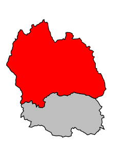
The arrondissement of Mende is an arrondissement of France in the Lozère department in the Occitanie région. Its INSEE code is 482 and its capital city, and prefecture of the department, is Mende.
It is the larger arrondissement of the department, with an area of 3,479.4 km2 (1,343.4 sq mi).[1] It has a population of 63,613 inhabitants and a density of 18.3 inhabitants/km².[2]
The only important city is Mende with 11,908 people living there in 2012. Other towns are Marvejols (4,950) and Saint-Chély-d'Apcher (4,187).[2]
History
When the Lozère department was created on 17 February 1800, the arrondissement of Mende was part of that original department.[3]
Geography
The arrondissement covers the northern part of the department and is bordered to the north by the Auvergne region (the Cantal department to the northwest and the Haute-Loire department to the northeast), to the east by the Ardeche department (Rhône-Alpes region), to the south by the arrondissement of Florac and to the west by the Aveyron department (Midi-Pyrénées region).
Composition
Cantons
The cantons of the arrondissement of Mende are:
- Aumont-Aubrac (4801)
- La Canourgue (4802)
- Chirac (4803)
- Grandrieu (4806)
- Langogne (4807)
- Marvejols (4808)
- Mende-1 (4809)
- Mende-2 (4810)
- Saint-Alban-sur-Limagnole (4811)
- Saint-Chély-d'Apcher (4812)
- Saint-Étienne-du-Valdonnez (4813)
Communes
The arrondissement of Mende has 132 communes; they are (with their INSEE codes):
- Albaret-le-Comtal (48001)
- Albaret-Sainte-Marie (48002)
- Allenc (48003)
- Altier (48004)
- Antrenas (48005)
- Arzenc-d'Apcher (48007)
- Arzenc-de-Randon (48008)
- Aumont-Aubrac (48009)
- Auroux (48010)
- Badaroux (48013)
- Bagnols-les-Bains (48014)
- Balsièges (48016)
- Banassac-Canilhac (48017)
- Barjac (48018)
- La Bastide-Puylaurent (48021)
- Belvezet (48023)
- Les Bessons (48025)
- Blavignac (48026)
- Le Bleymard (48027)
- Le Born (48029)
- Bourgs-sur-Colagne (48099)
- Brenoux (48030)
- Brion (48031)
- Le Buisson (48032)
- La Canourgue (48034)
- Chadenet (48037)
- Chambon-le-Château (48038)
- Chanac (48039)
- Chasseradès (48040)
- Chastanier (48041)
- Chastel-Nouvel (48042)
- Châteauneuf-de-Randon (48043)
- Chauchailles (48044)
- Chaudeyrac (48045)
- Chaulhac (48046)
- La Chaze-de-Peyre (48047)
- Cheylard-l'Évêque (48048)
- Cubières (48053)
- Cubiérettes (48054)
- Cultures (48055)
- Esclanèdes (48056)
- Estables (48057)
- La Fage-Montivernoux (48058)
- La Fage-Saint-Julien (48059)
- Fau-de-Peyre (48060)
- Fontans (48063)
- Fournels (48064)
- Gabrias (48068)
- Grandrieu (48070)
- Grandvals (48071)
- Grèzes (48072)
- Les Hermaux (48073)
- Javols (48076)
- Julianges (48077)
- Lachamp (48078)
- Lajo (48079)
- Langogne (48080)
- Lanuéjols (48081)
- Laubert (48082)
- Les Laubies (48083)
- Laval-Atger (48084)
- Laval-du-Tarn (48085)
- Luc (48086)
- Malbouzon (48087)
- Le Malzieu-Forain (48089)
- Le Malzieu-Ville (48090)
- Marchastel (48091)
- Marvejols (48092)
- Mas-d'Orcières (48093)
- Mende (48095)
- Montbel (48100)
- Montrodat (48103)
- Les Monts-Verts (48012)
- Nasbinals (48104)
- Naussac-Fontanes (48105)
- Noalhac (48106)
- Palhers (48107)
- La Panouse (48108)
- Paulhac-en-Margeride (48110)
- Pelouse (48111)
- Pied-de-Borne (48015)
- Pierrefiche (48112)
- Pourcharesses (48117)
- Prévenchères (48119)
- Prinsuéjols (48120)
- Prunières (48121)
- Recoules-d'Aubrac (48123)
- Recoules-de-Fumas (48124)
- Ribennes (48126)
- Rieutort-de-Randon (48127)
- Rimeize (48128)
- Rocles (48129)
- Saint-Alban-sur-Limagnole (48132)
- Saint-Amans (48133)
- Saint-André-Capcèze (48135)
- Saint-Bauzile (48137)
- Saint-Bonnet-de-Chirac (48138)
- Saint-Bonnet-de-Montauroux (48139)
- Saint-Chély-d'Apcher (48140)
- Saint-Denis-en-Margeride (48145)
- Sainte-Colombe-de-Peyre (48142)
- Sainte-Eulalie (48149)
- Sainte-Hélène (48157)
- Saint-Étienne-du-Valdonnez (48147)
- Saint-Flour-de-Mercoire (48150)
- Saint-Frézal-d'Albuges (48151)
- Saint-Gal (48153)
- Saint-Germain-du-Teil (48156)
- Saint-Jean-la-Fouillouse (48160)
- Saint-Juéry (48161)
- Saint-Julien-du-Tournel (48164)
- Saint-Laurent-de-Muret (48165)
- Saint-Laurent-de-Veyrès (48167)
- Saint-Léger-de-Peyre (48168)
- Saint-Léger-du-Malzieu (48169)
- Saint-Paul-le-Froid (48174)
- Saint-Pierre-de-Nogaret (48175)
- Saint-Pierre-le-Vieux (48177)
- Saint-Privat-du-Fau (48179)
- Saint-Saturnin (48181)
- Saint-Sauveur-de-Ginestoux (48182)
- Saint-Sauveur-de-Peyre (48183)
- Saint-Symphorien (48184)
- Les Salces (48187)
- Les Salelles (48185)
- Serverette (48188)
- Servières (48189)
- Termes (48190)
- La Tieule (48191)
- Trélans (48192)
- La Villedieu (48197)
- Villefort (48198)
References
- ↑ "Arrondissement de Mende (482) - Résumé statistique". Publications et statistiques pour la France ou les régions (in French). Institut national de la statistique et des études économiques - INSEE. Retrieved 19 August 2015.
- 1 2 "Populations lègales 2012 - 48-Lozère". Populations légales 2012 des départements et des collectivités d'outre-mer (in French). Institut national de la statistique et des études économiques - INSEE. Retrieved 19 August 2015.
- ↑ "Historique de la Lozère". Le SPLAF (in French). Retrieved 19 August 2015.
Coordinates: 44°31′00″N 3°30′07″E / 44.51667°N 3.50194°E