Chiribiquete National Park
| Chiribiquete National Park PNN Serranía de Chiribiquete | |
|---|---|
|
IUCN category II (national park) | |
|
Tepui in the Park | |
| Nearest city | San José del Guaviare |
| Area | 12,800 square kilometres (4,900 sq mi) |
| Established | 1989 |
| Parques nacionales | |
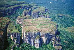
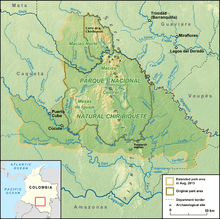
Chiribiquete National Natural Park (Spanish: Parque Nacional Natural Sierra de Chiribiquete) is the largest national park in Colombia and was formed in 1989. This park occupies 12,800 square kilometres (4,900 sq mi) and includes the Serranía de Chiribiquete mountains and the surrounding lowlands which is covered by tropical moist forest, savannas and rivers.[1]
In August 2013, Chiribiquete National Natural Park was expanded from the previous 1.2 million hectares to 3 million hectares. The announcement was made a few days after Ecuador decided to explore for oil within its protected natural parks in the Amazon region.
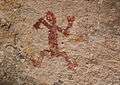
In 2014, a Colombian photographer and explorer, Francisco Forero Bonell, discovered previously unknown ancient paintings on rock face within the park.
-
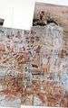
Petroglyphs in the Chiribiquete Natural National Park.
-

Petroglyph in the Chiribiquete Natural National Park. (Possible equine)
-
Petroglyph in the Chiribiquete Natural National Park. Aborigine
-
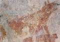
Petroglyph in the Chiribiquete Natural National Park. (possible mammal).
References
- ↑ "Chiribiquete National Natural Park". UNESCO. Retrieved 13 April 2013.
Treasures of Colombia | |||||||||||||||||||||||||||||||||||||||||||||||||||||
|---|---|---|---|---|---|---|---|---|---|---|---|---|---|---|---|---|---|---|---|---|---|---|---|---|---|---|---|---|---|---|---|---|---|---|---|---|---|---|---|---|---|---|---|---|---|---|---|---|---|---|---|---|---|
Archaeological sites · Colombia magia salvaje · National monuments · National parks · World Heritage sites | |||||||||||||||||||||||||||||||||||||||||||||||||||||
| |||||||||||||||||||||||||||||||||||||||||||||||||||||
| |||||||||||||||||||||||||||||||||||||||||||||||||||||
| |||||||||||||||||||||||||||||||||||||||||||||||||||||
Source: Wills, Fernando et al. 2001. Nuestro patrimonio - 100 tesoros de Colombia - Our heritage - 100 treasures of Colombia, 1-311. El Tiempo. | |||||||||||||||||||||||||||||||||||||||||||||||||||||