Chodský Újezd
| Chodský Újezd | |||
|---|---|---|---|
| Municipality | |||
 | |||
| |||
 Chodský Újezd | |||
| Coordinates: 49°52′10″N 12°37′37″E / 49.86944°N 12.62694°ECoordinates: 49°52′10″N 12°37′37″E / 49.86944°N 12.62694°E | |||
| Country |
| ||
| Region | Plzeň | ||
| District | Tachov | ||
| Area | |||
| • Total | 64.78 km2 (25.01 sq mi) | ||
| Elevation | 556 m (1,824 ft) | ||
| Population (2011) | |||
| • Total | 779 | ||
| • Density | 12/km2 (31/sq mi) | ||
| Postal code | 348 11 to 348 15 | ||
| Website | http://www.chodskyujezd.cz | ||

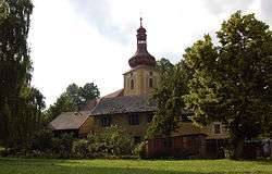
Chodský Újezd (German Heiligenkreuz) is a village and municipality (obec) in Tachov District in the Plzeň Region of the Czech Republic.
The municipality covers an area of 64.78 square kilometres (25.01 sq mi), and has a population of 787 (as at 3 July 2006).
Chodský Újezd lies approximately 8 kilometres (5 mi) north of Tachov, 56 km (35 mi) west of Plzeň, and 131 km (81 mi) west of Prague.
References
| Wikimedia Commons has media related to Chodský Újezd. |
This article is issued from Wikipedia - version of the 11/22/2016. The text is available under the Creative Commons Attribution/Share Alike but additional terms may apply for the media files.