Chudovsky District
| Chudovsky District Чудовский район (Russian) | |
|---|---|
.svg.png) Location of Chudovsky District in Novgorod Oblast | |
| Coordinates: 59°08′N 31°40′E / 59.133°N 31.667°ECoordinates: 59°08′N 31°40′E / 59.133°N 31.667°E | |
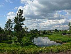 The Kerest River in the town of Chudovo, Chudovsky District | |
 |
 |
|
| |
| Location | |
| Country | Russia |
| Federal subject | Novgorod Oblast[1] |
| Administrative structure (as of April 2012) | |
| Administrative center | town of Chudovo[1] |
| Administrative divisions:[2] | |
| Towns of district significance | 1 |
| Settlements | 3 |
| Inhabited localities:[2] | |
| Cities/towns | 1 |
| Rural localities | 83 |
| Municipal structure (as of January 2012) | |
| Municipally incorporated as | Chudovsky Municipal District[3] |
| Municipal divisions:[3] | |
| Urban settlements | 1 |
| Rural settlements | 3 |
| Statistics | |
| Area (municipal district) | 2,370 km2 (920 sq mi)[4] |
| Population (2010 Census) | 22,011 inhabitants[5] |
| • Urban | 70.0% |
| • Rural | 30.0% |
| Density | 9.29/km2 (24.1/sq mi)[6] |
| Time zone | MSK (UTC+03:00)[7] |
| Established | October 1, 1927[8] |
| Official website | |
| Chudovsky District on WikiCommons | |
Chudovsky District (Russian: Чу́довский райо́н) is an administrative[1] and municipal[3] district (raion), one of the twenty-one in Novgorod Oblast, Russia. It is located in the north of the oblast and borders with Kirishsky District of Leningrad Oblast in the northeast, Malovishersky District in the southeast, Novgorodsky District in the southwest, and with Tosnensky District of Leningrad Oblast in the northwest. The area of the district is 2,370 square kilometers (920 sq mi).[4] Its administrative center is the town of Chudovo.[1] Population: 22,011 (2010 Census);[5] 25,829 (2002 Census);[9] 27,355 (1989 Census).[10] The population of Chudovo accounts for 70.0% of the district's total population.[5]
Geography
The district is located in the Ilmen Lowlands and is crossed by the Volkhov River from southwest to northeast, dividing the district into approximately equal areas. The highest point in the district is 63 meters (207 ft) above sea level.[11] All rivers in the district drain into the Volkhov and its main tributaries, including the Oskuya (right), the Pchyozhva (right), the Kerest (left), and the Tigoda (left).
Over 70% of the district's territory is covered by forests. There are also many swamps, which cover 8% of the territory. The biggest one, Bor Swamp, is located in the valley of the Pchyovzha and is protected as a zakaznik.[11]
History
The Volkhov River served as a major waterway, a part of the trade route from the Varangians to the Greeks, since medieval times. Chudovo was first mentioned as a village in 1539. By the 18th century, it developed into a big selo with a postal service station. The development of the district was further aided by the construction of the Moscow – Saint Petersburg Railway, which opened in 1851. The railway to Novgorod was completed in 1871. A match factory, two cement-making factories, and a number of porcelain factories were built later.[12]
In the course of the administrative reform carried out in 1708 by Peter the Great, the area was included into Ingermanland Governorate (known since 1710 as Saint Petersburg Governorate). In 1727, separate Novgorod Governorate was split off. In 1776, the area was transferred to Novgorod Viceroyalty. In 1796, the viceroyalty was abolished and the area was transferred to Novgorod Governorate. In 1917, Chudovo was the administrative center of Chudovskaya Volost of Novgorodsky Uyezd.
In August 1927, the governorates and uyezds were abolished. Chudovsky District, with the administrative center in the settlement of Chudovo,[13] was established within Novgorod Okrug of Leningrad Oblast effective October 1, 1927.[8] It included parts of Novgorodsky and Malovishersky Uyezds of Novgorod Governorate and of Volkhovsky Uyezd of Leningrad Governorate.[13] On June 25, 1928, Chudovo was granted work settlement status.[13] On July 23, 1930, the okrugs were abolished, and the districts were directly subordinated to the oblast.[14] On January 4, 1931, one selsoviet (Alexandrovsky) was granted ethnic German status, and two others (Derevolatyshsky and Kolomovsky) were granted Latvian ethnic status.[13] On July 20, 1937, Chudovo was granted town status.[13] On April 14, 1939, Kolomovsky Latvian Selsoviet was abolished and merged into Chudovsky Selsoviet and Alexandrovsky German Selsoviet was transformed into a regular selsoviet.[13] Derevolatyshsky Latvian Selsoviet was abolished on September 19, 1939 and merged into Rogachyovsky Selsoviet.[13] Between August and November 1941, during World War II, the whole area of the district was occupied by German troops.[13] Whereas the right bank of the Volkhov was liberated by the Soviet Army between December 1941 and February 1942, battles were fought for a long time for the left bank of the Volkhov.[13] The town of Chudovo and the rest of the district were liberated in January and February 1944.[13] On July 5, 1944, Chudovsky District was transferred to newly established Novgorod Oblast,[13] where it remained ever since.
Economy
Industry
The most developed industries in the district are chemical, food, and timber industries. The former glass-making factory in Chudovo was converted to production of thermoisolating materials. There are enterprises producing matches, plywood, and railroad ties.[15]
Agriculture
The main agriculture specializations in the district are cattle breeding (beef and milk production), as well as production of pork, poultry, and eggs.[16]
Transportation
The Moscow – Saint Petersburg Railway crosses the district from southeast to northwest. Chudovo is the most important railway station, where a railroad to Veliky Novgorod branches off south, and the railway line to Murmansk via Volkhovstroy and Petrozavodsk runs north.
The M10 highway connecting Moscow and St. Petersburg also crosses the district, first following the left bank of the Volkhov River from Novgorod, and in Chudovo turning northwest parallel to the railroad. Roads connect the highway with Malaya Vishera and Chudovo with Budogoshch. Close to the border with Leningrad Oblast, there is a T-shaped intersection with A115 highway, which runs to Volkhov via Kirishi and joins the M18 highway to Petrozavodsk and Murmansk. There are also local roads.
The Volkhov River is navigable for nearly all its length, including in Chudovsky District. However, there is no regular passenger navigation.
Culture and recreation
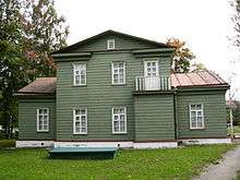
The district contains nine cultural heritage monuments of federal significance and additionally sixty objects classified as cultural and historical heritage of local significance.[17] The federal monuments include the ensemble of the military installations for Count Arakcheyev Grenadier Regiment located in the selo of Selishchi, the house of the author Gleb Uspensky in the village of Syabrenitsy, the house of the poet Nikolay Nekrasov and the school building constructed by him, both located in Chudovo.
There are several museums in the district. The Chudovo District Museum was opened in 1987 and displays collections of local interest.[18] The house of Nikolay Nekrasov is located in Chudovo. This house was bought by Nekrasov to use for hunting. Nekrasov was visited by his friends, some of whom were notable Russian authors.[19] The house of Gleb Uspensky in Syabrenitsy also became a museum.[20]
References
Notes
- 1 2 3 4 Law #559-OZ
- 1 2 Resolution #121
- 1 2 3 Law #368-OZ
- 1 2 Территория вселения "Чудовский муниципальный район" (in Russian). Министерство иностранных дел РФ. Retrieved May 29, 2012.
- 1 2 3 Russian Federal State Statistics Service (2011). "Всероссийская перепись населения 2010 года. Том 1" [2010 All-Russian Population Census, vol. 1]. Всероссийская перепись населения 2010 года (2010 All-Russia Population Census) (in Russian). Federal State Statistics Service. Retrieved June 29, 2012.
- ↑ The value of density was calculated automatically by dividing the 2010 Census population by the area specified in the infobox. Please note that this value is only approximate as the area specified in the infobox does not necessarily correspond to the area of the entity proper or is reported for the same year as the population.
- ↑ Правительство Российской Федерации. Федеральный закон №107-ФЗ от 3 июня 2011 г. «Об исчислении времени», в ред. Федерального закона №271-ФЗ от 03 июля 2016 г. «О внесении изменений в Федеральный закон "Об исчислении времени"». Вступил в силу по истечении шестидесяти дней после дня официального опубликования (6 августа 2011 г.). Опубликован: "Российская газета", №120, 6 июня 2011 г. (Government of the Russian Federation. Federal Law #107-FZ of June 31, 2011 On Calculating Time, as amended by the Federal Law #271-FZ of July 03, 2016 On Amending Federal Law "On Calculating Time". Effective as of after sixty days following the day of the official publication.).
- 1 2 Snytko et al., p. 85
- ↑ Russian Federal State Statistics Service (May 21, 2004). "Численность населения России, субъектов Российской Федерации в составе федеральных округов, районов, городских поселений, сельских населённых пунктов – районных центров и сельских населённых пунктов с населением 3 тысячи и более человек" [Population of Russia, Its Federal Districts, Federal Subjects, Districts, Urban Localities, Rural Localities—Administrative Centers, and Rural Localities with Population of Over 3,000] (XLS). Всероссийская перепись населения 2002 года [All-Russia Population Census of 2002] (in Russian). Retrieved August 9, 2014.
- ↑ Demoscope Weekly (1989). "Всесоюзная перепись населения 1989 г. Численность наличного населения союзных и автономных республик, автономных областей и округов, краёв, областей, районов, городских поселений и сёл-райцентров" [All Union Population Census of 1989: Present Population of Union and Autonomous Republics, Autonomous Oblasts and Okrugs, Krais, Oblasts, Districts, Urban Settlements, and Villages Serving as District Administrative Centers]. Всесоюзная перепись населения 1989 года [All-Union Population Census of 1989] (in Russian). Институт демографии Национального исследовательского университета: Высшая школа экономики [Institute of Demography at the National Research University: Higher School of Economics]. Retrieved August 9, 2014.
- 1 2 Край, в котором мы живем (in Russian). Администрация Чудовского муниципального района. Retrieved May 29, 2012.
- ↑ Администрация Чудовского муниципального района (in Russian). Краткая историческая справка. Retrieved May 29, 2012.
- 1 2 3 4 5 6 7 8 9 10 11 Snytko et al., pp. 145–147
- ↑ Snytko et al., pp. 87–88
- ↑ Промышленность района (in Russian). Администрация Чудовского муниципального района. Retrieved May 29, 2012.
- ↑ Сельское хозяйство (in Russian). Администрация Чудовского муниципального района. Retrieved May 29, 2012.
- ↑ Памятники истории и культуры народов Российской Федерации (in Russian). Russian Ministry of Culture. Retrieved 2 June 2016.
- ↑ Чудовский краеведческий музей (in Russian). Чудово.in. Retrieved January 31, 2012.
- ↑ Дом-музей Н.А.Некрасова (in Russian). Российская сеть культурного наследия. Retrieved February 1, 2012.
- ↑ Дом-музей Г.И.Успенского (in Russian). Российская сеть культурного наследия. Retrieved February 1, 2012.
Sources
- Новгородская областная Дума. Областной закон №559-ОЗ от 11 ноября 2005 г. «Об административно-территориальном устройстве Новгородской области», в ред. Областного закона №730-ОЗ от 26 февраля 2015 г. «О внесении изменений в Областной закон "Об административно-территориальном устройстве Новгородской области"». Вступил в силу 1 января 2006 г. Опубликован: "Новгородские ведомости", №75, 23 ноября 2005 г. (Novgorod Oblast Duma. Oblast Law #559-OZ of November 11, 2005 On the Administrative-Territorial Structure of Novgorod Oblast, as amended by the Oblast Law #730-OZ of February 26, 2015 On Amending the Oblast Law "On the Administrative-Territorial Structure of Novgorod Oblast". Effective as of January 1, 2006.).
- Администрация Новгородской области. Постановление №121 от 8 апреля 2008 г. «Об реестре административно-территориального устройства области», в ред. Постановления №408 от 4 августа 2014 г. «О внесении изменений в реестр административно-территориального устройства области». Опубликован: "Новгородские ведомости", №49–50, 16 апреля 2008 г. (Administration of Novgorod Oblast. Resolution #121 of April 8, 2008 On the Registry of the Administrative-Territorial Structure of Novgorod Oblast, as amended by the Resolution #408 of August 4, 2014 On Amending the Registry of the Administrative-Territorial Structure of Novgorod Oblast. ).
- Новгородская областная Дума. Областной закон №368-ОЗ от 22 декабря 2004 г. «Об установлении границ муниципальных образований, входящих в состав территории Чудовского муниципального района, наделении их статусом городского и сельских поселений, определении административных центров и перечня населённых пунктов, входящих в состав территорий поселений», в ред. Областного закона №6-ОЗ от 27 января 2012 г «О внесении изменения в статью 4 Областного закона "Об установлении границ муниципальных образований, входящих в состав территории Чудовского муниципального района, наделении их статусом городского и сельских поселений, определении административных центров и перечня населённых пунктов, входящих в состав территорий поселений"». Вступил в силу со дня, следующего за днём официального опубликования. Опубликован: "Новгородские ведомости", №2, 12 января 2005 г. (Novgorod Oblast Duma. Oblast Law #372-OZ of December 22, 2004 On Establishing the Borders of the Municipal Formations Within the Territory of Chudovsky Municipal District, on Granting Them the Status of Urban and Rural Settlements, on Establishing Their Administrative Centers, and on Compiling the Lists of Inhabited Localities Within the Settlement Territories, as amended by the Oblast Law #6-OZ of January 27, 2012 On Amending Article 4 of the Oblast Law "On Establishing the Borders of the Municipal Formations Within the Territory of Chudovsky Municipal District, on Granting Them the Status of Urban and Rural Settlements, on Establishing Their Administrative Centers, and on Compiling the Lists of Inhabited Localities Within the Settlement Territories". Effective as of the day following the day of the official publication.).
- Снытко, О. В.; et al. (2009). С. Д. Трифонов; Т. Б. Чуйкова; Л. В. Федина; А. Э. Дубоносова, eds. Административно-территориальное деление Новгородской губернии и области 1727-1995 гг. Справочник (PDF) (in Russian). Saint Petersburg. p. 145. Retrieved May 29, 2011.
| Cities and towns | |||
|---|---|---|---|
| Districts | |||