Clair-Mel City, Florida
| Clair-Mel City | |
|---|---|
| Unincorporated community | |
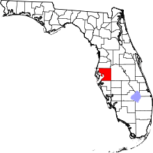
 Clair-Mel City  Clair-Mel City Location within the state of Florida | |
| Coordinates: 27°56′0″N 82°22′42″W / 27.93333°N 82.37833°WCoordinates: 27°56′0″N 82°22′42″W / 27.93333°N 82.37833°W | |
| Country | United States |
| State | Florida |
| County | Hillsborough |
| Area | |
| • Land | 0.64 sq mi (1.66 km2) |
| Population (2010) | |
| • Total | 4,287 |
| Time zone | Eastern (EST) (UTC-5) |
| • Summer (DST) | EDT (UTC-4) |
| ZIP code | 33619 |
| Area code(s) | 813 |
Clair-Mel City (Clair Mel) is an unincorporated community located in Hillsborough County, Florida, United States.
Situation
The community is combined with Palm River to form the census-designated place of Palm River-Clair Mel.
Population
According to the 2010 Census, the community had a population of 4,287.[1] The community is served by a 33619 ZIP Code.
Geography
Clair Mel City is located at 27.93 North, 82.38 West (27.933359, -82.37821),[2] or approximately five miles east-southeast of Tampa. According to the United States Census Bureau, the community had an land area of 0.641 square mile and the population density of 6,691 persons per square mile.[1]
Description
Clair boundaries include Palm River to the west, Tampa city limits to the north, the Lee Roy Selmon Expressway to the east, and Progress Village to the south.
References
- 1 2 Clair Mel City, Florida (33619). City-data. Retrieved 2013-09-18.
- ↑ "US Gazetteer files: 2010, 2000, and 1990". United States Census Bureau. 2011-02-12. Retrieved 2011-04-23.