Colle San Bernardo
For the other pass of the Ligurian Alps, see Colle San Bernardo di Mendatica.
| Colle San Bernardo | |
|---|---|
 | |
| Elevation | 957 m (3,140 ft)[1] |
| Traversed by | National road 582 del Colle di San Bernardo |
| Location | Piedmont, Italy |
| Range | Ligurian Alps |
| Coordinates | 44°10′37″N 8°02′49″E / 44.176849°N 8.046838°ECoordinates: 44°10′37″N 8°02′49″E / 44.176849°N 8.046838°E |
 Colle San Bernardo Location of Colle San Bernardo | |
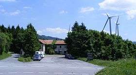
Colle San Bernardo (957 m) is a mountain pass in the Province of Cuneo (Italy). It is located on the main chain of the Alps and connects Garessio with Erli and Albenga (Province of Savona), on the coast of Ligurian Sea. It's traversed by the National road nr. 582 del Colle di San Bernardo
Near the pass is located a small a small wind farm with a total capacity of 12.5 MW.[2]
Main road distances
Hiking
The pass is also accessible by off-road mountain paths and is crossed by the Alta Via dei Monti Liguri, a long-distance trail from Ventimiglia (province of Imperia) to Bolano (province of La Spezia).[3]
See also
References
- ↑ Geoportale IGM on www.pcn.minambiente.it
- ↑ Impianto Eolico di Garessio (CN), article on www.progettazione-impianti-elettrici.it/impianto-eolico-garessio (accessed in February 2015)
- ↑ "Alta via dei monti liguri - Tappa n. 9". www.altaviadeimontiliguri.it. Associazione Alta Via dei Monti Liguri. Retrieved March 7, 2015.
External links
![]() Media related to Colle San Bernardo at Wikimedia Commons
Media related to Colle San Bernardo at Wikimedia Commons
This article is issued from Wikipedia - version of the 3/1/2016. The text is available under the Creative Commons Attribution/Share Alike but additional terms may apply for the media files.