Colorado State Highway 394
| ||||
|---|---|---|---|---|
|
Map of Moffat County in northwestern Colorado with SH 394 highlighted in red | ||||
| Route information | ||||
| Maintained by CDOT | ||||
| Length: | 9.2 mi[1] (14.8 km) | |||
| Major junctions | ||||
| West end: |
| |||
| East end: | Moffat–Routt county line | |||
| Location | ||||
| Counties: | Moffat | |||
| Highway system | ||||
|
Colorado State Highways
| ||||

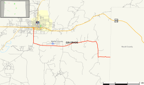
State Highway 394 is a 9.2 mi (14.8 km) long state highway in northwestern Colorado.
Route description
SH 394 begins at a junction with U.S. Highway 40 at Craig and proceeds eastward roughly parallel to US 40. The highway nominally ends after 9¼ miles at the county line between Moffat County and Routt County. The road continues east to rejoin US 40 at Hayden, however, from the county line eastward, the road is not a part of the state highway system and portions of the route are unimproved.
Major intersections
The entire route is in Moffat County.
| Location | mi[1] | km | Destinations | Notes | |
|---|---|---|---|---|---|
| Craig | 0.0 | 0.0 | |||
| | 9.2 | 14.8 | Moffat–Routt county line | ||
| 1.000 mi = 1.609 km; 1.000 km = 0.621 mi | |||||
-
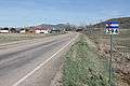
Looking west near where the highway turns west south of Craig.
References
- 1 2 "Segment Descriptions for Highway 394". Colorado Department of Transportation. Retrieved 2008-04-12.
External links
This article is issued from Wikipedia - version of the 9/3/2016. The text is available under the Creative Commons Attribution/Share Alike but additional terms may apply for the media files.